Antique Maps of the Mediterranean

View these historical maps of the Mediterranean area from the 16th through 19th centuries. Each map is illustrated and described. If you are looking for a special map of this area please contact us. The countries surrounding the Medtiterranean have their own pages of antique maps. If you are interested, please look at the maps of these countries: Spain, France, Italy, Greece, Turkey, Holy Land, Sicily, Cyprus and North Africa.

ORTELIUS FIRST EDITION MAPS

Ordering and payment. - Payment may be made in EURO or USD$.

Lieferbedingungen

Sale! Discount!

30% Discount on All maps with a MEDITERRANEAN number on this page!

Take 30% off the listed price. !

Visit us at the following sites:

https://lovelyantiqueprints.com

twitter.com/philographikon2

"Afrique ancienne a l'usage des Colleges"

Hand-colored lithograph showing the Western Mediterranean See with focus on North Africa. Place names and names of political divisions are Antique French. There is a small inset of the area of ancient Cartago.

Map does not disclose author. But the publisher was Librairie de Hachette and dated Paris, 1833.

Very good condition. Vertical centerfold to fit original book size.

Map image: 17 x 21 cm (ca. 6.7 x 8.3")

$ 115.00 (Please look for discount at top of this page. Here 30% = $ 80.50)

Order Nr. MEDITERRANEAN255874


"CARTE DES REGIONS ET DES LIEUX DONT IL EST PARLE DANS LE NOUVEAU TESTAMENT"

Interesting map showing places that are mentioned in the New Testament.
In the lower left is a plan of Jerusalem and in the lower right a detailed inset of Judea
under the rule of Herod the Great. Hand-colored outlines.
Minor signs of age and use in margins. Vertical centerfold.

Map image: 18 x 25 cm ( 7 x 9.8")

$ 120.00

Order Nr. NEAREASTMAP252036


East-Roman Empire - Greece - East Balkan - Turkey - Cyprus - Asia Minor - Palestine - North Africa, Egypt - Libya - Medirearranean Sea.

"Orbis Romani Pars Orientalis Auspiciis Serenissimi Principis Ludovici Philippi Aurelianorum Ducis Publici Juris Facta"

Copper etching by D'Anville. But this map was actually printed and published by Weigel and Schneider in Nuremberg.

With original borderline hand coloring

Nuremberg, 1782

Historic map of the East-Roman Empire with its Capital, here described as "Byzantinum ubi postea Constantinopolis". Place names of all sorts are in the Latin language all around the Mediterranean Sea.

On the center of this map we look at Cyprus and Turkey.

Map was larger than the atlas it was published in. Therefore the map has several horizontal and vertical folds.. It has general age toning and normal signs of age and use. But it is in good condition.

86 x 54,3 cm (ca. 33.9 x 21.4")

$ 320.00

Order Nr. TURKEYMAP252410


"Map of the Countries adjacent to the Corner of the Mediterranean
to Illustrate the Early Passages of St. Paul's Life and his First Journey"

Steel engraving map by H. Hughes, Aldine Chambers at Paternoster Row. .Published 1854.

Routes of St. Paul's journey are shown in blue. Important stops are red underlined.

The map has horizontal folds to fit original book size.
Some light creasing, spotting and minor signs of age and use.

Map image: 31.5 x 24.5 cm ( 12.4 x 9.6")

$ 160.00

Order Nr. MEDITERRANEAN253061


"Erde nach Homer"

Wood engraving map on a page of text about early exploration travels in the Mediterranean.
The text continues on the reverse side. Above Africa is the island "Ogygia", a
mythical island that possibly was Gozo, Malta or other islands known to Homer.
A dotted line shows Homer's travel route in the Mediterranean. Published 1881.

Map image: 11 x 11 cm ( 4.3 x 4.3 ")

$ 25.00

Order Nr. MEDITERRANEAN252920


No title. - Mediterranean Sea (Western part)

From Portugal to Croatia. Norther Africa from Morocco to the Gulf of Gabes (Lesser Syrtis) in Tunesia.

Copper etching by Guillaume-Nicolas Delahaye (1725-1802)

Geographical place names etc: French Language

This map does not show the title cartouche. It was printed in two parts as a large wall map.
We have only the western part of the Mediterranean Sea. Since Delahaye's signature is in
the lower right corner of this map, it may be assumed that the map was created for one
of the French cartographers of the late 18th or early 19th century.

Very good condition with only minor signs of age and use.
Because of large size there are several vertical folds to fit atlas size.

Map image:49,7 x 80 cm (ca. 19.5 x 31.5")

$ 900.00 (Please look for discount at top of this page. Here: 30% = $ 630.00).

Order Nr. MEDITERRANEAN255142


"Divisions de L'Empire Romain sous auguste: pour la Geographie Cpmparee"

Anonymous copper engraving ca 1750. Pleasant hand coloring. Fine condition.

Map image: 26.5 x 34 cm ( 10.4 x 13.3"

" $ 110.00

Order Nr. MEDITERRANEAN252973


Crusades Mediterranean

"Mittelmeerlaender zur Zeit der Kreuzzuege" ( Mediterranean countries at the time of the Crusades )

The upper map shows the countries at the time of the Crusades in 1097.
The lower map shows the countries after the Crusades in 1204.

Published 1896. Vertical centerfold.

22.5 x 28.5 cm ( 8.8 x 11.2 ")

$ 35.00

Order Nr. MEDITERRANEAN248154


"Viaggi D'Ulisse e gli Argonauti"

VoyageS of Ulysses and the Argonauts

Text lower left: Geografia Primitive de Greci second Esiodo ed Omer (Early map of Greece according to Isidor and Homer.

Greece and Ulysse's voyage . Originally hand-colored traces of voyage.

Map's focus is Greece and the island hopping described in Homer's Odyssee

On the far left we find the Straight of Gibraltar and the ãFortunate Islands" = The Canary Islands (here with their Italian name: Isole de Felice. At bottom: North Africa. On the right: The Near East, the Black Sea and much unknown land up north.

Copper etching

Published in ãAtlante di Geografia Universale É per servire al Corso di Geografia Universale"

Author. Francesco Constantino Marmocchi (1805-1858)

Florence, 1840

Very good condition. Very wide margins. Lower right margin corner has yellow stain
well away from image.. Small black spot at bottom

Image Diameter: 24 cm (ca. 9.4")

Sheet: 42 x 50 cm (ca. 16.5 x 19.7")

Order Nr. GREECEMAP255104 SOLD


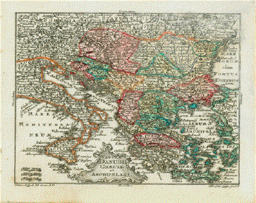
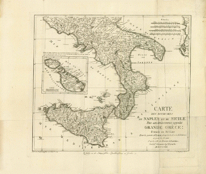
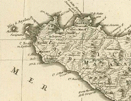
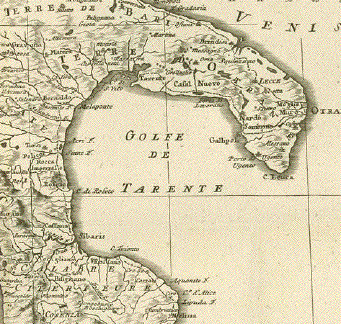
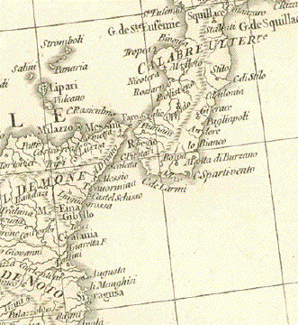
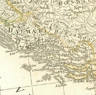
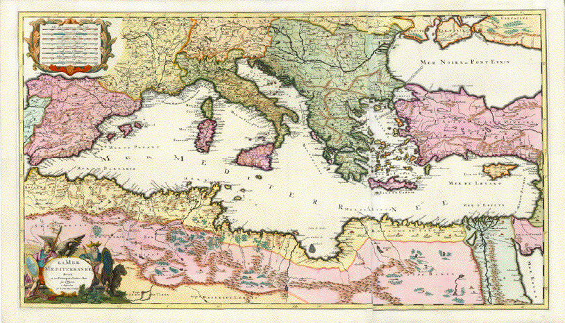
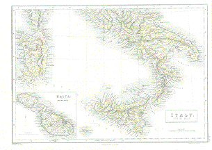
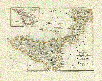
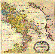
"Carte des Royaumes de Naples et de Sicile. Pays anciennement appellé Grande Grèce: Pour la
Partie d'Italie d'arès la Carte de Zanoni (Giovanni Antonio Rizzi Zannoni (1736-1814) et
pour la Sicile, d'après celle du Baron Schmettau"
(Friedrich Wilhelm Karl Graf von Schmettau, 1743-1806).
The date in thé title cartouche is 1780.

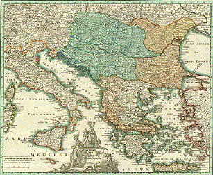
Copper etching by I. Rausch after the design by J.G.K. (we have only these initials)

Dated 1789

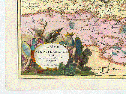
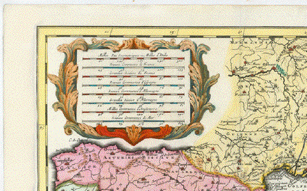
The title cartouche gives information about the cartographic artists.

The part of Italy was designed by  Giovanni Antonio Rizzi-Zannoni (1736-1814)

The of Sicily was designed by Samuel Graf von Schmettau ( 1684-1751)

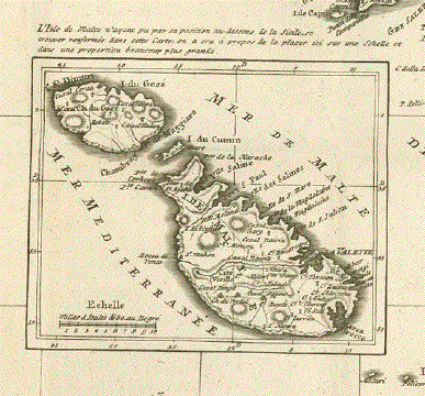
The specialty of this map is the very precise and detailed inset with the Isles of MALTA.

This map was conceived and published as a single sheet map. It was not bound in an atlas.

The publisher was the Ettingerische Buchhandlung (Book store Ettinger) in Gotha.

Publishing date: 1789

Map is printed on excellent heavy paper Map image in strong print and in good condition.
It has, as single sheet maps often do, several vertical and horizontal folds.
The margins have some browning and smudging. Reverse side has some soiling.

Map image. 33,5 x 38,3 cm (ca. 13.2 x 15")

$ 980.00 (Please look for discount at top of this page. Here 30% = ca $ 686.00)

Order Nr. ITALIAMAPPA253362


"Krater de Insel Julia" ( Fernandea )

Wood engraving of the now sunken island also known as Graham Island, Fernandea,
Sciacca, and Giulia. Surrounding the image and on the reverse side is text ( in German )
about this volcano island south of Sicily. Published 1871.

Page size with margins: 17 x 11.5 cm ( 6.6 x 4.5 ")

$ 40.00

Order Nr. MEDITERRANEAN251969


. - "Acquisitiones Phyrrhi Epirotarum Regis situ in Plutarch"

This map shows (as is described by Plutarch) the colonization of Southern Italy
including Sicily by the Gree in the 8th century B.C. The Italian part of the
Greek expansion was called ãMagna Graecia". For many centuries, well into
Christian time the Greek language and the Greek culture was much alive
in the region.  ãRomanizing"  happened late and slowly. Even in our time there are some
"anguage islands" in Apulia and in Calabria, where Greek is still commonly spoken.

Copper etching after Hermann Moll (ca. 1654-1732)

Published in ãGeographia Classica Emendata, ex Graecorum LatinorumqueÉ"

By William Stukeley (1687-1765)

London, ca. 1725

Light general age toning. Some minor traces of age and use in margins. Center fold.

15,3 x 22,5 cm (ca. 6 x 8.8")

$ 125.00 (Please see discount at top of this page. Here 30% = $ 87.00)

Order Nr. GREECEMAP254730


"La Mer Mediterranee divise en ses Principales Parties our Mers"

Very finely hand-colored copper etching by Gerard Valck (1652-1726).

Published in Amsterdam, ca. 1700

The Mediterranean Sea from the Strait of Gibraltar to the eastern shores.

Map was printed from two plates. The border line of the right plate not exactly fitting the left. Hand-coloring and condition are very good.

48,5 x 85,5 cm (19 x 33.7")

Order Nr. MEDITERRANEAN247139 SOLD


"Map to Illustrate St. Paul's 2nd Missionary Journey Representing the Roman Provinces"
"About 50 A.D."

Steel engraving map by W. Hughes in London. Published 1854.

Map image: 17.5 x 24 cm ( 6.8 x 9.4")

$ 45.00

Order Nr. TURKEYMAP253254

"Tabula Danubii Greciae et Archipelagi"

Copper engraving map by Tobias Conrad Lotter(1717-1777) after Tobias Lobeck for
the "Atlas Geographicus portabilis" ((pocket-size atlas) published 1760-1762.
Original hand coloring.

Serbia outlined in orang is at the center of this map that shows the course of the Danube.
In the upper left is Bohemia and Bavaria withRegensburg, Ingolstadt and Munich.
Greece with its many islands and western Turkey fill the eastern Mediterranean Sea.

The imprint in the upper right corner is slightly faded. Otherwise very good condition.

Map image: 9.5 x 12 cm (3.7 x 4.7")

$ 180.00

Order Nr. MEDITERRANEAN252938


"Carte pour le Voyage de Leunant De Pietro della Valle de puzis Venise jusqua Bagdaht, par Constantinople, le Caire, Jerusalem et Alep". Copper engraving by Duval ( Du Val ) (1618-1683). Published. 1666. Hand coloring of a later date.

Very interesting map showing the journing of Pietro della Valle.A fine line on the map shows his intinerary.

Except for a light crease in the upper part of the map, the map is in fine condition.

16.3 x 23 cm ( 6.4 x 9 " )

$ 220.00

Order Nr. NEAREAST235583


Empire romain a la Mort D'Auguste

"Empire romain a la Mort D'Auguste"

Historical steel engravng of the Mediterranean and surrounding lands at the time of the death of Augustus ( ca 14 AD ).
This map was published 1851. Small repaired tear on right margin. Normal folds to fit original book size.

17.5 x 22.5 cm ( 6.8 x 8.8 ")

$ 40.00

Order Nr. MEDITERRANANMAP247241


"Tavola Prima Dell'Asia" (First Ptolemy map of Asia)

Copper etching after Claudius Ptolemaeus published in ãGeografia cioe Descrittione Universale della Terra" Gio. Battista & Giorgio Galignani Fratelli. Venice, 1598

First edition in Italian prepared by Giovanni Antonio Magini (1555-1617)

Map shows Turkey, northern Cyprus, Armenia and the Syrian coastline. Reverse side: North Africa.

Reverse side: "Tavola Quarta dell'Africa" (Fourth Ptolemy map of Asia)

Northern Africa to a suspected Equator. The entire supposed run of the Nile. In the west: The Fortunate Islands (Canary Islands and possibly the Capverde Islands. Southern Europe and of Asia: Trkey, the Near East and Felix Arabia.

General age toning. Minor traces of age and use. A small spot inthe middle of Turkey has a small black spot on account of excessive use of printing ink.

Sheet: 28.5 x 19 cm (11.2 x 7.5")

Map: 12.4 x 17 (4.9 x 6.7")

$ 460.00

Order Nr. ASIAMINOR235652


"Les Colonies Pheniciennes." Copper etching by Bourgoin, published in Paris 1739.

Map shows the location andhas the ancient names of the Phoenician settlements around the Mediterranean.

Map has folds to fit book size and light browning on right margin edge. Upper margin is narrow. Overall condition is otherwise Better than Good.

14 x 16.8 cm ( 5.5 x 6.6 ")

$ 95.00

Order Nr. MEDITERRANEAN1353


"Intineraire d'une transmise de Paris en Algerie par le telegraphie electrique"

Wood engraving on a page printed 1858. Above and below the image is text in French that continues on the reverse side
about the plans for an electric telegraph line from Paris to Algeria.

A few minor spots in image.

14.5 x 15 cm ( 5.7 x 5.9 ")

$ 20.00

Order Nr. MEDITERRANEAN244826


"Imperium Romanum tempore Constantini Magni" Steel etching from "Neuster Zeitungs Atlas. Alter und Neuer Erdkunde" by J. Meyer, ca 1855. Original outline coloring.

Map shows the Roman Empire during the reign of Constantine. Notice that it included all the coutries bordering the Mediterranean Sea.

Map has overall age toning and some light scattered spotting. Light browning in margins. Small piece of upper left margin corner is missing.

18.2 x 24.2 cm ( 7.1 x 9.5 ")

$ 70.00

Order Nr. MEDITERRANEAN1360


"Imperium Romanum tempore Constantini Magni" Steel etching from "Neuster Zeitungs Atlas. Alter und Neuer Erdkunde" by J. Meyer, ca 1855. Original outline coloring.

Map is similar to the above map, but from a different atlas with a different style of coloring.

Map shows the Roman Empire during the reign of Constantine. Notice that it included all the coutries bordering the Mediterranean Sea.

Map is in good condition.

18.2 x 24.2 cm ( 7.1 x 9.5 ")

$ 70.00

Order Nr. MEDITERRANEAN238231


"Das Mittellaendische Meer und Nord Afrika " Steel engraving by A. Petermann for Stieler dated 1871. Original hand outline coloring.

Very detailed map showing the eastern Mediterranean with the Austrian empire and Turkish empires in Europe and Asia at the time.The map reaches as far south as Nubia The map reaches as far west as Sarajevo, the tip of the "heel" of Italy and Bengasi in Lybia. On the middle right is part of the Persian Gulf. Suez is in the lower right corner.

Map image is clean. Tiny repair in lower margin on centerfold.

33.5 x 40 cm ( 13.1 x 15.7 ")

$ 85.00

Order Nr. MEDITERRANEAN236425


" Das Mittlaendische Meer und Nord Afrika " Steel engraving by Poppey and Jungmann for Stieler, dated 1871. Original outline hand coloring.

Interesting map of the western Mediterranean and North Africa. The country borders of the time are colored. On the left side are detailed insets of Malta and Gibraltar. The depths of the Mediterranean near the coasts are given. The railroad routes and main roads are shown in all the countries. The desert and sand dune areas are shown by special symbols.

Map is in very fine condition except for a very tiny repaired tear in lower margin on centerfold.

33.5 x 40 cm ( 13.1 x 15.7 ")

$ 85.00

Order Nr. MEDITERRANEAN236449


"Das Roemische Weltreich nebst Aseiner Theilung in das West und Ostroemische Reich (395 nach Christo)" Wood engraving ca 1875.

Map shows the divisions of the Roman Empire 395 A.D. In the upper right corner is a detail of Asia Minor.

Map has overall light toning. Backside is printed.

19.5 x 25.5 cm ( 7.6 x 10 ")

$ 35.00

Order Nr. MEDITERRANEAN1362


"Italy South. Part" Steel etching by S. Hall for an atlas published in Edinborough, 1859. Printed in a beige monochrome.

Shows southern part of Italy from a line Civita Vecchia, Popoli, Vasto d'Ammone southward.

Detailed is Sicily, Sardinia and - in an inset in the lower left corner of map: Malta/Gozo.

Clean!

26.4 x 37.7 (10.4 x 14.8")

$210.00

Order Nr. ITALIA1523


"Map of the Journeyings of the Isrealites from Eygpt to Canaan". Lithographed map published by A. Fullarton in London ca 1850.

Interesting historical map with lines showing the various paths of the Isrealites journey.

Map has small creases in upper right and lower left margin corners. Small repaired tear on left margin edge.

20 x 24.8 cm ( 7.8 x 9.7 ")

$ 75.00

Order Nr. JUDAICA1367


Copper etching from: "Geographia" by Claudio Ptolemy. Originally edited and published by Willibald Pirckheimer. This edition, which comprises all 64 maps of the "B" edition, including the "New World", was published by Josephus Meletius 1562 in Venice.

This map shows Austria, southern Germany, the Balkans and Italy. In the north is the Danube river and the Carpathian mountains. In the upper left is a bit of the Rhine river. Text on backside gives historical data in Italian of Rhatien and Vindelicia.

Map has light browning and repairs along centerfold. General condition is otherwise Good.

17.7 x 24.2 cm ( 6.9 x 9.5 ")

$320.00

Order Nr.BALKAN1043


Macedonia & c.

In the lower right is Malta and in the
lower left is Madeira.

Wood engraving printed in color, ca 1880.
Map has some tiny repaired tears on margin edges.

29 x 21.5 cm ( 11.4 x 8.4 ")

$ 45.00

Order Nr. MEDITERRANEAN1351


Corsicae Antiquae Tabula. Sardiniae Antiquae Tabula

"Nova Totius Germaniae Descriptio". Copper etching by Peter Bertius (1565-1629) for Philipp Cluver Philipp (1580 - 1623) , an early author of historic maps. His works were published long beyond his lifespan. The This map comes from a pocket size atlas (duodez): Philippi Cluverii. Introductionis in Universam Geographiam tam veterem quam novam Libri. Amsterdam, 1661. Original outline color.

Hardly visible centerfold. Narrow margins all around. Right margin has been widened. General toning. Minimal foxing.

Size: ca.12 x 12,3 cm (ca.4.7 x 4.8").

$ 140.00

Order Nr. MEDITERRANEAN1365


No title. Map of Southern Italy from Naples southward, including Sicilia, most of Sardinia, Malta and Northern Tunesia. Showing also Pentellaria and Linosa.

Anonymous French copper etching with outline hand coloring. Mileage meter in Italian, Piemontese, Roman and French miles at bottom right.

General age toning, some foxing, some spots. Lower margin narrow. Next to centerfold another fold.

Vertical centerfold. Some light scattered spots, mostly in margins. Although map is showing traces of use, it is still getting favorable grades!

30.4 x 44.9 cm (12 x 17.7")

$280.00

Order Nr. SICILIA1446


"Das Koenigreich beider Sicilien suedliche Haelfte: Sicilien un Calabrien 1849." Steel etching from "Neuster Zeitungs Atlas. Alter und Neuer Erdkunde" by J. Meyer, ca 1855. Original outline coloring.

Map has light scattered spotting in lower left corner and in margins.

18 x 24.5 cm ( 7 x 9.6 ")

$ 125.00

Order Nr. SICILIA1442


"Descrittione Dell'Isola Di Sardigna". Copper etching from "L'Isole piu Famose del Mondo" (The most famous islands of the world by Thomas Porcacchi (1530 - 1585) and engraved by Girolamo Porro. The first edition of this work was published in Venice in 1572. This is from the second edition, 1620.

This map is positioned on a page like the one above. A second page is included with the rest of the Italian text. This west-oriented map of Sardinia is surrounded by many smaller islands and sea monsters in the sea. Notice that mountains, rivers and even single trees are shown. The title cartouche is titled: "Sardegna".

The page with the map has a small repaired worm track in the upper margin that does not affect text. Map image is very clean. Some foxing in text and margins. 3.5 cm of left margin has been reinforced at bottom. Light creasing in left margin. Overall condition is Almost Very Good.

Map size. 10.2 x 14.2 cm ( 4 x 5.6 ")
Page size: 27.7 x 19.7 cm ( 10.9 x 7.8 " )

$ 380.00

Order Nr. Italy-1308


" Picentes, Vestini etc. Campania, Apulia, Lucania. Brutii.etc." Copper etching by Peter Bertius (1565-1629)
for Philipp Cluver Philipp (1580 - 1623) , an early author of historic maps. His works were published long beyond his
lifespan. The This map comes from a pocket size atlas (duodez): Philippi Cluverii. Introductionis in Universam Geographiam
tam veterem quam novam Libri. Amsterdam, 1661. Originally colored.Centerfold. Size: ca.12 x 12,5 cm (ca.4.72 x 4.92").
Narrow margins all around, especially on right side. General toning. Minimal foxing.

This map shows the regions given in the title. The names of towns and peoples are from pre-Roman times. On the westside,
the map begins south of Rome. In the southwest are the Liparian Islands and part of Sicily. East of Italy and the Adriatic Sea
is ancient Illyria.

$ 200.00

Order Nr. ITALY1297


"Danubius & Ister cum Domino Turcio in Europa et adjacentibus Regionibus..." Copper etching by Christoph Weigel ( 1654-1725) in original hand coloring. Published in Nuremberg, ca. 1720.

This map features the Danube River from its source in Germany on the left, to its mouth in the Black Sea on the right. The green area in the center shows the Hungarian Empire, Slovenia, Bosnia-Herzogovina and Dalmatia. Not only does this map show the countries of the Danube, but also a large part of southern Europe surrounding the Mediterranean. In the northwest is Frankfurt am Main and in the northeast is part of the Dnieper river.The title is surrounded by four classical figures holding various symbols.

The overall condition of this map is Almost Very Good except for few light spots in lower margin, light browning of right and top edge and a few almost invisible creases along the center fold.

33 x 40 cm ( 13 x 15.7 ")

$ 440.00

Order Nr. BALKAN1241


"Koenigreich beider Sicilien" Lithograph published in Glogau by C.F. Flemming ca 1850. Original light green outline coloring.

Very detailed map reaching as far north as Rome and Termoli.

Map has crease in lower left margin. The upper margin is very narrow. a few tiny creases in lower image.

41 x 32 cm ( 16.1 x 12.5 ")

$ 190.00

Order Nr. SICILIA1441


"Entdeckungen der Phoenizier und Karthager"

Wood engraving map published 1881. This map shows the early exploration routes
of the Phoenicians and Cartaginians. On the reverse side is text about the early travels.

Map image: 11 x 17 cm ( 4.3 x 6.6")

$ 25.00

Order Nr. MEDITERRANEAN252921


Maps of the World

Views of Italy, Views of Malta, Views of Spain, Views of Greece

PRINTS OF THE ENTIRE WORLD: Antique town and city views.

ASTRONOMY

BANKS and FINANCE

BOOKS

BOTANICAL PRINTS

READY TO HANG - Prints and paintings ready to hang!

RELIGION

SCIENCE

SHIPS and SHIPBUILDING

SPORTS

Ordering and payment.

E-mail

Terms of Sale - Lieferbedingungen

Return to Home Page

Impressum

Datenschutz

© Rainer Rauhut