ANTIQUE MAPS OF SOUTH AMERICA - Page 2

This is a selection of our decorative, historical maps of South America.
If you are looking for a particular map please contact us.
Hablamos español.

Ordering and Payment

Sale! Discount!

30% Discount on All maps with a SOUTHAMERICAMAP number on this page!

Take 30% off the listed price. !

We accept reasonable offers.

Visit us at the following sites:

https://lovelyantiqueprints.com

twitter.com/philographikon2

"Sued-Amerika". Steel engraving by L. Thiel after Pr. Lt. Stuelpnagel, dated 1831. Original hand coloring.

Interesting map that shows the political divisions of the time in South America.

Map has vertical centerfold.

A few very light spots in image. Light, scattered spotting in margins.

29.2 x 36.2 cm (11.4 x 14.2 ")

$ 160.00

Order Nr. SOUTHAMERICAMAP2111


"Carte de la Riviere de la Plata". Copper etching. Hand coloring. By a French marine engineer and engraver whose initials are given on this map as M B. Possibly the M. stands for "Monsieur" and B. most likely for "Bellin". The map was published in "L'Histoire Générale des Voyages". Paris, 1746.

Map has a decorative title cartouche. Hardly visible folds to fit original book size.

18.8 x 28.3 cm (7.4 x 11.1")

$ 140.00

 Order Nr. SOUTHAMERICAMAP244854


"Amerique Meridionale"

Copper engraving by F. Delamarche dated 1829. Published 1832.
Original outline coloring. Vertical centerfold. Very minor signs of age and use.

Map Image: 27.5 x 33 cm ( 10.8 x 12.9 ")

$ 75.00

Order nr. SOUTHAMERICAMAP242672


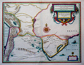
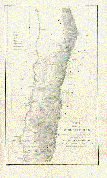
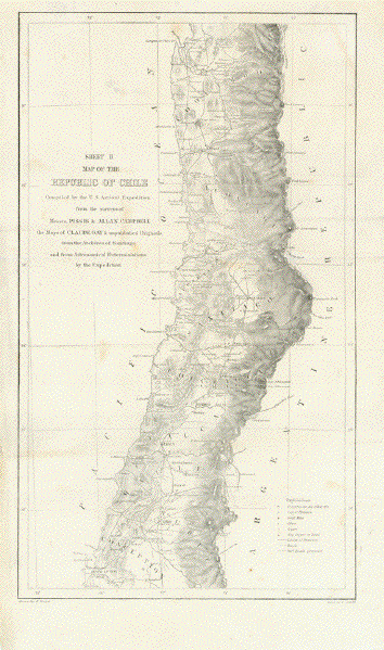
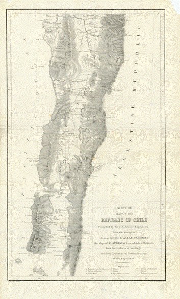
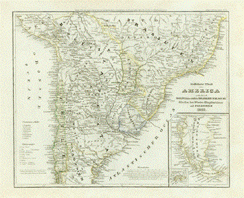
"Map of the Republic of Chile"

Compiled by the U.S. Astron(mica)l Expedition from the surveys of Messrs. Pissis & Allan Campbell, the Maps of Claude Gay & unpublished Originals from the Archives of Santiago and from Astronomical Determinations by the Expedition.

The here-named expediten to the Southern Hemisphere took place from 1849 to 1852. It was published in Washington D.C. in 1855.

The maps of Chile from latitude 24 to latitude 44 were published on three sheets.

Sheet 1 from "La Chimba" to ""Serena"

Sheet 2 from "Tongoy" to "Concepción"

Sheet 3 from north of "Arauco" to the archipelago "Islas Guaitecas".

Explanitory keys show: Copper, gold and silver resources and mines as well as provincial border lines, roads railroads

The maps were drawn by F. Herbst and engraved by Selmar Siebert.

All three sheets show, in their margins, traces of age and use, such as wrinkling, small missing pieces, repaired tears, none of them reaching into the maps themselves. They have pleasant light general age toning. All three sheets have horizontal folds to make them fit into the intended book size.

each map measures: Ca. 41,5 x 24,5 cm (ca. 16.3 x 9.6")

Price for the complete set of three maps: $ 375.00

Order Nr.SOUTHAMERICA242220


"Argentinien, Chile, Bolivia, Uruguay and Paraguay"

Lithographed map published 1892 by the Bibliographisches
Institut in Leipzig. In the lower right corner is a small map
of Switzerland that shows the size of Switzerland compared
to the region of South America on the map.

Horizontal centerfold. Very light natural age toning in margins.

Image: 26 x 20.5 cm (10.2 x 8")

$ 35.00 minus 30% Discount = $ 24.50

Order Nr. SOUTHAMERICAMAP256444


"Amerique Méridionale"

Copper engraving by Rigoberto Bonne. Published by Guillaume Thomas Raynal 1780.

Map has names of native American tribes. Some no longer exist. 

Horizontal centerfold to fit original atlas size. Very clean print.
The paper used for this series of maps was not as strong as some other mapmakers used.

Map image: 31 x 20.5 cm ( 12.2 x 8 ")"

$ 110.00

Order Nr. SOUTHAMERICAMAP250298


" Entwicklung des Kartenbildes von Amerika I."

Wood engraving printed in color 1903. This print shows the development of map making in South America.
In the upper left is the map by Marin Behaim ( 1492) and on the upper right the map by Juan de la Cosa ( 1500 ).
In the lower left is the map by Diogo Riberiro ( 1529 ) and on the lower right the map by Ortelius (1570 ).
Map has a horizontal centerfold.

27.5 x 21.5 cm ( 10.8 x 8.4 ")

$ 35.00

Order Nr. SOUTHAMERICAMAP245748


"America"

Copper engraving map published by Calografia Vignozzi in Livorno ca 1770.
Interesting map of the Western Hemiphere with Italian names. Seldom!

Map has vertical and horizontal folds to fit original atlas size.
Small repaired hole in left margin. A few minor signs of age and use.

Map image. 34.5 x 27 cm ( 13.5 x 10.8")

$ 240.00

Order Nr. NORTHAMERICA254475


"Grundriss von der Conceptions Bay oder Empfaengniss Bay"

Copper engraving with attractive hand coloring. Published 1751 in Lepzig.
This map was published in the German edition of the official acount of the
expedition of Antonio de Ulloa (1716-1795).

Small repair on lower margin edge and lower right margin corner.

Image: 22.2 x 36.5 cm ( 8.74 x 14.3")

$ 150.00

Order Nr. CHILE253354


" Détroit de Magellan". Copper etching by Bellin. Dated 1753. Modern hand coloring.

A very detailed map for its time showing the Strait of Magellen between the mainland of Argentina and Chile and Tierra del Fuego. Below the title of the map is a lettered list giving names corresponding to the letters located in the strait.

Map has overall very light toning and two almost invisible folds to fit atlas. General condition is Very Good.

19 x 34.7 cm ( 7.4 x 13.7 ")

$ 160.00

Order Nr. SOUTHAMERICAMAP2062


"Peru"

An uncommon copper engraving map of Peru by Pierre Duval.
Published 1690 in Paris. Pleasant hand coloring.

On th reverse side is a very old collection stamp.
Centerfold has been flattened.

Map image with border: 10 x 12.3 cm ( 3.9 x 4.7")

$ 90.00

Order Nr. SOUTHAMERICAMAP254103


"America"

Steel engraving by W. Behrens after F. von Stuelpnagel. Dated 1871. Original outline coloring.

Fine map of the american Hemisphere. Many topographical details.

Map is in very good condition. Horizontal centerfold.

40.5 x 30.8 cm ( 15.9 x 12.1 ")

$ 85.00

Order Nr. SOUTHAMERICAMAP237980


"Novus Brasiliae Typus". Copper etching by Blaeu in original coloring. Amsterdam, ca. 1635.

A very decorative map of the Brazilian coast and part of the known inland. The map is west-oriented at the top. Several decorative and documentary depictions of Native Americans and wildlife are shown scattered on the map. Two windoses and two sea monsters decorate the ocean. The inset shows "Baya de todos os sanctos" and the island of Fernaõ de Noronho. Very clearly shown are the major rivers flowing into the Atlantic. To the side of the left windrose is the Tropic of Capricorn close to the city of Rio de Janeiro. The cartouche is held by a native woman and man. Verso: Text in German.

Some light spotting on the map. Some graying caused by extra ink from the copper plate was left on the image at the time of printing which does not substantially devalue the map. A small hole has been repaired close to the right windrose. Slight creasing on center fold. Condition is otherwise Better than Good.

34.5 x 45.5 cm. ( 13 x 18 " )

$ 1800.00

Order Nr. SOUTHAMERICAMAP 2037


ãPartie Orientale de La Terre Ferme ou l'on trouve la Guiane"

The three Guyanas in South America: British Guyana, Dutch Guyana (Surinam), French Guyana

Maps shows very much unexplored land from the border to Venezuela

to Brazil. Much of the Amazonas river with its contrbutors

Hand-colored copper etching by Robert de Vaugondy after the map by de la Condamine.

Paris, dated 1749

Light age toning. Left margin has holes from stitches of binding.

16 x 22 cm (ca. 6.3 x 8.7")

$ 90.00

Order Nr. SOUTHAMERICAMAP238497


ãAmerica noviter delincata"

Copper etching by Henricus Hondius (1597-1651)

Hand colored. Dated 1631 Reverse side text in German ãE" published in Amsterdam 1633.

North and South America. Renaissance cartouche. Inset maps of North and South Pole and a very rich sea staffage with sailing ships and sea monsters. Reverse side text in German.

This Hondius-Janssonius map of the Americas was first published in 1618. California as peninsula and the West Coast as well the East Coast quite detailed for the first half of the 17th century. South America, a bit oversized, shows native people, animals and some more details.

Reference: Burden 192

Condition is very good. Some minor spotting. Centerfold has thin paper in parts.and some minor parallel creasing.

37,5 x 49,8 cm (ca. 14.8 x 19.6

$ 3950.00

Order Nr. SOUTHAMERICAMAP238424


"America 1841"

From "Zeitungs-Atlas fuer alte und neue Erdkunde". Published by J. Meyer. Hildburghausen, Amsterdam and New York. 1849.
Engraved by Joh. David. Original hand coloring.

Interesting map showing the political divisions of the time.

Map has folds to fit original atlas size.Small repair on lower left margin.

26 x 21 cm (10.2 x 8.2 ")

$ 55.00

Order Nr. NORTHAMERICA242287


"Provinces - Unies"
"Du Rio De La Plata, Paraguay, Uruguay et Chili"

Steel engraving map by Duvotenay published 1840.

In the Lower left is the Chiloe Island. In the upper left is the town of Tarapaca.

No upper margin. Two folds to fit original book size.

Image: 22.5 x 18 cm ( 8.8 x 7")

Order Nr. SOUTHAMERICA253736SOLD


"Typus Geographicus Chili a Paraguay Freti Magellanici". Copper etching for the Homann Heirs by de Brouwer, Narbouroug and de Beauchesnec. Published in Nuremberg in 1733. Original hand coloring.

Historically, this map is very interesting. Several notes in Latin about the history of Chile and Paraguay are written to the left of the map in the Pacific Ocean. The information for this map is credited to Alfonso d'Ovalle and Nicol. Techo. Notice that Argentina is named Terra Magellanique. The East coast reaches slightly north of Rio de Janeiro and the Chilean Coast reaches to Arica. The orange area is Paraguay. The inset shows a plan of Santiago de Chile with Río Mapocho. In the upper left is the mileage chart.

There is some light spotting in the margins and a few creases along the vertical centerfold. Strong papaer.

47.7 x 55.8 cm (18.8 x 22 ")

Order Nr. SOUTHAMERICAMAP 244114 SOLD


"La Guyane Francoise avec Partie de la Guayane Hollandoise suivante les operations et les Cartes récentes des Ingenieurs Géographes Francois"

Copper engraving by Rigoberto Bonne. Published by Guillaume Thomas Raynal 1780.

Detailed map of French and Dutch Guyana. 

Horizontal centerfold to fit original atlas size. Very clean print. The paper used for
this series of maps was not as strong as some other mapmakers used.

Map image: 31 x 21 cm ( 12.2 x 8.2 ")"

$110.00

Order Nr. SOUTHAMERICAMAP250300


"Totius Americae Septrionalis et Meridionalis Novissima Repraesentatio quam ex finguilis......" Copper etching by Johannes Baptista Homann ( 1663-1724). Published in 1723. Original hand coloring.

Fine map of the American hemisphere of the time. Notice that much of North America is not yet explored. In the upper right is part of France, Spain and Africa. Notice that many of the Atlantic and Pacific islands are also included. The decorative catouche is supported by Native Americans.

A few signs of age and use in margins. The vertical centerfold has been reinforced with paper repairs.
There is a small paper repair in the Pacifc off the coast of Peru.

Map Image: 48 x 57 cm ( 18.8 x 22.4 ")

$1400.00

Order Nr. NORTHAMERICAMAP253822


" Provinces Unies Du Rio de la Plata, Paraguay, Uruguay, et Chili"

Detailed steel engraving map by Th. Duvotenay, 1840.

The maps extends as far nor as Potosi and Soropalca in Bolivia. In the lower
left is the Island of Chiloe.

Map has two horizontal folds from original publishing.

23 x 18 cm ( 9 x 7 ")

$ 80.00

Order Nr. SOUTHAMERICAMAP249719


Patagonia Malvinas

"Patagonie Terre du Feu et des Malouines"

Steel engraving map by Jenotte showing Patagonia, Tierra del Fuego and Malvinas.

Two horizontal folds to fit original book size.

22.5 x 17.5 cm ( 8.8 x 6.8 ")

$ 60.00

Order Nr. SOUTHAMERICA250499


"America noviter delineata"

Copper etching by Matthaeus Merian (1593-1650)

Map shows North- and South-America based on the world map by Willem Blaeu.

Map has a small inset map at top showing Greenland and Iceland. Notice 

the Azores and Canary Islands in the Atlantic Ocean.

Published by Matthaeus Merian in Frankfurt, 1638

Natural age toning. Light spotting in margins. Centerfold has some parallel folds.
Lower left margin has repair not touching map image.

Map image: 27.5 x 35.5 cm ( 10.8 x 13.9 ")"

Order Nr. NORTHAMERICA250042SOLD


"Suedlicher Theil von America enthaltened Bolivia, das suedliche Brasilien, Paraguay, Chile, La Plata, Cisplatina und Patagonien, 1850. Steel etching from "Neuster Zeitungs Atlas. Alter und Neuer Erdkunde" by J. Meyer, ca 1860. Original outline coloring.

Very detailed map with a special inset of Patagonia and the Falkland Islands.

Map is clean and in fine condition.

21.2 x 26.2 cm ( 8.3 x 10.3 ")

$ 80.00

Order Nr. SOUTHAMERICAMAP2124


"Teil einer Karte von America in einem spanischen Atlas aus dem Jahre 1582."
( Part of a map of America in a Spanish Atlas from 1582 )
"Nach dem Original von Juan Martinez in der Bibliothek des Pariser Arsenals"

Wood engraving printed in color ca 1900. This colorful map color windroses, mountains,
towns topographical elements reaching as far south as Rio de la Plata and Patagonia.

Vertical centerfold.

Map image: 21 x 30 cm ( 8.2 x 11.8 ")

$ 90.00

Order Nr. SOUTHAMERICAMAP248790


"Carte De L'Amerique Meridionale, Pour l'Histoire Generale"

Copper engraving by Bellin, 1754. Attractive hand coloring.

Notice that the coastal regions are detailed as the interior of South america was not yet really explored at this time. The map shows the know regions of the time with their early names.

Map has folds to fit original book size. Some spotting in lower margin and a light stain in lower left area.
One fold has been reinforced.

44 x 32.5 cm 17.3 x 12.7 ")

Order Nr. SOUTHAMERICAMAP241851 SOLD


"Peru, Ecuador, Kolumbien u. Venezuela"

Map published in Leipzig, 1892. Horizontal centerfold. Light natural age toning.

25.5 x 21 cm ( 10 x 8.2 ")

$ 40.00

Order Nr. SOUTHAMERICAMAP251617


"Colombie et Guyanes"

Steel engraving for Th. Duvotenay ca 1845.

Map has folds to fit original book size.

18 x 23 cm ( 7 x 9 ")

$ 55.00

Order Nr. SOUTHAMERICAMAP239946


"Entwicklung des Kartenbildes von Amerika II"

Wood engraving printed in color showing the development of American maps from J. B. Homann (1716 )
on the left to A. Stieler (1823) on the right. Published 1903.

13.5 x 21 cm ( 5.3 x 8.2 ")

$ 25.00

Order Nr. SOUTHAMERICAMAP245747


"Brasilien, die Argentinischen Republiken, Bolivia, Peru u. Ecuador" Wood engraving by L. Salziger after L. Ravenstein, ca 1875. Printed in color.

Map has vertical centerfold. A few minor, scattered spots.

20.5 x 26.7 cm ( 8 x 10.5 ")

$ 45.00

Order Nr. SOUTHAMERICAMAP2112


"Suedamerica". Steel engraving by H. Eberhardt in Eisenach, ca 1850.

Very detailed topographical map of South America with dotted lines showing the boundaries of the various countries.

25.7 x 20.7 cm ( 10.1 x 8.1 ")

$ 55.00

Order Nr. SOUTHAMERICAMAP2113


"Carte Du Detroit De La Maire" Copper engraving by Bellin, dated 1753.

Map shows Tierra Del Fuego on the right and Isla Del Estado (Staten Island) on the right.

Map has vertical centerfold.

19.4 x 27.5 cm ( 7.6 x 10.8 ")

$ 95.00

Order Nr. SOUTHAMERICAMAP2114


"Süd-America.". Steel etching in recent coloring. Atlas printed and published by C. Flemming in Glogau, ca. 1840.

The northeastern part of South America with Brazil, the Guianas, Surinam and parts of Venezuela, Bolivia and Paraguay are shown on this map of South America.

The map has some vertical creasing. Otherwise the condition is Very Good.

36.5 x 27.1 cm (14.4 x 10.7")

$ 230.00

Order Nr. SOUTHAMERICAMAP 2046

Also available are two other maps from the same atlas with the other regions of South America.


" America Meriondale" 

Lithograph by G. Bonatti in Turin for the Fratelli Doyen in Turin. Michele Doyen (died in 1871)
founded a lithography business in 1832 in Turin. In 1848 his brother, Leonardo,
joined the business. This map was printed in Turin about 1850.

The entire South American Continent is shown on this map. To the southeast are the
Falkland Islands. It´s a very detailed map, not only showing the
centers of population, but detailed topography.

Light natural age toning. There is a horizonal fold in the middle and
a second fold in the lower half.

Map image: 37.8 x 25.2 cm ( 14.9 x 9.9 ")

$ 110.00

Oeder Nr. SOUTHAMERICAMAP250132


"Paraguayo,o Prov. de Rio de la Plata cum regionibus adiacentibus Tucuman et S.ta Cruz de la Sierra." Copper etching in original coloring. By Johann Janssonius (+1660). Amsterdam, ca. 1650.

The beutiful original coloring of this map outlines the region of South America showing Paraquay, and parts of Peru, Chile, Argentina, Brazil and Bolivia. Much of the area was still "Terra Incognita" so there are few towns and cities shown. The Andes are clearly shown to the west as well as the river systems. The Renaissance cartouche adds a special decorative accent to the map. The small cartouche in the lower right gives the name of the cartograph.

The middle fold has vertical folds which are reinforced in the lower margin. Between the title cartouche and margin is an area of 9x4 cm. that is reinforced because the map is very thin in this area. Some spotting on the margins. Conditon is Good.

37.7 x 48.5 cm (14.8 x 19.1")

$ 1100.00

Order Nr. SOUTHAMERICAMAP 2047


"Sued-Brasilien"

Map shows Brazilian coast and hinterland from Cap S. Thome - Rio de Janeiro -

S. Paulo - Porto Allegre - Rio Grande. Nicely detailed

Lithograph. Printed in color

Leipzig, 1892

Light age toning.

21,3 x 13,3 cm (ca. 8.4 x 5.2")

$ 40.00

Order Nr. SOUTHAMERICAMAP239303


"Carte des Etats-Unis de la Nouvelle Grenade...."

Two pages showing Colombia, Venezuela and Panama at the time the region was known as "New Ganada" Maps are very detailed especially showing the many rivers and mountais. The early settlements are shown. The left map extends as far south as Quito.

Wood engravings by R. Duguay-Trouin, published 1872.

Both pages have print on the reverse side.

Image size of each map: 23 x 15.5 cm ( 9 x 6.1 ")

$ 65.00

Order Nr. SOUTHAMERICAMAP240238


"Florenkarte von Sued- u. Mittel-Amerika"

Wood engraving printed in color showing the various botanical regions of South America and Central America.
Te names of the various regions are printed in red. This map was published 1903. Small repaired tear in lower left corner.

20 x 14.5 cm ( 7.8 x 5.7 ")

$ 25.00

Order Nr. SOUTHAMERICAMAP245742


"Karte der Forschungsreisen in sued und Mittel-Amerika"

Wood engraving map printed in color 1903. Map shows the may exploration routes of the
explorers traveling to South America, Central America and the Caribbean. In the lower left is
a detail of Patagonia. The names of the explorers and dates are written on the lines.

21.5 x 15 cm ( 8.4 x 5.9 ")

Order Nr. SOUTHAMERICAMAP245750 SOLD


Cartagena

"Neu und verbesserter Plan des Hafen von Cartagena"

Copper engraving by Homann Heirs in Nuremberg, ca 1750. Original hand coloring.

Detailed print of the harbor of Cartagena and the surrounding area.
"North" is on the left side, "East" at the top of the print.
In the lower right is text in German describing Cartagena.

Upper margin is the pink area. Other margins wide. A few scattered spots in margins.

22.7 x 28 cm ( 8.9 x 11 ")

$ 350.00

Order Nr. SOUTHAMERICAMAP 2550


"Terra Firma et Novum Regnum Granatense et Popayan". Copper etching by Johannes Janssonius ( 1588-1664) - also known as Jan Jansson, published in Amsterdam ca 1640. Original hand coloring.

This map shows Panama and the northwest part of South America as far south as the Equator. In the upper right is Lake Maracaibo and the Golf of Venezuela. Notice the windroses in the Carribean and Pacific Ocean. Verso: Text in Latin.

Map has light toning and some browning along the lower part of centerfold. Margins are a bit smudged with water stains in the upper corners. There is a small spot over the map legend and a crease to the right of centerfold. Condition is Almost Very Good.

37.5 x 48.5 cm ( 14.8 x 19.1 ")

$ 840.00

Order Nr. CARIBBEANMAP2003


"South America"

In the lower right is an inset of Panama showing the Canal region.
In the upper left margin are the Galapagos Islands.

Wood engraving printed in color ca 1890. On the reverse side is text and images of Argentina.
Overall light age toning.

27 x 22 cm ( 10.6 x 8.6 ")

$ 30.00

Order Nr. SOUTHAMERICAMAP238855


"La partie Meridionale de l'Amerique appelée Terre Ferme ou se trouve les Provinces ou Grands Gouvernemens de La Guiane et de La Nouvelle Grenade ..." Copper etching in original coloring. By Nicolas de Fer (1646-1720), Paris 1719.

This map shows the northern region of the South-American Continent with special emphasis on the Amazon River and its many tributaries.

This map has three vertical folds parallel to the center fold, one to the left and two to the right that allowed the map to be folded in an atlas. The is one crease between the middle folds. The margins have some dirt spotting. The condition is otherwise Very Good.

47.8 x 63 cm (18.8 x 24.8")

$ 820.00

Order Nr. SOUTHAMERICAMAP 2045


"Brasilien"

Historical map of Brazil published 1895. In the upper right is a detailed inset showing Rio de Janiero
and the durrounding area. In the lower left is an inset showing Uruguay. The inset in the lower right corner
shows Santa Catarina and environs.

Map has a horizontal centerfold.

27.5 x 21.5 cm ( 10.8 x 8.4 ")

$ 25.00

Order Nr. SOUTHAMERICA244688


"Flusskarte von Nord- u. Sued-America"

Rivers in North and South America

Anonymous steel engraving

Original border line hand-coloring

Probably Leipzig, Germany, ca. 1850

Text below map gives all important rivers on earth in the order of their length.

Two vertical folds to fit book size. Condition is very good.

21 x 27,5 cm (ca. 8.3 x 10.8")

$ 70.00

Order Nr: SOUTHAMERICA240822


"Bresil"

Engraved map by Th. Duvotenay, 1837. Detailed map of the early settlements of the time. The many Brazilian rivers are shown with their tributaries.

Clean map. Two original horizontal folds to fit book size. Very minor signs of age and use.

23 x 18 cm ( 9 x 7 ")

$ 45.00

Order Nr. SOUTHAMERICA240841


"Partie Orientale de la Terre Ferme ou l'on trouve la Guiane". Copper etching. Gilles Robert de Vaugondy (1688-1766) was heir to the cartographic material of his uncle Pierre Moulard Sanson, (grandson of Nicolas Sanson d'Abbéville) whose maps were considered to be geographically the best of their time. Robert bought the cartographic estate of Charles-Hubert-Alexis Jaillot (1640-1712) and published, together with his son Didier (1726-1786) first a small atlas in 1748 and a large folio-size atlas in 1752. This map stems from the small atlas. The map has recent coloring and is in Good Condition. In the left margin are stitch holes from bookbinding.

16 x 22.4 cm ( 6.3 x 8.8 ")

$ 95.00

Order Nr. SOUTHAMERICAMAP 2035


"Die Andenbahnen" ( The Andes Railroads )

Wood engraving showing the very early railroads in Peru. Ca 1880. Published by A. Hartleben.
Printed in color. Light overall age toing.

13 x 18.9 cm ( 5.1 x 7.4 ")

Order Nr. S0UTHAMERICAMAP237657 SOLD


"Sued America in zwei Blaettern " ( South America on twp üpages )

Steel engraving after F. von Stuelpnagel for Stieler dated 1871. Original hand outline coloring.
This map is the northern part of the map below. Both map pages are the same size.

Vertical centerfold. Good condition.

Map size: 32.8 x 40 cm ( 12.9 x 15.7 ")
Page size: 37.5 x 45.5 cm ( 14.7 x 17.9 ")

$ 90.00

Order Nr. SOUTHAMERICAMAP238151SOLD


"Der Suedliche Theil von Sued-America"

Steel engraving for Stieler dated 1871. Original hand outline coloring.

This map is the northern part of the map below. Both map pages are the same size.

On the right side center is a inset showing Rio de Janeiro and the surrounding area.
In the lower right is a detailed street map of Rio de Janeiro.

Map has some minor spots in margins. Good condition. Vertical centerfold.

Map size: 31 x 40 cm ( 12.2 x 15.7 ")
Page size: 37.5 x 45.5 cm ( 14.7 x 17.9 ")

$ 90.00

Order Nr. SOUTHAMERICAMAP237633SOLD


" Amerique du Sud Amerique du Nord"

Map of South and North America printed in color ca 1890. Of special interest
is the small map in the lower center of France. It shows the size of these two
very large continents in comparison to France. In the lower left is a small
map inset of the Galapagos Islands. In the upper right is Iceland.

The map has two vertical folds and one horizonal fold to fit original book size.
In the lower left is a part of the margins missing that was bound in the book.
Light natural age toning.

Image: 27 x 40 cm (10.6 x 15.7")

$ 55.00 minus 30% Discount = $ 38.50

Order Nr. NORTHAMERICA256128


"Physical Map of South America". Wood engraving printed in color. Dated 1875. Physical map with emphasis on topographical features.

Light overall age toning. Backside is printed.

27.2 x 21 cm ( 10.7 x 8.2 ")

$ 35.00

Order Nr. SOUTHAMERICAMAP2105


"Political Map of South America". Wood engraving printed in color. Dated 1875. Political map with emphasis on political divisions of the time.

Light overall age toning. Backside is printed. Tiny repaired tear on lower margin edge.

27.2 x 21 cm ( 10.7 x 8.2 ")

$ 30.00

Order Nr. SOUTHAMERICAMAP2106


"Brasil, Divided into its Capitainships.". Copper etching by Hermann Moll (1678-1732). Published ca 1710.

Not only is the map shown interesting, but also the text on both sides of the page is very informative with a description (in English) of the land and Brazilian peoples of the time. At the top of the map is the mouth of the Amazon. In the lower part of the map is the Tropic of Capricorn.

Map image has been printed very close to left edge. Margin edges are somewhat browned. Light staining on right margin edge. Brown spot by the Bay of Todos Os Santos. General condition is just Good.

Map size: 16.2 x 18.7 cm ( 6.3 x 7.3 ")
Page size: 31.8 x 21.7 cm ( 12.5 x 8.5 ")

$ 130.00

Order Nr. SOUTHAMERICAMAP 2082


"Terra Firma and the Caribbe Islands". Copper etching by Hermann Moll (1678-1732). Published ca 1710.

This map shows part of South America north of the Equator. In the lower right is the mouth of the Amazon River. In the upper left is part of Cuba. Text in english about landscape and history on both sides of page.

Map is not printed squarely on page. Brwoin along upper and right margins. Water stain in lower margin. General condition is Better than Good.

Page size: 31.8 x 21.7 cm ( 12.5 x 8.5 ")
Map size: 15.7 x 18.7 cm ( 6.2 x 7.3 ")

$ 130.00

Order Nr. SOUTHAMERICAMAP 2086SOLD


"Pascaarte vande Zee custen van Guinea, en Brasilia; Van Cabo de Verde, tot C. de vona EsperançA: en van R. de Amazones tot Rio de la Plata, alles op wassende graaden gestelt. t Amsterdam." Copper etching von Johannes van Keulen (1654-1711) for "De Groote Nieuwe Vermeerderde Zee Atlas ofte Water-werelt". Published ca 1710. Original hand coloring.

This interesting map was made primarily for sailors. Notice the many windroses and ships in the Atlantic. On the right side is part of Africa and on the left this map shows the eastern part of Brazil with French Guiana and the mouth of the Amazon in the north. The coastline reaches as far south as Río de la Plata. A decorative cartouche adds to the attraction of this map.

Map is shown photographed against a light background. Margins are narrow. Map has been mounted on stronger paper. There is a 5 cm repaired tear on left edge. Along the upper edge is a dark spot. General condition is Much Better than Good.

51.5 x 59.3 cm ( 20.2 x 23.3 ")

$1670.00

Order Nr. SOUTHAMERICAMAP 2080


Maps of the World

"America 1849" Steel etching from "Neuster Zeitungs Atlas. Alter und Neuer Erdkunde" by J. Meyer, ca 1855. Original outline coloring.

Nice map of the Americas and part of Polynesia.

25.5 x 21.2 cm ( 10 x 8.3 ")

$ 65.00

Order Nr. NORTHAMERICAMAP2103


Return to Maps of South America - page 1

Maps of the World

Views of South America

Views of Brazil

Scenes and Costumes of South America

E-mail

Terms of sale - Lieferbedingungen

Ordering and Payment

Return to Home Page

Impressum

Datenschutz

© Rainer Rauhut