Antique Maps of Asia Minor

View our selection of historical maps of Turkey and the surrounding area. Each description is illustrated. Please contact us if you are looking for a special map. There are maps of Asia Minor with Maps of the Mediterranean and Maps of Caucasia. Maps have normal age toning and wider margins than shown on these images.

Ordering and Payment

Lieferbedingungen

Sale! Discount!

30% Discount on All maps with an ASIAMINORMAP number on this page!

Take 30% off the listed price. !

Visit us at the following sites:

https://lovelyantiqueprints.com

twitter.com/philographikon2

Asia Minor

Greece

Klein Asien

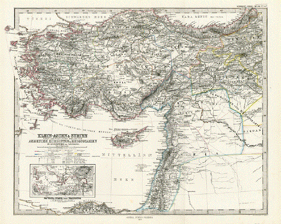
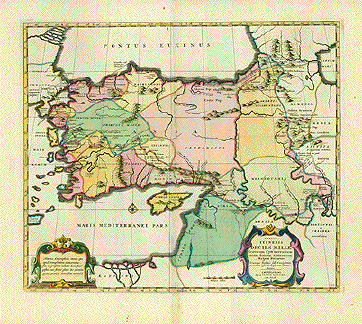
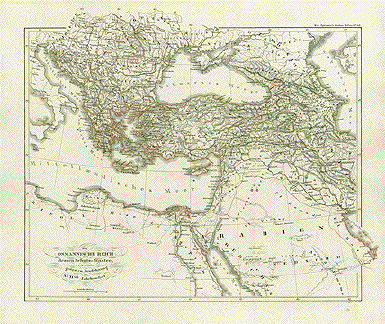
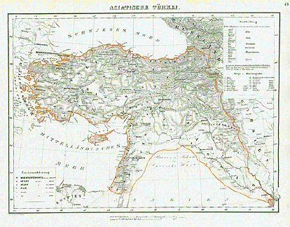
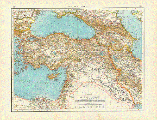
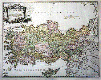
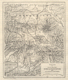
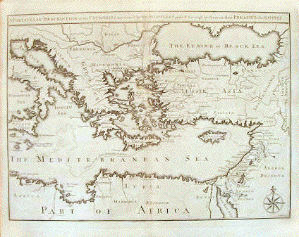
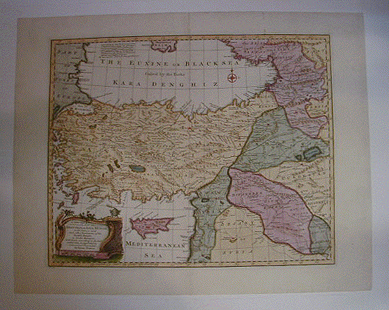
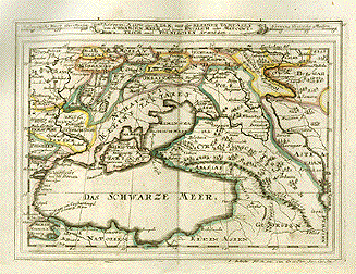
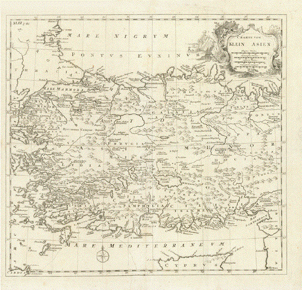
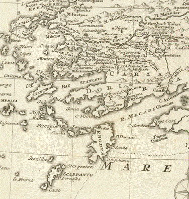
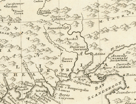
"Charte von Klein Asien"

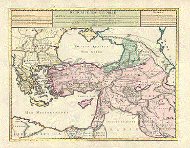
Anonymous copper etching. Map had once clearly been bound in a smaller book size ( vertical and horizontal folds recognizable ).

Title in German, but provinces and other geographical incices ( cities, islands, rivers ) in Latin.

Map has been laid down on thin matting materia, so that all the folds have been smoothened out.

Quite detailed and interesting map of Western Turkey including the northern part of Cyprus
and the offshore Greek islands.

37 x 39 cm ( 14.5 x 15.4 ")

$ 260.00

Order Nr. ASIAMINORMAP248372


"Klein-Asien & Syrien Nebst den Westlichen Theilen von Armenien, Kurdistan & Mesopotomien " Steel engraving by Eulenstein and Jungmann for Stieler dated 1870. Original outline hand coloring.

Very detailed map. Inset in lower left corner shows the region of Smyrna (Izmir).

Vertical centerfold. Good condition.

33.5 x 40 cm ( 13.1 x 15.7 ")

Order Nr. ASIAMINOR236338SOLD


ãDas Byzantinische Reich bis in das XI. Jahrhundert" (Byzantine Empire to the XIth century). Steel engraving by C. Poppey. Published in Spruner's historical atlas ca 1865.

Map shows Turkey, Greece, Islamic Bulgaria, Cyprus. Inset lower left bird's eye view of Constantinople. Names all different ãtribes" in this lively geographical area. An interesting historical map.

Clean. Right margin narrow.

33 x 43.2 cm (13 x 17")

$ 120.00

Order Nr. ASIAMINOR1834


ãTurcicum Imperium" (Osman Empire / Osmanisches Reich)

Hand-colored copper etching by Joannes L'Huilier

Published by Frederic de Wit

Amsterdam, ca. 1680

General age toning. Lower left and lower right spotty.

Lower centerfold and fragil sections left and right secured by

restaurative paper. Very good hand-coloring probably 19th century.

Reverse side has no print. In general: Still good condition.

Map shows extension of the Osman Empire versus the end of the 17th century. Center of map is Turkey, Irak, the Levant, northern Egypt, the Libyan coast, Greece, The Black and the Caspean Sea. Very colorful cartouche shows three sultans and two captives.

Ca. 45 x 55 cm (ca. 17.7 x 21.6")

$ 880.00

Order Nr. NEAREAST237379


"Turchia Nell Asia Antica E Moderna". Copper etching ca 1720. Modern hand coloring.

This is an Italian edition of the above map. It concentrates on eastern Turkey and the surrounding countries. In the upper left is the southern tip of the Crimea in the Black Sea. In the upper right is part of the Caspian sean. In the lower left is the northern tip of the Red sea and in the lower right is the northern tip of the Persian Gulf. To the left of the Holy Land is Cyprus.

Map image is clean. Light creasing in lower left image area. Left margin has been added. Hardly visible folds to fit book size. Right margin is a bit frayed with some creasing. General condition is Much Better than Good.

17 x 13.5 cm ( 6.7 x 5.3 ")

$140.00

Order Nr. ASIAMINOR 1822


ãTabula itineris Decies Mille Graecorum Cyro merentium contra fratrem Artaxerxem Regem Persarum..." Copper etching from the atlas by Pierre Mortier (1661- 1711). Amsterdam. Ca 1700.

Historical map relating to ãAnabais" a collection of war stories about Greek antique times written by Xenophon. The story of this map pertains to the Ten Thousand Greek mercinaries (whom Xenophon accompanied) who had been hired by Cyrus the younger, who intended to seize the throne of Persia form his brother ArtaxerxesIn the battle of Cunaxa in Babylonia these troups beat their enemy, but Cyrus was killed in battle. The expedition therefore was in vain. After all generals and leaders of the army had been killed or captured the headless army was stranded deep in enemy territory. The 10000 then marched togerther to the Black Sea. All this according to Xenophon in his ãAnabis" (The March North).

Map shows Turky, Cyprus, Armenia and the Near East to Bagdad.

Map has wide margins with light bowning on margin edges. Light browning along vertical centerfold. Small repair in upper margin on centerfold. A few scattered spots in margins. Small repaired tear on lower margin edge. Tiny repaired hole on upper centerfold.A few hardly noticeable creases.

40 x 47 cm (15.7 x 18.5")

$ 620.00

Order Nr. ASIAMINOR1841


ãTabula itineris Decies Mille Graecorum sub Cyro contra fratrem suum Artaxerxem Regem Persarum..." Copper etching by Pierre Duval (1619 - 1683). Ca1665. Recent hand coloring.

Historical map relating to ãAnabais" a collection of war stories about Greek antique times written by Xenophon. The story of this map pertains to the Ten Thousand Greek mercinaries (whom Xenophon accompanied) who had been hired by Cyrus the younger, who intended to seize the throne of Persia form his brother ArtaxerxesIn the battle of Cunaxa in Babylonia these troops beat their enemy, but Cyrus was killed in battle. The expedition therefore was in vain. After all generals and leaders of the army had been killed or captured the headless army was stranded deep in enemy territory. The 10000 then marched togerther to the Black Sea. All this according to Xenophon in his ãAnabis" (The March North).

Map shows Turky, Cyprus, Armenia and the Near Est to Bagdad. Has three decorative cartouches.

Map has very wide margins with some light browning on margin edges. There are some fine parallel creases along the vertical centerfold. A few light creases in image.

41.3 x 49 cm (16.3 x 19.3")

$ 620.00

Order Nr. ASIAMINOR1840


" Turquie D Asie a L Exception des Enclaves Situees en Arabie" Copper etching by André for Rigobert Bonne (1729-1795), published ca 1780.

Detailed map showing Turkey and parts of the Middle East and Near East.

Map has vertical fold to fit atlas size. Light age toning and light stain on upper margin edge.

23.5 x 34.5 cm ( 9.2 x 13.5 ")

$ 130.00

Order Nr. MIDDLEEAST236078


"Reditus decum Millium Graecorum Juxta Xenophontem". Copper etching by Hermann Moll, 1749. Modern
hand coloring.

Map showing Turkey and Mesopotamia with names of ancient settlements.

Light browning along centerfold and along margin edges. Other the condition is Almost Very Good.

15.1 x 22.5 cm ( 5.9 x 8.8 ")

$ 140.00

Order Nr. ASIAMINOR 1821SOLD


Carte du theatre de la guerre in Asie.

Wood engraving ca 1865. Reverse side is printed. Overall light age toning.
Right margin is narrow. Some very light spots.

In the upper left is Bafira and Samsoun. In the upper right are the Caucasus Monts with Kasbek. In the lower right is an inset showing the region of the map. In the lower middle is Diarbekir and parts of Kurdistan.

16.5 x 23 cm ( 6.4 x 8.6 ")

$ 30.00

Order Nr. ASIAMINOR2013


Reverse side of map.


ãTabula III Asiae". INCUNABLE MAP! Woodcut Ptolemy edition. Strassburg 1522. Repeat of the edition by Waldseemueller / Frisius of 1513, also Strassburg. Explanatory text on reverse side in Latin language. Modern hand coloring.

Map of Caucasia region, especially of Greater Armenia. This map shows the area between the Black Sea and the Caspian Sea as far south as the headwaters of the Tigris River in the south (east Turkey, Armenia, Azerbbaidzhan). Interesting place names.

A little insignificant fraying along edges. Minor creasing in margins. Otherwise in very good condition for its age.

30 x 37 cm (11.8 x 14.6")

$ 1400.00

Order Nr. ASIAMINOR2012


"Turquie en Asie Anciene et Moderne". Copper etching ca 1720. Modern hand coloring.

This map concentrates on eastern Turkey and the surrounding countries. In the upper left is the southern tip of the Crimea in the Black Sea. In the upper right is part of the Caspian sean. In the lower left is the northern tip of the Red sea and in the lower right is the northern tip of the Persian Gulf. To the left of the Holy Land is Cyprus.

The lower left corner margin has been added. Map is very clean with hardly visible folds. Condition is Almost Very Good.

17 x 13.5 cm ( 6.7 x 5.3 ")

$ 130.00

Order Nr. ASIAMINOR 1817


ãDas Osmanische Reich und dessen Schutzstaaten nach seiner grössten Ausdehnung im XVIIten Jahrhundert". (The Osman Empire's largest extension in the XVIIth century.) Steel etching by W. Alt. 1846. Faint borderline coloring.

Clean, except for traces of age and use in margins.

Thin worn spot upper right in explanatory text.

Page size: 37 x 43.8 cm (14.6 x 17.2").

$ 130.00

Order Nr. ASIAMINOR1844


ãAsiatische Tuerkei". Asian Turkey. Steel etching by F. Kunzer. 1846. Borderline coloring around the largest extension of Turkey in mid 19th century.
Map shows Turkey, Cyprus. Near East including Syria, Lebanon, Irak to Kuwait. Holy Land to the Dead Sea.

Clean, except for traces of age and use in margins. Thin worn spot upper right in explanatory text.

Page size: 37 x 43.8 cm (14.6 x 17.2").

$ 130.00

Order Nr. ASIAMINOR1845


ãGriechenland und Kleinasien vom XIten bis in die Mitte des XIIIten Jhdts." Greece and Asia Minor from the XIth to the middle of the XIIIth century. Steel etching by. W. Alt 1846. Some original borderline coloring.

Map shows Greece and most of Turkey. Side maps: Linadia and Morra. Hellespont & Propontis.

Clean. Left and right margins narrow.

Page size: 37 x 43.8 cm (14.6 x 17.2").

$ 150.00

Order Nr. GREECE1291


ãGriechenland und Kleinasien bis zur Eroberung Konstantinopel's durch die Osmanen...1453". Greece and Asia Minor up to the Osman conquest of Constantinople... 1453. Steel etching by W. behrens. Slight borderline coloring. 1846.

Insets: Bosperus. Princes Islands (part of Istambul).Albania.

Clean. Left and right margins narrow.

Page size: 37 x 43.8 cm (14.6 x 17.2").

$ 150.00

Order Nr. GREECE1292


ãAntiquor Imperiorum tabula, in qua prae coeteris Macedonicum seu Alexandri Magni Imperium et Expeditiones exarantur". Copper etching by Robert de Vaugondy (1688 -1766). Very fine recent hand coloring. Paris, 1757.

Map centers on the Arabian Peninsula. Decorative title cartouche. Mileage cartouche and, in lower right corner, an inset showing a piece of India east of the Indus river.

Clean map (margins along edges a bit dirtied. Alongside centerfold insignificant creases. One additional vertical crease through the Red Sea. In general a beautiful map with few blemishes. Upper margin is narrower. Light browning on margin edges. Small creases in lower left margin corner.

48 x 63 cm (18.9 x 24.8")

$ 880.00

Order Nr. MIDDLEEAST1872


ãImperium Turcicum in Europa, Asia et Africa..." Copper etching by Gerard Valk (1652 - 1726) and Leonard Valk. Amsterdam, ca. 1700. Original hand coloring.

Map shows Turkish Empire. Centering on the Arabian Peninsula. Lower left inset map: North African coast from Gibraltar to Tunisia.

Clean map. Good sized margins with some insignificant creases). Parallel creases to centerfold and some creases left from centerfold.

48.7 x 59.5 cm (19.2 x 23.4")

$ 850.00

Order Nr. MIDDLEEAST1875


"A Chart of the Expedition of Cyrus the Younger, and the Return of 10000 Greeks according to Xenophon". Copper etching by E. Boven after Jean Baptiste d'Anville for "Rollin's Antient History", 1739. The routes of Cyrus are original hand outline color (yellow).

Maps has the ancient names of Asia Minor and part of the Middle East. In the upper right is part of Georgia. In the lower right is Babylon and Bagdad.

Map has vertical centerfold with light browning. Strong, clear impression. A few very minor spots in margins. Two small repairs in upper left margin corner. Overall condition is Much Better than Good.

22 x 33.4 cm ( 8.6 x 13.1 ")

$ 135.00

Order Nr. ASIAMINOR 1826SOLD


Asiatische Tuerkei

Chromolithograph dated 1911.

At the bottom of he map is information about the town and city symbols as well as a translation of topographical
names from Arabic to German.

Map has a few minor spots in lower margin and a small repaired tear on centerfold on llower margin edge.

36.5 x 46 cm ( 14.3 x 18.1 ")

Order Nr. ASIAMINOR236876SOLD


ãRetraite des dix mille Tabula conspectumexhibens Regionum omnium quas Cyrus Junior Artaxerxi fratribellum illaturus ac Cyro in acie caeso...." Copper etching from the atlas by G. de L'Isle. Paris, 1723. Recent attractive hand coloring.

Historical map relating to ãAnabais" a collection of war stories about Greek antique times written by Xenophon. The story of this map pertains to the Ten Thousand Greek mercinaries (whom Xenophon accompanied) who had been hired by Cyrus the younger, who intended to seize the throne of Persia form his brother ArtaxerxesIn the battle of Cunaxa in Babylonia these troups beat their enemy, but Cyrus was killed in battle. The expedition therefore was in vain. After all generals and leaders of the army had been killed or captured the headless army was stranded deep in enemy territory. The 10000 then marched togerther to the Black Sea. All this according to Xenophon in his ãAnabis" (The March North).

Map's focus on Turkey, Greece, Armenia, Cyprus, the Near and the Middle East to Mesapotania which here isnamed Irac-Agemi.

Map has vertical centerfold. A few minor scattered spots in margins. Creases in lower margin near centerfold. Two tiny repaired tears on right margin edge.

44.2 x 56.5 cm (17.4 x 22.2")

$ 750.00

Order Nr. ASIAMINOR1839


"Descrittione Dell'Imperio Turchesco" Ottoman Empire.

Copper etching published in ãGeografia cioe Descrittione Universale della Terra"

Gio. Battista & Giorgio Galignani Fratelli. Venice, 1598

First edition in Italian prepared by Giovanni Antonio Magini (1555-1617)

Map shows the Ottoman Empire at the end of the 16th century: Turkey, Greece, Parts of the Balkan (Albania, Bosnia, Serbia, Romania), Cyprus, Armenia, Georgia, Syria, Lebanon, Palestine (Jordania,Israel), Felix Arabia, Irak, parts of Iran, Egypt and Libya.

General age toning. Some minoir traces of age and use. Good condition. Verso: Related text.

Sheet: 28.5 x 19 cm (11.2 x 7.5")

Map: 12.6 x 17.2 cm (5 x 6.8")

Order Nr.MIDDLEEAST235649SOLD


"Desrittione Dell'Asia Minore addimandata volgarmente La Natolia e dell'Isole circongiacenti"

Copper etching published in ãGeografia cioe Descrittione Universale della Terra"

Gio. Battista & Giorgio Galignani Fratelli. Venice, 1598

First edition in Italian prepared by Giovanni Antonio Magini (1555-1617)

Map shows Turkey, Cyprus and Greek Islands along Turkish coast south to the Island of Crete (Candia) and the Syrian coast.

General age toning. Very minor traces of age and use. Verso: related text.

Sheet: 28.5 x 19 cm (11.2 x 7.5")

Map: 12.6 x 17.2 cm (5 x 6.8")

$ 320.00

Order Nr.TURKEY235650


"Tavola Prima Dell'Asia" (First Ptolemy map of Asia)

Copper etching after Claudius Ptolemaeus published in ãGeografia cioe Descrittione Universale della Terra" Gio. Battista & Giorgio Galignani Fratelli. Venice, 1598

First edition in Italian prepared by Giovanni Antonio Magini (1555-1617)

Map shows Turkey, northern Cyprus, Armenia and the Syrian coastline. Reverse side: North Africa.

Reverse side: "Tavola Quarta dell'Africa" (Fourth Ptolemy map of Asia)

Northern Africa to a suspected Equator. The entire supposed run of the Nile. In the west: The Fortunate Islands (Canary Islands and possibly the Capverde Islands. Southern Europe and of Asia: Trkey, the Near East and Felix Arabia.

General age toning. Minor traces of age and use. A small spot inthe middle of Turkey has a small black spot on account of excessive use of printing ink.

Sheet: 28.5 x 19 cm (11.2 x 7.5")

Map: 12.4 x 17 (4.9 x 6.7")

$ 460.00

Order Nr. ASIAMINOR235652


"Turquie d Europe" Steel engraving by Th. Duvotenay, 1840.

Map shows Bosnia, Walachia, Albania, Transyvania (Romania) and Bulgaria as it was then part of turkey. Part of Turkey is shown in lower right corner. In the upper left is an inset showing the island of Creta.

Clean map.Right margin narrow. Lower margin line missing. Vertical folds to fit book size.

17.5 x 22.8 cm ( 6.8 ")

$ 60.00

Order Nr. ASIAMINOR18483


"Asia Minor in suas partesseu provincias divisa." Copper etching by Gilles Robert de Vaugondy (1688-1766). Published in 1756. Modern hand coloring.

This decorative map of Asia Minor shows modern-day Turkey and Cyprus at the bottom of the map. In the lower left is a bit of Crete and in the lower right is Syria reaching eastward to mesopotamia. The cartouche is an architectural design with trophies.

Map has overall age toning. On the centerfold on Cyprus is a repair so that from the bottom margin edge is 6 cm of reinforcement on the backside. The lower right corner point has been repaired. In the lower margin are two tiny repaired tears. General condition is Almost Very Good.

49 x 59.9 cm ( 19.3 x 23.6 ")

$ 780.00

Order Nr. ASIAMINOR 1810


"Carte Des Premiers Ages Du Monde. Geographie Ecclesiastique De La TurquieDS'Asie, Et De la Perse." Copper engraving by E. Dussy for Robert D. Vaugondy, dated 1762. Original outline coloring.

This map shows the ancient regions with early names of people and places.

Map has wide margins. Vertical centerfold. Light browning on margin edges and a few trivial spots in margins.

23.7 x 24.2 cm ( 9.3 x 9.5 ")

$ 100.00

Order Nr. ASIAMINOR1837


"Turkey in Europe "Wood engraving dated 1885.

Interesting historical map on a complete page with text about "Turkey in Europe" (in English). Reverse side is printed with unrelated text.

Map image: 22.7 x 25.2 cm ( 8.9 x 9.9 ")

$ 25.00

Order Nr. ASIAMINOR1847


ãDescrittione di Constantinopoli".

Copper etching from "L'Isole piu Famose del Mondo" (The most famous islands of the world by Thomas

Porcacchi (1530 - 1585) and engraved by Girolamo Porro. The first edition of this work was published in

Venice in 1572. This is from the second edition, 1620.

Bird's eye view of Constantinople. General age toning.

Otherwise very nice. Accompanied by the entire textof

the article in Italian (4 book pages, both sides

printed. Rare!

Map size. 10.2 x 14.2 cm ( 4 x 5.6 ")

Page size: 27.7 x 19.7 cm ( 10.9 x 7.8 " )

$ 320.00

Order Nr. TURKEY1775


"Carte De L'Empire Ottoman". Wood engraving, 1860.

Very interesting historical map showing the Ottoman Empire. On the right is a detailed map of the Ear East.

Map has vertical centerfold with a bit of light graying on centerfold line. Reverse side is printed.

21.5 x 32.3 cm ( 8.4 x 12.7 ")

$ 35.00

Order Nr. ASIAMINOR1838


ãAsiatic Turkey". Copper etching by Neele for Thompson's New General Atlas. Original hand coloring. Published 1814.

Map shows the largest extension of Turkey on the Asian continent including Syria, Palestine, Irak, Georgia and Armenia and Cyprus.

Reenforced centerfold. Upper and lower margins narrow. Light insignificant fold parallel to centerfold. Margins smudged and a little frayed. Some foxing visible, especially in water areas. Yet a very attractive and interesting historical map.

50 x 59 cm (19.7 x 23.2")

$ 280.00

Order Nr. ASIAMINOR1836


"Europ. Tuerkei: Rumelien, Bulgarien und Walachei". Steel etching from "Neuster Zeitungs Atlas. Alter und Neuer Erdkunde" by J. Meyer, ca 1855. Original outline coloring.

Map shows part of Rumania in the north with Bulgaria shown in blue. In the upper left is a bit of Hungary with Serbia shown in pink. In the lower center is part of the Aegean Sea. In the lower right is Turkey and the Black Sea takes up the upper right area. The circle inset in the black Sea is Constantinople (Istanbul) on both sides of the Dardanelles and Maramara Sea. In the lower right is a circular inset of more details of the straits of Dardanelles.

Map has light browning on margins edges. Condition is otherwise Almost Very Good.

18.5 x 24.5 cm ( 7.2 x 9.6 ")

$ 55.00

Order Nr. BALKAN1037


"Natolie". Copper engraving by Mallet, 1685. Modern coloring.

A decorative and historic map of Turkey and the surrounding area. In the east is the Euphrates river. In the southwest
is part of Syria and Cyprus above the decorative cartouche. The title cartouche is shown holding a collection of flags
surrounded by riders on horseback. Verso: Text in French.

Light browning of edges and overall light toning. Otherwise Very Good condition.

14.1 x 9.8 cm ( 5.6 x 3.9 ")

$ 85.00

Order Nr. ASIAMINOR 1798


"Turcici Imperii Descriptio". Copper etching by Abraham Ortelius, 1584. Modern hand coloring.

This very attractive map shows the Turkish Empire of the time. The historical information and names shown are of special interest. Notice the various sailing vessels of the time. The cartouche adds to the decorative view of this fine map. Latin text on backside on half the map. In the upper right of the map is Samarkand. On the left along the African coast is Djerba.

Map has some light browning along centerfold. Minimal spotting in margins. General condition for this very old map is Almost Very Good.

37.5 x 49.3 cm ( 14.7 x 19.4 ")

$ 2280.00

Order Nr. ASIAMINOR 1819


"Die Asiatische Tuerkey 1854." Steel etching from "Neuster Zeitungs Atlas. Alter und Neuer Erdkunde" by J. Meyer, ca 1855. Original outline coloring.

Map shows Turkey and the surrounding countries. The inset in the lower left is of Syria and Palestine.

Map has hardly visible vertical centerfold. Overall light age toning and light browning in lower left corner.

19.5 x 27 cm ( 7.6 x 20.6 ")

$ 65.00

Order nr. ASIAMINOR1842


"Of Turkey in Asia". Copper etching by J. Harris ( 1686 - 1746) for Hermann Moll (1678-1732). Published ca 1700.

It is easy to see the area shown on this detailed map. The names on this historical map are from ancient times. On the backside is text in English with information concerning the most important towns on the map.

The right margin is narrow as shown above. The left margin has been widened. The map image is clean and with a strong impression. Upper, right and lower margins are brown along the edges. There is spotting and fraying in the upper and lower margins and lower right corner. Overall condition is Good.

Map image: 17.8 x 20 cm (7 x 7.8 ")

$ 185.00

Order Nr. ASIAMINOR 1815SOLD


"Alexandri Magni Expeditio ex Q. Curtio, Arriano aliisq." Copper etching by Hermann Moll, 1749. Modern
hand coloring.

This map shows not only the area of Asia Minor but also the countries surrounding the Caspian Sea and parts of Arabia,
Africa and Europe. In the lower right is the mouth of the Indus River. The expedition routes of Alexander the Great are
shown with lines on the map.

Map has a centerfold to fit book size, overall very light toning and light browning of margin edges. Except for a repaired
pin hole in the upper right, the map is in Very Good condition.

15.6 x 22.7 cm (6.1 x 8.9 ")

$ 130.00

Order Nr. ASIAMINOR 1806


"Intineraire de Mr. E. chantre Dans Le Kurdistan 1881". Wood engraving after Victor Huot, ca 1885.

Map shows the travel route of E. Chantre in 1881. In the upper left corner is part of the Araxe River. In the upper right is Erivan and Etchmiadzin. In the lower left is Van Lake. In the lower right is part of Iran.

Backside of map is printed.

16.3 x 13.4 cm ( 6.4 x 5.2 ")

$ 45.00

Order Nr. ASIAMINOR1843


A Particular Description of the Countries mentioned by the apostles & pass'd through by them as the Preach'd the Gospel". Copper engraving by J. Mynde ca 1780.

Map reaches from Rome in the west to the Euphrates River in the east. Dotted line in the Mediterranean shows the voyage of St. Paul from Jerusalem to Rome. Other finer dotted lines show other voyages by the Apostles.

Map has some light scattered spotting. Light broning along vertical centerfold. Several small repairs on centerfold. Creasing in lower margins. Repair on upper right margin corner. Repaired tear in left margin reaching slightly in image. Small, repaired tear on right margin edge. Small repair on right side of image. Overall light age toning.

31 x 42.5 cm (12.2 x 16.7 ")

$ 220.00

Order Nr. ASIAMINOR1829SOLD


"A New and Accurate Map of Anatolia or Asia Minor with Syria and such other Provinces of the Turkish Empire as border thereupon Laid down according to the best authorities & regulated by Astronomical Observations". Copper etching by Emanuel Bowen (1714-1767). Emanuel Bowen was engraver to George II and Louis XV of France. He started to work in London about 1714 and produced some of the most decorative maps of the century. He issued many of his maps individually until he finished his atlas in 1760. Some of his maps were the largest published of some countries up to that time. Sad to say, he died in poverty and his son who carried on the business was poor and died in a workhouse. Modern hand coloring.

This decorative map shows Turkey and part of the surrounding area. In the east is the Van Lake. In the lower right is the region by Bagdad. At the top is part of the Crimea in the Black Sea. The Mediterranean coast reaches as far south as Sidon.

Map is lighter and with straighter edges than the digital photo above. There are three small repaired tears on lower margin edge and one small repaired tear on upper margin edge. Slight browning on centerfold. Otherwise map is in Almost Very good condition.

34.4 x 42.2 cm ( 13.5 " x 16.6 ")

Order Nr.ASIAMINOR1820SOLD


ãLandtaffel uber Asia / darinn fuernemlich begriffen sein Colchis/Iberia/Albania und grosz Armenia"

Colchis:ancient Georgian state. Kingdom in nowadays Western Georgia

Iberia (Caucasia): nowadays East Georgia

Albania: Azerbaijan

Woodcut from ãDe situ orbis" (Description of the world) by Pomponius Mela. After Claudio Ptolemy. Basel 1574.
Text on reverse side in German.

Map shows land bridge between the Black Sea and the Caspian Sea. Noah's arch is swimming on the Caspean Sea. with a focus on the above mentioned countries, especially Larger Armenia.

Pleasant general age toning. Two little splits, one in upper margin, one on centerfold repaired. Otherwise in very good condition.

Map has trapeze form: 25 x 23.5 to 33.5 cm (9.8 x 9.3 to 13.2")

$ 850.00

Order Nr. CAUCASIA2019


"Natolia Nvova Tavola"

Copper etching from: "Geographia" by Claudio Ptolemy. Originally edited and published by Willibald Pirckheimer.
This edition, which comprises all 64 maps of the "B" edition, including the "New World", was published by Josephus
Meletius 1562 in Venice.

All of Turkey, except for a bit of the far western part is shown on this early map. In the northwest is Constantinople. The map reaches along the Black Sea in the north as far as Trapezunt. In the lower right corner is Antakya and a bit of Syria. Part of northern Cyprus is right of the centerfold. On one side of backside is text in Italian about the map.

The printing is strong and clear. Map has light browning along centerfold.There are some minor wormhole repairs on centerfold and a few, hardly noticeable, spots on image. Light offsetting in margins. General condition is Better than Good.

17.7 x 24.7 cm ( 6.9 x 9.7 ")

$ 450.00

Order Nr. ASIAMINOR 1813


" Tabvla Asiae III". Copper etching from: "Geographia" by Claudio Ptolemy. Originally edited and published by
Willibald Pirckheimer. This edition, which comprises all 64 maps of the "B" edition, including the "New World", was
published by Josephus Meletius 1562 in Venice.

Map shows the region between the Black Sea and Caspian Sea and as far south as ancient Mesopotamia. Of special
interest is the locations of ancient town and topographical features. Verso: Text in Italian about this area.

Some print from backside shows through and there is light browning on centerfold. Two very small worm tracks
have been repaired on centerfold. Condition of this map is Almost Very Good.

18 x 24.5 cm ( 7.1 x 9.6 ")

$ 450.00

Order Nr. ASIAMINOR 1803


"Tabvla Asiae IIII". Copper etching from: "Geographia" by Claudio Ptolemy. Originally edited and published by Willibald Pirckheimer. This edition, which comprises all 64 maps of the "B" edition, including the "New World", was published by Josephus Meletius 1562 in Venice.

Syria, the Holy Land, Iraq, part of Iran, the northern part of Saudi Arabia, southern Turkey and Armenia are featured on this map. In the lower right is the moth of the Euphrates river in the Persian Gulf. In the lower left is the northern part of the Red Sea. Cyprus is to the West of Syria with its ancient names.Verso: Text in Italian and distances between the major points on this map.

Repaired worm tracks along center fold. Bits of text from backside visible on the front. Light browning along centerfold. Map is otherwise in Very Good condition.

17.8 x 25.5 cm ( 7 x 10 ")

$ 450.00

Order Nr. ASIAMINOR 1801


" Tabvla Asiæ II ". Copper etching from: "Geographia" by Claudio Ptolemy. Originally edited and published by Willibald Pirckheimer. This edition, which comprises all 64 maps of the "B" edition, including the "New World", was published by Josephus Meletius 1562 in Venice.

This Asian map shows the countries to the north of the area between the Sea of Azov and Caspian Sea. It includes Caucasia, Sarmatia, part of Ukrania and the northeast is titled Scythia. Italian text on the backside describes the area.

Bits of text from backside visible on the front. Hardly visible browning along centerfold. Overall condition is Almost Very Good.

17.5 x 24.5 cm ( 6.9 x 9.6 ")

$ 450.00

Order Nr. ASIA2515


"Assoph, Azow oder Azak, mit der kleinen Tartarey dem Schwarzen Meer und denen Russisch oder Moscowitisch auch Polnischen Graentzen". Copper etching with original outline coloring. By Gabiel Bodenehr.
Augsburg, 1723. Area: The Black Sea, Sothern Ukraine, Georgia, Armenia Almost very good condition.

17 x 22 cm (6.7 x 8.7 ")

$ 150.00

Order Nr. ASIAMINOR1791


"Europa".Copper etching by Peter Bertius (1565-1629) for Philipp Cluver Philipp (1580 - 1623) , an early author of historic maps. His works were published long beyond his lifespan. The This map comes from a pocket size atlas (duodez): Philippi Cluverii. Introductionis in Universam Geographiam tam veterem quam novam Libri. Amsterdam, 1661. Originally colored.Centerfold. Size: ca.12 x 12,5 cm (ca.4.72 x 4.92"). Narrow margins all around, especially on right side. General toning. Minimal foxing.

This map shows not only central Europe, but all that surrounds it. It reaches far out in the Atlantic in the north to include part of Greenland and all of Iceland. Further south in the Atlantic is the Island of Madeira and further south the Canary Islands. On the eastern side is Tartaria in Asia as well as part of the Caspian Sea. Turkey, part of Syria and the Holy Land lie to the southeast. Northern Africa and it's ancient cities on the Mediterranean are clearly shown. Major rivers in all regions are included.

$ 280.00

Order Nr. EUROPE2476


"Natolia, quae olim Asia Minor". Copper etching by Peter Bertius (1565-1629) for Philipp Cluver Philipp (1580 - 1623),
an early author of historic maps. His works were published long beyond his lifespan. The This map comes from a pocket size
atlas (duodez):
Philippi Cluverii. Introductionis in Universam Geographiam tam veterem quam novam Libri. Amsterdam, 1661. Originally colored.Centerfold. Size: ca.12 x 12,5 cm (ca.4.72 x 4.92"). Narrow margins all around, especially on right side. General toning. Minimal foxing.

A very fine historical map of Turkey with the names of the ancient inhabitants and their most important centers of population
of the time. The major rivers and their tributaries are included. The Euphrates River forms the border to the east. Not the many
Greek islands to the west.

$ 240.00

Order Nr. ASIAMINOR 1793


"Beschreibung der Lantschafften so die Sogdianer / Margianer und Scythen bewohnen". Woodcut from the "Cosmographia" acording to Ptolomy by Sebastian Münster. Published in Basel 1574. The original map was drawn by
Pomponius Mela, a Roman geographer born in Tingentera, Spain. In 43 A.D. he finished a geographical work first known
as "De situ orbis" and later "De chorographia". After bookprinting became possible this work was widely known.

Just looking at this map arouses interesting thoughts of this area and its history. The Caspian Sea (left middle) and the
Persian Gulf (lower left) give good orientation for this map. The cartouche in the upper left describes the ancient folk
known as Sogdianer while the cartouche in the upper right describes the Margianer who lived east of the Caspian Sea.
The cartouche in the lower right tells about the Scythier who inhabited the northern region and supposedly spread much
further west into central Europe. Notice that in the southeast is part of northern India.

Condition is almost Very Good.

Verso: Text in German

25 x 34.2 cm ( 9.8 x 13.5 ")

$ 480.00

Order Nr. ASIAMINOR1831


Antique Prints of Turkey

Maps of Turkey

Maps of Caucasia

Prints of Caucasia

Maps of the Mediterranean

Maps of the World

Ordering and Payment

e-mail

Terms of Sale - Lieferbedingungen

Return to Home Page

Impressum

Datenschutz

© Rainer Rauhut