Antique Maps of theAtlantic Ocean and Bordering Countries
A selection of our historical Atlantic maps. Please contact us if you are looking for a particular map. Map margins are complete and wider than on the following images unless noted.
Sale! Discount!
30% Discount on All maps with an ATLANTICMAP number on this page!.
All prices are US $.
Visit us at the following sites:
https://lovelyantiqueprints.com
twitter.com/philographikon2
|
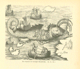
"Die Legende des heiligen Brandanus" St. Brendans Island is a
mystical island in the Atlantic. This fascinating image Wood engraving published ca 1900. n the reverse side is unrelated text. Image: 8.5 x 11 cm ( 3.3 x 4.3 ") $ 75-00 minus 30% Discount = $ 52.50 Order Nr. MAPCURIOSITY255921 |
|
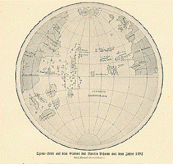
"Ozean Seite auf dem Globus
des Martin Behaim aus dem Jahre 1492" Very interesting map from the
globe of Martin Behaim with Europe and Africa on the right
side This map was made after Knrad Kretchmer and published 1900. Reverse side is printed. Diameter: 13 cm ( 5.1 ") Order Nr. ATLANTICMAP248793SOLD |
|
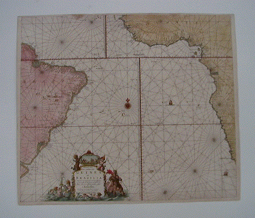
"Pascaarte vande Zee custen van Guinea, en Brasilia; Van Cabo de Verde, tot C. de vona EsperançA: en van R. de Amazones tot Rio de la Plata, alles op wassende graaden gestelt. t Amsterdam." Copper etching von Johannes van Keulen (1654-1711) for "De Groote Nieuwe Vermeerderde Zee Atlas ofte Water-werelt". Published ca 1710. Original hand coloring. This interesting map was made primarily for sailors. Notice the many windroses and ships in the Atlantic. On the right side is part of Africa and on the left this map shows the eastern part of Brazil with French Guiana and the mouth of the Amazon in the north. The coastline reaches as far south as Río de la Plata. A decorative cartouche adds to the attraction of this map. Map is shown photographed against a light background. Margins are narrow. Map has been mounted on stronger paper. There is a 5 cm repaired tear on left edge. Along the upper edge is a dark spot. General condition is Much Better than Good. 51.5 x 59.3 cm ( 20.2 x 23.3 ") $1870.00 Order Nr. SOUTHAMERICAMAP 2080 |
|
"Carte de L'Ocean Occidental Dressee pour Servir a l'Histoire Generale des Voyages" Hand-colored copper etching by Jacques Nicolas Bellin (1703-1772) Published in Paris, dated 1746 Very attractive hand coloring. Several horizontal and vertical folds to fit book size. One tiny hole in folds' crossing. Otherwise very, very good condition! 31,2 x 44,5 cm (ca. 12.3 x 17.5") Order Nr. ATLANTIC240481SOLD |
|
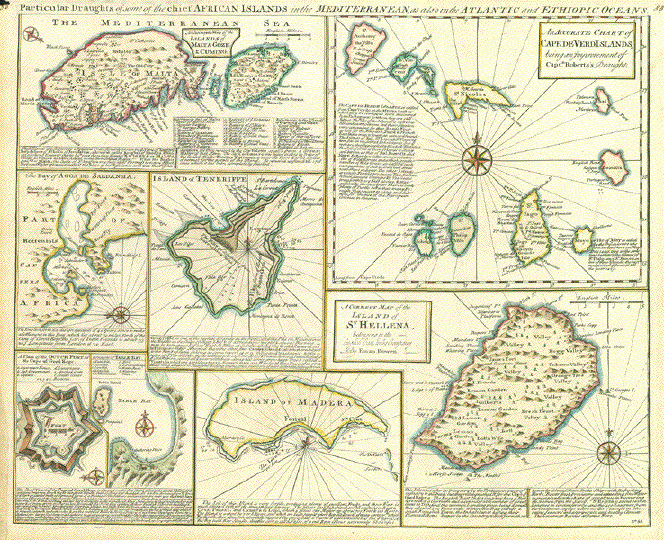
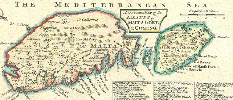
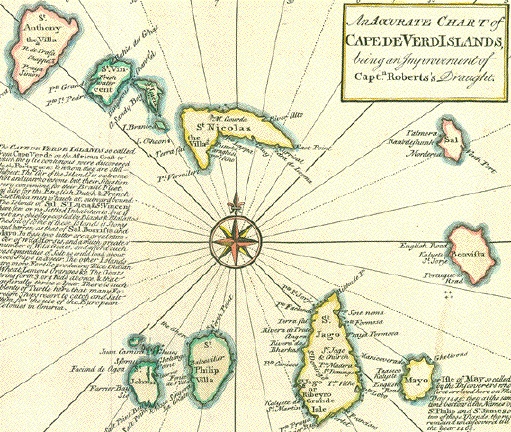
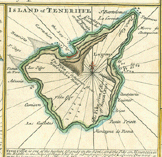
"Particular Draughts of some of the chief African Islands in the mediterranian, as also in the Atlantic and Ethiopic oceans". Copper engraving map by Emanuel Bowen(ca 1693-1767). From "A Complete System of Geography published in London ca 1750. Original hand coloring of the borders. 8 maps. "An accurate map of the islands of Malta Goze & Cuming" ; "An accurate chart of Cape de Verd Islands, being an improvement of Capt. Roberts's draught" ; "A correct map of the island of St. Hellena, belonging to the English East India Company" ; Island of Madera ; "A draught of Table Bay" ; "A plan of the Dutch fort at the Cape of Good Hope" ; "The Bay of Agoa de Saldanha" and "Island of Teneriffe." Signs of age and use in margins. Tiny piece of upper left margin corner is missing.Vertical centerfold. Map image: 35 x 43 cm (13.7 x 16.9") $ 390.00 minus 30% Discount = $ 273.00 Order Nr. ATLANTIC256874 |
|
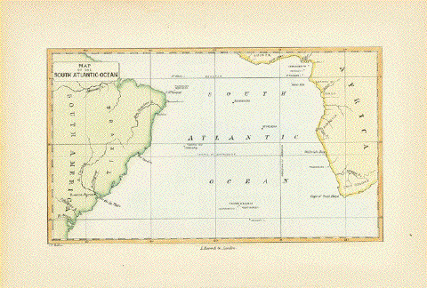
"Map of the South Atlantic Ocean" Hand-colored wood engraving by John Charles Melliss London, 1875 On the South American continent we see Brazil and some of the coast line of Argentina. Africa's West Cioast is shown from the Gulf of Guinea to the Cape. Lonely in the middle of the ocean: The island of St. Helena.What a distant place to park Mr. Napoleon! Light age toning in margins. Margins show some traces off age and use. 11,5 x 19,2 cm (ca. 4.5 x 7.5") $ 85.00 (Please see discount at top of this page. Here 30% = $ 66.00). Order Nr. ATLANTIC254761 |
|
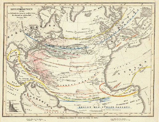
"Luftströmungen auf dem nordatlantischen Ocean im westlich. Gebiet der alten und im oestlichen Theiß der neuen Welt" Chart of air currents over the Atlantic Ocean west of Europe and Africa and east of North America. Steel engraving. Original hand coloring. Published in Schweinfurt, Germany. Ca. 1850 Only very light traces of age and use. 20,8 x 27,3 cm (ca. 8.2 x 10.7") $ 70.00 ATLANTICOCEANMAP240820 |
|
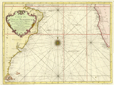
"Carte de L'Ocean Meridional .....". Copper etching by Bellin. Dated 1746. Modern hand coloring. The southern Atlantic with boarding continents is the subject of this interesting map showing wind directions. In the lower left is Tierra del Fuego. The South American coast reaches as far north as the mouth of the Amazon River. The African coast is shown from the Equator southward to the Cap de Bonne Esperance. In the lower left is a tiny piece of land titled: Cap de la Circonsision. St. Helana and Tristan d'Acuã are clearly shown along with other smaller islands. Upper margin has been widened. Almost invisible folds to fit book size. Otherwise Almost Very Good condition. 34.1 x 45.2 cm ( 13.4 x 17.8 ") Order Nr. ATLANTIC235164SOLD |
|
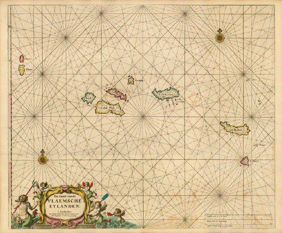
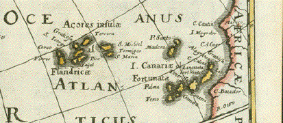
�Pas Caart van de Vlaemsche Eylanden" Azore Islands Copper etching from the Sea Atlas by Hendrick Doncker (1626-1699) Original hand coloring. Reverse side blanco. Amsterdam, 1659 The entire Azores Island group. Baroque cartouche held by a group of winged putti and Neptune. No sequence number. This is a RARE MAP! Doncker's maps are noted for their acuracy and authenticity. Printed on wondefully heavy paper. General age toning. Some spotting. Except for that the condition is almost very good. 43,2 x 53 cm (ca. 17 x 20.9") $ 2800.00 Order Nr. PORTUGALMAP238108 |
|
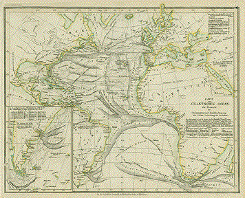
"Karte vom Atlantischen Ocean Zur
Uebersicht der Stroemungen und Handelsstrassen der Waerme
Verbreitung des Seebodens" Steel
etching from "Neuster Zeitungs Atlas. Alter und Neuer
Erdkunde" by J. Meyer, ca 1855. Map has a small repaired worm hole in upper right corner. Vertical centerfold. 21.5 x 27.3 cm ( 8.4 x 10.7 ") $ 75.00 Order Nr. ATLANTICMAP2241 |
|
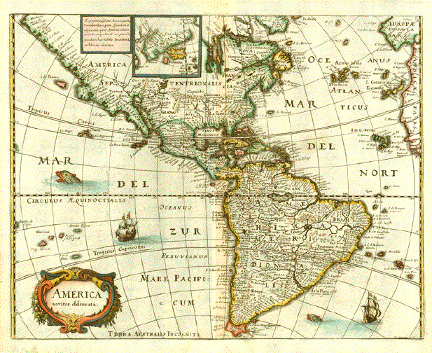
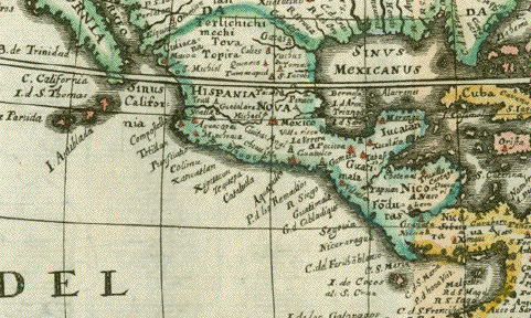
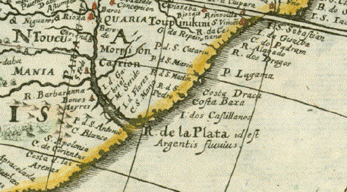
"America noviter delineata" Copper etching by Matthaeus Merian ( 1593 - 1650 ). This attractive map shows North abd South America based on the world map by Willem Blaeu. At the top of the map is a small inset showing Iceland and Greenland. The Azores, Canary Islands, and Cape Verde Islands are clearly shown off the coast of Africa. Notice how much of North America is yest to be discovered and mapped. Map has very pleasant contemporary hand coloring. This map was published in Frankfurt in 1638. Map has repairs in the upper
and lower margins on the centerfold that are 27.5 x 36.5 cm ( 10.8 x 13.9 ") Order Nr. SOUTHAMERICA250780SOLD |
|
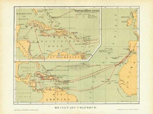
"Reisen des Columbus" Historical map of the Columbus travels across the Atlantic to the Caribbean islands. The lines are dated with the
trips Columbus made across the Atlantic.. Published in color
1881. Map image: 18 x 23 cm ( 7 x 9") $ 65.00 Order Nr. ATLANTICMAP253047 |
|
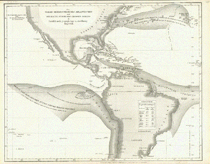
"Der Warme Meeresstrom des Atlantischen und Der Kalte Strom des Grossen Oceans" Very interestesting steel
engraving map of the warm and cold currents of the
Atlantic Image: 22.5 x 27.5 cm ( 8.8 x 10.8") $ 45.00 Order Nr. ATLANTICMAP254916 |
|
"Matin Beheim's Erdglobus, Oestliche Haelfte" Chromolithograph showing the
eastern half of the globe by Martin Beheim. Published 1881. Natural age toning. Image: 11 x 14 cm ( 4.3 x 5.5") $ 35.00 Order Nr. AFRICAMAP253283 |
|
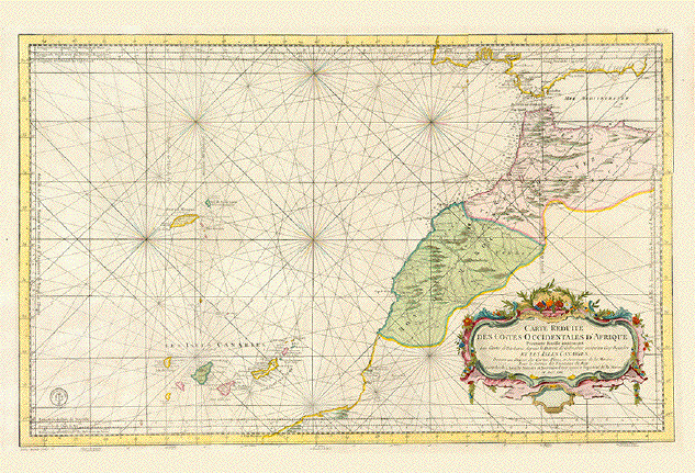
�Carte Reduite des Costes Occidentales d'Afrique Premiere Feuille contenent Les Costes de Barbarie depuisnle Detroit de Gibraltar jusqu'au Cap Bojador et les Isles Canaries..." Very attractive land and sea chart showing the Canaries and Madera in their exact location related to the African and European continents. Map of Gibraltar, Morocco, Canry Islands, Madera Type of print: Copper etching Color: Very fine original hand-coloring Author: Anonymous Publisher: Depot General de la Marine Where: Paris When: Dated 1753 Condition: Excellent Measures: 54,7 x 86,7 cm (ca. 21.5 x 37.1") $ 1300.00 minus 30% Discount = $ 910.00 Order Nr. ATLANTICMAP238262 |
|
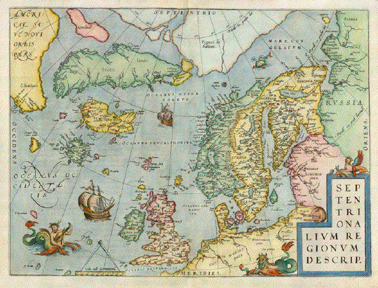
"Septentrionalium Regionum Descrip." Hand-colored copper etching from �Theatrum Orbis Terrarum" By Abraham Ortelius Antwerp. From the very rare First Edition, 1570 Verso: Latin Atlas page nr. 45 This is the much sought North Atlantic map from the �Theatrum" . Map shows Scandinavia. Finland, The Baltic Sea with its roundabout coastline of Germany, Poland, Lithuania, Latvia, Estonia up to Pechora in Russia. the North Sea coastline along Germany, the Netherlands, Belgium and France as far south as Dieppe. It shows the British Isles, All island groups in the North Atlantic, Greenland, Iceland, the first hint of the American continent in Nova Scotia. It also shows the mythical island of Frisland, which appeared on all North Atlantic maps up to the 1660ies and the North polar region. Adorned with sea monsters and sail ships this is one of the most collected maps ever. Along centerfold some very minor repairs. Otherwise excellent, especially for this First Edition exemplar. 35,7 x 48,7 cm (ca. 14 x 19.1") Order Nr. ATLANTIC237384SOLD |
|
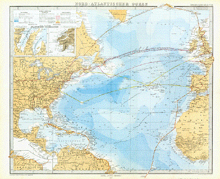
" Nord Atlantischer Ocean " Steel engraving by Herm. Burghaus for Stieler. Dated 1870. Interesting map showing some of the early Trans-Atlantic routes. In the upper left are two insets showing the east end ( Ireland ) and the west end ( Newfoundland ) of the Atlkantic Telegraph line. The overland telegraph lines are shown in red. Ocean depths are given. Map has a vertical centerfold. Condition is very good. 34.6 x 41.5 cm ( 13.6 x 16.3 ") $ 85.00 Order Nr. ATLANTIC236096SOLD |
|
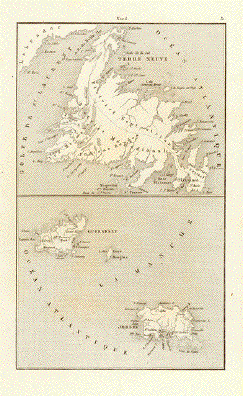
No Title Steel engraving published 1840
showing New Foundland in the upper 17.5 x 10 cm ( 6.8 x 3.9 ") $ 35.00 Order Nr. ATLANTICMAP252098 |
|
©Rainer Rauhut
|