Antique Maps of Portugal
Enjoy viewing a selection of our historical maps of Portugal. If you are looking for a special map, please contact us.
Antique Maps of Portugal
Enjoy viewing a selection of our historical maps of Portugal. If you are looking for a special map, please contact us.
Sale! Discount!
30% Discount on All maps with a PORTUGALMAP number on this page!
All Prices are US $.
Visit us at the following sites:
https://lovelyantiqueprints.com
twitter.com/philographikon2
|
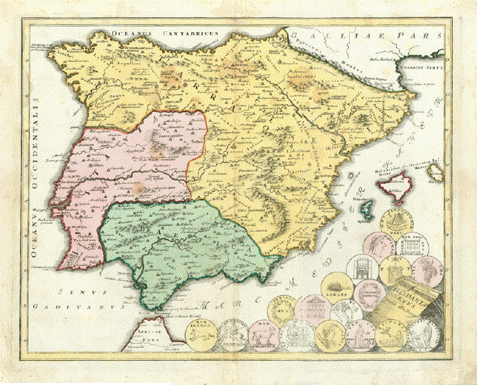
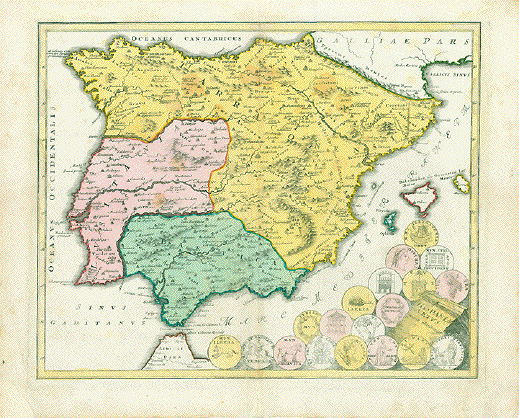
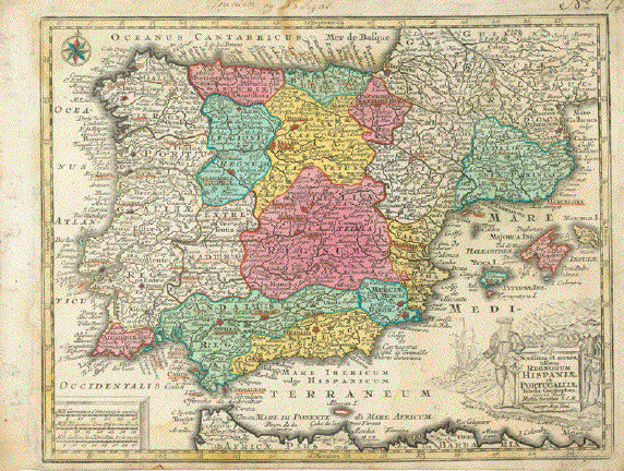
"Hispania Vetus Numis illustrabi" Map of ANTIQUE Spain and
Portugal (Iberia). This map shows the division of the Type of print. Copper etching Color: Original hand coloring Author: Samuel Faber (1657-1716) Publisher: Christoph Weigel (1654-1725) Published: Nuremberg, 1720 Edition: Weigel reissued "Atlas ScholastichodoeporicusÉ" which Faber originally published in 1716. Condition: Bright original hand
coloring. Image is well preserved except for a little
spotting. Map Image: 31 x 39 cm (ca. 12.2 x 15.4")" $190.00 Order Nr. ESPAÑAMAPA250157 |
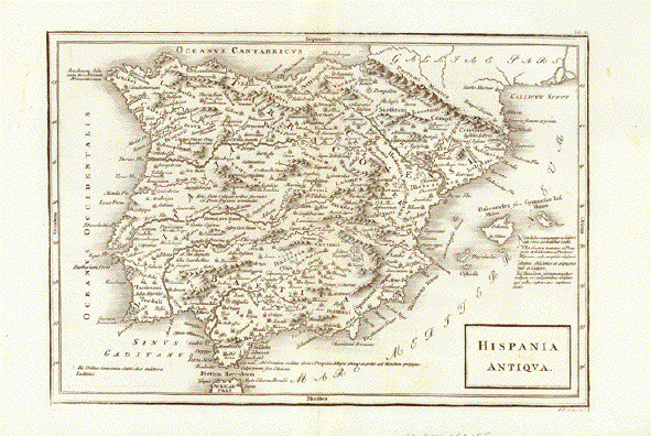
"Hispania Antiqua". Copper engraving by R. Seale, ca 1745.
Interesting historical map of Spain with the antique names of towns and topography.
Also given are the names of the early peoples of Spain.Map has a vertical centerfold. Fold has been reinforced. Small tear on upper and lower margin
edge on fold line have been repaired. Small crease in lower right corner margin. Small repair in left margin.MAP IMAGE: 20.2 x 29.7 cm ( 7.9 x 11.6 ")"
$ 120,00
Order Nr. ESPAÑAMAPA250155
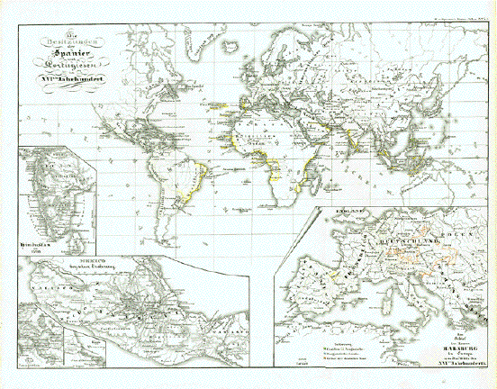
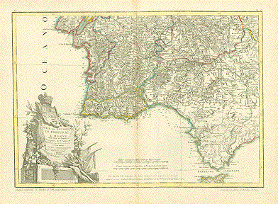
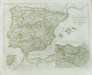
"Die Besitzungen der Spanier und Portugiesen im XVIten Jahrhundert"
The colonies of the Spanish and Portuguese in the 16th Century.
Original hand outline coloring showing the various lands and regions taken by the Spanish and Portuguese.
In the lower right is an inset showing the area belonging to the Habsburgs.
Published ca 1875. Very good condition.
Map image: 31 x 41.5 cm ( 12.2 x 16.3 ")
$ 110,00
Order Nr. ESPAÑAMAPA250122
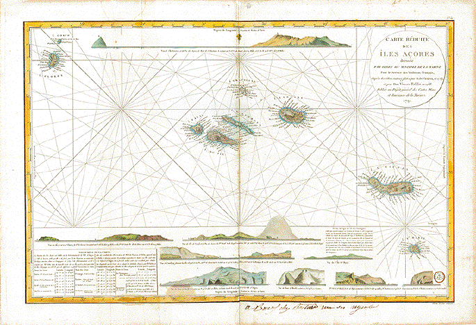
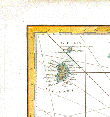
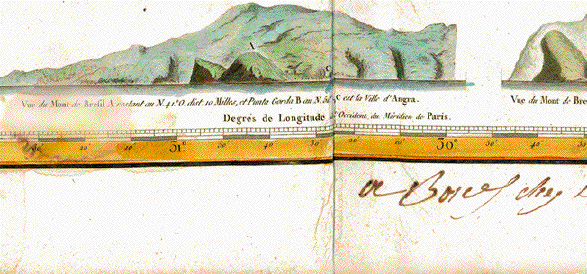
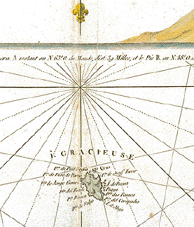
"Carte Reduite des Isles Acores dressée par ordre du Ministre de la Marine Pour le Service des Vaisseaux Francais d'après les Obersvations faites par M. de Fleurieu, en 1769 et par Don Vicente Tofino en 1788 Publiee au Depot général des Cartes, Plans et Journaux de la Marine 1791"
Hand-colored copper engraving of the Azore Islands. With 9 coastal elevation profiles.
Published by the French Marine. Paris, 1791
A very detailed and highly decorative map of the Azores.
There are, in the left half of map, some vertical pleats, which do not disturb the impression very much, because they do not interfere with any of the islands depicted. At the bottom of map, just left of centerfold and in and around border lines, is a small water stain. In lower right margin a few words black ink handwriting.
The overall appearance of map is very good. Vertical centerfold.
56 x 85 cm (ca. 22 x 33.5")
$ 1800.00
Order Nr. PORTUGAL/MAP248449
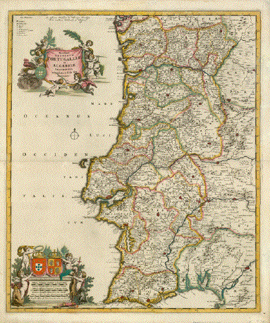
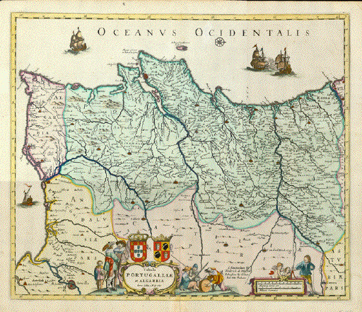
"Novissima Regnorum Portrugalliae et Algarbiae"
Copper etching from the atlas by Frederic de Wit.
Fine original hand coloring, coats of arms partially guilded. Fine title and mileage cartouches.
Amsterdam, 1680
Condition: Image very good. Centerfold and margins partially reinforced. Minor signs of age and use.
58 x 48,5 cm (22.8 x 19")
Order Nr. PORTUGALMAP 236806 SOLD
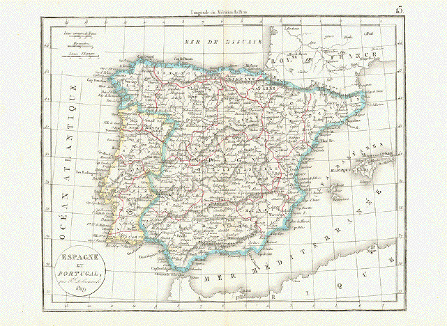
"Espagne et Portugal, par. F. Delamrche 1829"
Copper engraving by F. Delamarche. Published 1832.
Original outline coloring.Original vertical ceterfold to fit tlas size.
Fine, clean map image. Minor signs of age and use in margins.
Small repair on upper margin edge centerfold.26.5 x 33 cm ( 10.4 x 12.9 ")
$ 70.00
Order Nr. ESPAÑAMAPA242171
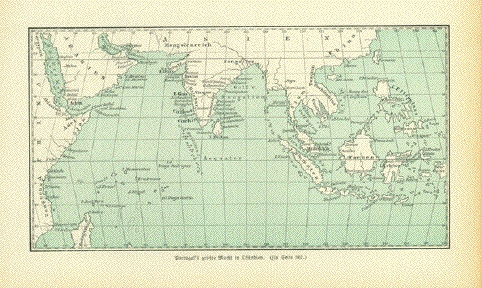
"Portugal's groesste Macht in Ostindien"
Wood engraving map published 1881 showing Portugal's colonization in East India.
On the reverse side is text about early Portuguese exploration in Asia.Map image: 10 x 18 cm ( 3.9 x 7")
$ 25.00
Order Nr. PORTUGALMAP252970
Iberian Peninsula. -"Das ander buch Hispanien Beschreibung mit seinen kuenigreichen / landschafften und Stätten irem von sitten / gebreuchen der alten und neuwen Spaniern"
(Spain (and Portugal), her kingdoms, landscapes, and towns, about the customs and traditions of ancient and modern Spaniards)
Miniature map, published in "Cosmographia" by Sebastian Münster (1488-1552)
Basel, 1553
German language. Related text print (German) below map. Verso text print is unrelated.
General age toning. Margins stained. Map image: very good condition.
Map: 7,5 x 13,5 cm (ca. 3 x 5.3")
Page size: 31 x 20 cm (ca. 12.2 x 7.8")
$ 90.00
Order Nr.ESPAÑAMAPA253185
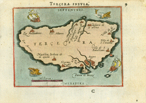
"Tercera Insula" (Terceira Island, Azores)
Hand colored copper engraving. Published in the pocket atlas by
Abraham Ortelius (1527-1598).On the reverse side is text about Spain in Latin.
The image is not printed exactly straight on the paper.Signs of age and usein the margins.
7.5 x 10.2 cm (3x4")
Order Nr. PORTUGALMAP1036SOLD
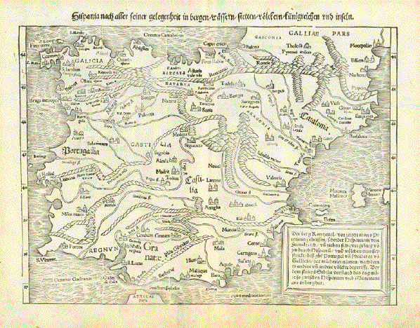
"Hispanien nach aller seiner Gelegenheit in bergen / wassern / stetten / voelkern / koenigreichen und inseln"
Woodcut Published in "Cosmographia"
By Sebastian Muenster (1488-1552)
Basel, 1553
This is a very early map of the Iberian Peninsula.What a nice map! Thanks to Sebastian Muenster! And his "Cosmographia"!
On one side of the reverse is a small, decorative emblem with idealistic scenes and persons.
Light General age toning (beautiful age patina). Otherwise impeccable!
25,2 x 34,3 cm (ca. 9.9 x 13.5")
$ 350.00
Order Nr.ESPANAMAPA252947
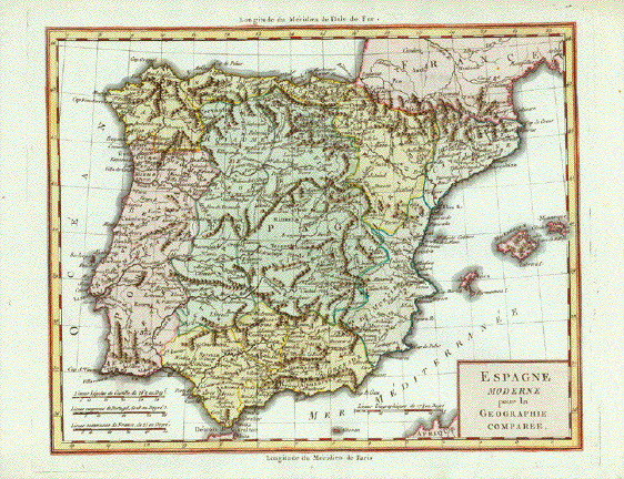
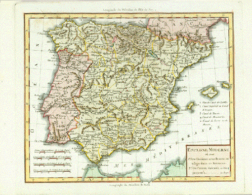
"Espagne Moderne pour la Geographie comparee"
Hand-colored copper engraving published ca 1785. Anonymous.
Fine map of Spain and Portugal with topographical details.
Very good condition.Map image: 22.5 x 28 cm (8.8 x 11")
$ 125.00
Order Nr. ESPAÑAMAPA252967
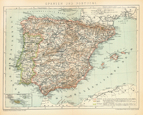
"Spanien und Portugal"
Wood engraving printed in color 1895. In the lower left corner is an inset of the Island of Madeira.
Vertical centerfold. Light age toning in margins.21 x 27.5 cm ( 8.2 x 10.8 ")
$ 25.00
Order Nr. ESPAÑAMAPA246190
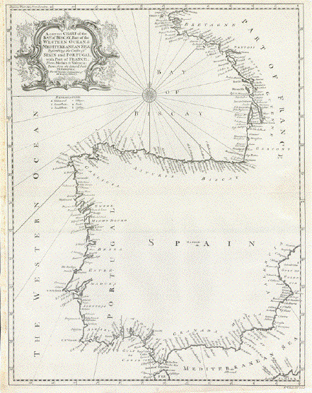
"A correct Chart of the Bay of Biscay, Part of the Western Ocean and Mediterranean Sea describing the Coasts of Spain and Portugal with Part of France from Morlaix to Valencia Done from the latest and best Discoveries�"
Portolan map of the Iberian Peninsula (and Western France including the Bretagne)
Type of print: Copper etching
Engraver and artist: Richard William Seale (1703-1762)
Published in: "Tindal's Continuation of Rapin's History"
London, ca. 1745
Condition: Several vertical and horizontal folds to fit smaller book size. These folds are well subdued and not disturbing. Lower margin has been widened in lower right. Some short tears have been repaired. Very clean and the image very well preserved.
47 x 37 cm (ca. 18.5 x 14.5")
$ 190.00
Order Nr.ESPAÑAMAPA238898
"Hispania Vetus Numis illustrabi"
Map of ANTIQUE Spain and Portugal (Iberia). This map shows the division of the Iberian Peninsula during Roman times. All place names are in Latin. In lower right corner coins are shown, that were currency in Iberia during the Roman Empire.
Type of print. Copper etching
Color: Original hand coloring
Author: Samuel Faber (1657-1716)
Publisher: Christoph Weigel (1654-1725)
Published: Nuremberg, 1720
Edition: Weigel reissued "Atlas Scholastichodoeporicus�" which Faber originally published in 1716.
Condition: Bright original hand coloring. Image is well preserved except for a little spotting. Left and right margins have water stains, which show little from the front, but clearly agains a source of light. Lower left and right margin corners have been replaced. Small tears. Other traces of age and use in margins have been repaired. In general, and because image is hardly affected by damage, the condition may well be described as good.
31 x 39 cm (ca. 12.2 x 15.4")
$ 180.00
Order Nr.ESPAÑAMAPA238897
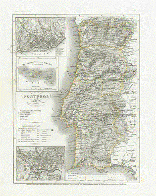
"Portugal und die Azoren 1849".
Steel etching by Renner from "Neuster Zeitungs Atlas. Alter und Neuer Erdkunde" by J. Meyer, ca 1850.
Original outline coloring.Detailed map of Portugal with a city-plan inset of Lisabon at the top left.
On the left center is an inset of the Azores and the inset in the lower left is the city of Porto.Clean map with a strong impression.
24.6 x 18.3 cm ( 9.6 x 7.2 ")
$ 110.00
Order Nr. PORTUGALMAP250341
"Hispania" Steel etching from "Neuster Zeitungs Atlas. Alter und Neuer Erdkunde" by J. Meyer, ca 1860. Original outline coloring.
Very detailed map of the Iberian Peninsula. The area outlined in blue is Lusitania - Portugal at the time.
Clean map in good condition.
21 x 26.3 cm ( 8.2 x 10.3 ")
$ 70.00
Order Nr. ESPAÑAMAP1647
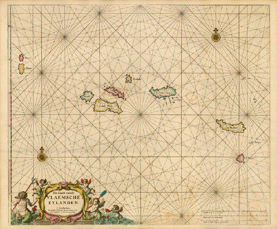
�Pas Caart van de Vlaemsche Eylanden" Azore Islands
Copper etching from the Sea Atlas by Hendrick Doncker (1626-1699)
Original hand coloring. Reverse side blanco.
Amsterdam, 1659
The entire Azores Island group. Baroque cartouche held by a group of winged putti and Neptune.
No sequence number. This is a RARE MAP! Doncker's maps are noted for their acuracy and authenticity.
Printed on wondefully heavy paper. General age toning. Some spotting. Except for that the condition is almost very good.
43,2 x 53 cm (ca. 17 x 20.9")
$ 2800.00
Order Nr. PORTUGALMAP238108
"Tabula Portugalliae et Algarbia"
West-oriented copper etching by Frederic de Wit.
Very nice hand coloring including the two cartouches (title and mileage) and the sailships
Amsterdam, 1680
Very nice hand coloring
Printed ca. 1690 in Amsterdam
Condition: Image very good. Lower centerfold has been backed. Minor traces of age and use in margins.
46,5 x 55,7 cm (ca. 18.3 x 22")
Order Nr.PORTUGALMAP 236805 SOLD
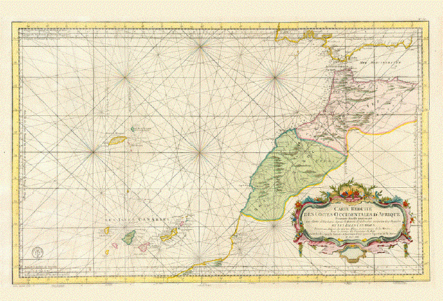
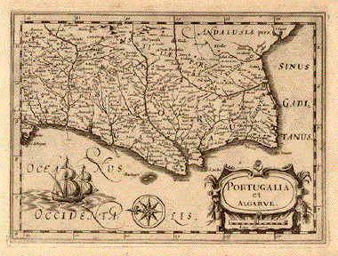
�Carte Reduite des Costes Occidentales d'Afrique Premiere Feuille contenent Les Costes de Barbarie depuisnle Detroit de Gibraltar jusqu'au Cap Bojador et les Isles Canaries..."
Very attractive land and sea chart showing the Canaries and Madera in their exact location related to the African and European continents. Map of Gibraltar, Morocco, Canry Islands, Madera
Type of print: Copper etching
Color: Very fine original hand-coloring
Author: Anonymous
Publisher: Depot General de la Marine
Where: Paris
When: Dated 1753
Condition: Excellent
Measures: 54,7 x 86,7 cm (ca. 21.5 x 37.1")
$ 1300.00 minus 30% Discount = $ 910.00
Order Nr. ATLANTICMAP238262
�De Cust van Barbaryen van C. Blanco tot C. de Geer"
MOrocco - Atlantic coastline from Cape Blanco to Cape Geer. Map centers on Safi and Essauoira
�De zuydhoek van't Eylandt Fayal"
Faial - Azores
�De Reede voor de Stadt Angra in't eylandt Tercera"
Angra Azores
�De Eylanden van Madera en Porto Santo"
Madeira and Porto Santo - Azores
5 copper etchings in original hand coloring one one large map.
by Pieter Goos.(1616-1675)
Published in Zee Spiegel - (Mirror of the Sea) with nr. �57"
Amsterdam, 1666
The original hand coloring is very attractive! However the map has some remarkable traces of use. There are ink marks, which we show for you to see. The map had once been mounted. There are remnants of paste on reverse side. Map had been folded. These folds are a bit visible. General age toning. Some spotting. Small reapired tear in lower margin on centerfold. Although this map has the mentioned faults, it is still quite attractive, especially because of its beautiful original hand coloring.
41,5 x 51 cm (ca. 16.3 x 20")
$ 1100.00
Order Nr.NORTHAFRICAMAP238101
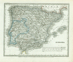
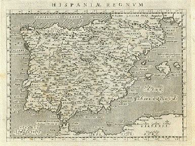
"Novissima et accura tabula Regnorum Hispaniae et Portugalliae"
Copper engraving map by M. Seutter. Published by Lotter in Augsburg ca 1660.
Original hand coloring.Map is spotted and stained from age. Crease in lower left margin corner.
20 x 25 cm ( 7.8 x 9.8 ")
$ 55.00
Order Nr. ESPAÑA242272
"Espagne Moderne ou sont les divisions actuellement en usage dans ce Royaume...."
Copper engraving map ca 1780. Anonymous. Attractive hand coloring.
Map image: 22 x 27.5 cm (8.6 x 10.8")
$ 125.00
Order Nr. ESPAÑAMAPA252979
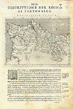
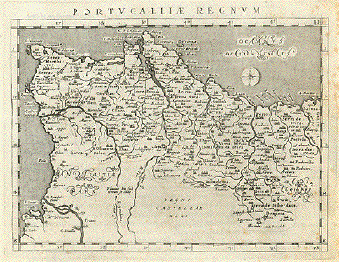
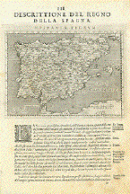
"Descrittione Del Regno di Portugallo" (Portugal)
Copper etching published in �Geografia cioe Descrittione Universale della Terra" Gio. Battista & Giorgio Galignani Fratelli. Venice, 1598
First edition in Italian prepared by Giovanni Antonio Magini (1555-1617)
General age toning. Traces of age and use. Some spotting mostly outside map in margins.
Sheet size: 28.5 x 19 cm (11.2 x 7.5")
Map size: 12.5 x 17.2 cm (4.9 x 8.8")
$ 300.00
Order Nr. PORTUGALMAP235803
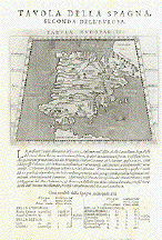
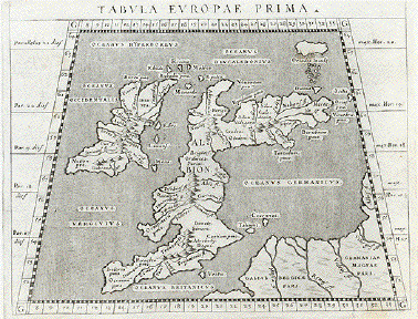
"Tavola della Spagna, Seconda dell'Europa" - Spain and Portugal (Iberian Peninsula)
Copper etching after Claudius Ptolemaeus published in �Geografia cioe Descrittione Universale della Terra" Gio. Battista & Giorgio Galignani Fratelli. Venice, 1598
First edition in Italian prepared by Giovanni Antonio Magini (1555-1617)
Clean. Only minimal traces of age and use.
Sheet size 27.5 x 19 cm (10.8 x 7.5")
Each of the maps: 13 x 17.2 cm (5.1 x 8.8")
$ 400.00
Order Nr. ESPAÑAMAPA235806
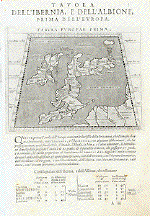
Reverse Side:
"Tavola dell'Ibernia, e dell'Albione, Prima dell'Europa" - Irelandf and Great Britain (England, Ireland and Scotland)
Copper etching after Claudius Ptolemaeus published in �Geografia cioe Descrittione Universale della Terra" Gio. Battista & Giorgio Galignani Fratelli. Venice, 1598
First edition in Italian prepared by Giovanni Antonio Magini (1555-1617)
"Discrittione Del Regno Della Spagna" Spain and Portugal (Iberian Peninsula)
Copper etching published in �Geografia cioe Descrittione Universale della Terra" Gio. Battista & Giorgio Galignani Fratelli. Venice, 1598
First edition in Italian prepared by Giovanni Antonio Magini (1555-1617)
General age toning. Minor traces of age and use, especially in lower right margin of text.
Sheet size: 28.5 x 19 cm (11.2 x 7.5")
Map size: 12.5 x 17.2 cm (4.9 x 8.8")
$ 380.00
Order Nr.ESPAÑAMAPA235807
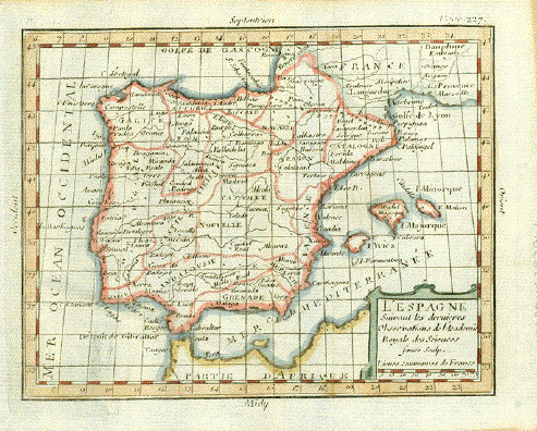
"L'Espagne suivant les derniers Observations de lÄAcad. Royal des Sciences.."
Copper engraving map by Faure and Claude Buffier(1661-1737) in Paris.
Published ca 1739. From "Geographie Universelle: Exposee dans les differentes Metodes qui
peuvent abreger l'etude & faciliter l usage de cette science..."Hand coloring. Very minimal signs of age and use. Two vertical folds to fit original book size.
Map image: 13.5 x 17.5 cm ( 5.3 x 6.8")
$ 95.00
Order Nr. ESPAÑAMAPA252966
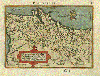
"Portugalliae que olim Lusitania novissima et exactissima descriptio." Copper etching in modern coloring from the pocket atlas by A. Ortelius. Antwerp, Latin edition 1587
This west-oriented map of Portugal has many of the antique names of towns and cities. Notice how many of the rivers are shown. A decorative sailing vessel is in the Atlantic. In the lower left corner is Sevilla. Backside4 is printed in Latin with text about Andalucia.
Some very minor spotting in margins and browning on margin edges.
Order Nr. PORTUGALMAP1037SOLD
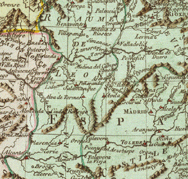
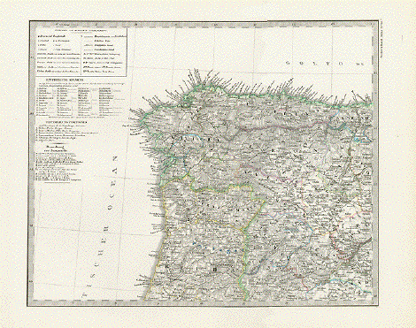
No Title. Steel engraving from Stieler´s Atlas 1871. Original outline coloring.
Very detailed map of northwestern Spain and norther Portugal. The map reches as far south as Paredes, Mondego and Coimbra in Portugal and as far east as Santeander in spain. In the lower right corner is Madrid and Illescas.
Map has a vertical centerfold. Conditin is good.
30.5 x 37.5 cm ( 12 x 14.7 ")
$ 90.00
Order Nr. ESPANAMAPA236417
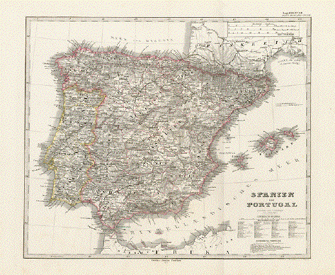
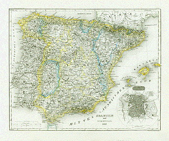
"Spanien und Portugal" Steel engraving by C. Poppey from Stieler´s Atlas dated 1871. Original outline coloring.
Detailed map of Spain and Portugal with the divisions of the 48 provinces and the 6 provinces of Portugal.
Vertical centerfol with small repair on centerfold in lower margin.
31 x 36.5 cm ( 12.2 x 14.3 ")
$ 70.00
Order Nr. ESPANAMAPA236418
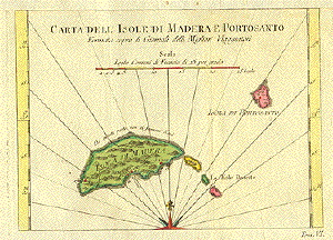
"Carta dell'Isole di Madera e Portosanto". Copper etching by Bellin from the Italian edition of his atlas. Ca. 1750. Modern hand coloring.
Fanning from a windrose are the islands of Madeira, Porto Santo and the group of Desertas Islands. Funchal and smaller settlements are shown on Madeira.
Map has overall light toning and folds to fit atlas size. Upper margin has been added. General condition is otherwise Very Good.
15.2 x 21.1 cm ( 5.9 x 8.3 ")
$ 85.00
Order Nr. PORTUGALMAP1026
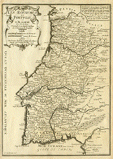
"Les Royaumes de Portugal et D'Algarve". Copper etching by Nicolaus de Fer, dated 1705.
This detailed Portuguese map shows the countryabout 1700. Some of the earlier regions are named on the map. At the very top is Pontevedra and at the bottom is Cadiz. Notice how clearly the major rivers and their territories are shown.
Side margins are narrow. There are some minimal spots in margins, otherwise condition is fine.
35.5 x 25.5 cm ( 13.9 x 10 ")
$260.00
Order Nr. PORTUGAL MAP 1040
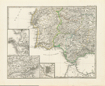
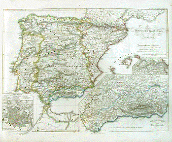
No Title
Steel engraving 1870. From "Hand-Atlas über alle Theile der Erde und über das Weltgebäude" by Adolf Stieler.
On the left side is a detailed inset of Cadiz. In the lower left is Lisabon and the surrounding area. In the lower center is a plan of Madrid.
Original outline coloring. Vertical centerfold. Very good condition except for a small repaired tear on centerfold in lower margin.
30.5 x 37 cm ( 12 x 14.5 ")
$ 145.00
Order Nr. ESPAÑAMAP235791
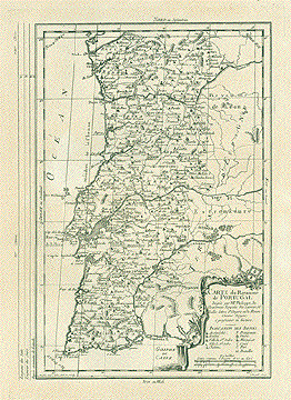
"Carte du Royaume de Portugal". Copper engraving by Herault after Moithey for Mr. Philippe ca 1750.
Fine map of Portugal with the royal divisons of the time.
Clean map with a horizontal centerfold. Wide margins.
37.2 x 25 cm ( 14.6 x 9.8 ")
$ 220.00
Order Nr. PORTUGALMAP1051
"Royaume de Portugal". Copper engraving published by Chez le Rouge in Paris ca 1750. Hand outline coloring.
Along the Atlantic coast, this map reaches from Villagarcia and San Tomas in the north all the way south to Cap S. Vencent and then east to the mouth of the Guadalquivir River. In the upper right corner is Benavente and La Vega.
Map has a horizontal centerfold. Very light browning along centerfold.
27.5 x 20.7 cm ( 10.8 x 8.1 ")
$ 90.00
Order Nr. PORTUGALMAP1050
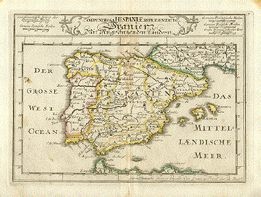
"Compendiosa Hispaniae Representatio Spanier Mit Angraenzenden Laendern" Copper engraving ca 1760. Original hand outline color.
Map shows political divisions of the time as well as major rivers.
Map has vertical fold. A few scattered spots. Upper margin corners are browned. Small tear on centerfold on lower margin edge.
15 x 21 cm ( 5.9 x 8.2 ")
$ 125.00
Order Nr. ESPAÑAMAP1586
"Partie Septrionale Du Royaume De Portugal". Copper engraving by Robert de Vaugondy, dated 1749.
Map reaches from Dondamar and Moserte in the north to Barlenga and Lourihan in the south. In the upper right corner is Pardonella and Nuez. In the lower right corner is Alcantara and Venta Camarera.
Light browning on margin edges. Bing holes on left margin edge.
16.2 x 19.7 cm ( 6.3 x 7.7 ")
$ 140.00
Order Nr. PORTUGALMAP1049
No Title. Copper engraving ca 1770. Some outline coloring.
This map shows northern Portugal from Cabo de Espichel and Troya in the south to Feira in the north. The Tajo River is in the lower center of the map. Some of the early roads are shown, some probably as postal routes. In the lower right is the Spanish city of Merida. In the upper right are the Spanish towns San Pelayo and Matilla. Map has very wide margins. On the lower margin edge are some small worm tracks. Clean.
32.2 x 43.2 cm ( 12.6 x 17 ")
$ 185.00
Order Nr. PORTUGAL1MAP053
"Mapa Dos Reyos De Portugal E Algarve Feita sobre as Memorias Topografica de D. Vasque de Cozuela as do P. Lacerda....." Copper engraving by Berthoult for Rizzi Zannoni ca 1740. Original hand outline coloring.
This detailed topographical map shows southwest Portugal and part of southern Spain. At the top of the map on the Atlantic Ocean is Cintra. In the center is Moura and Aroche. In the upper right are Talarubias and Garabaivella. In the lower right are Fuengirola and Marbella. At the bottom of the map is Ceuta and Tangiers.
Map has vertical centerfold with some light browning along fold line. A few minor spots.
30 x 42.5 cm ( 11.8 x 16.7 ")
$ 240.00
Order Nr. PORTUGALMAP1052
"Spanien und Portugal 1849" Steel etching by H. Bornmueller from "Neuster Zeitungs Atlas. Alter und Neuer Erdkunde" by J. Meyer, ca 1860. Original outline coloring.
Very detailed map of the Iberian peninsula. In the lower right is a detailed plan of Madrid.
Clean map in fine condition.
21 x 26.3 cm ( 8.2 x 10.3 ")
$ 90.00
Order Nr. ESPAÑAMAP1637
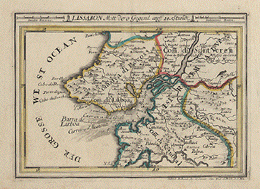
"Lissabon Mitt dero Gegend auff 10 Stundt. Copper engraving by Gabriel Bodenehr, 1705. Original outline coloring.
Very detailed map of Lissabon and the surrounding area. Map extends from Paniche and Paynogo in the north to Molinos and the Rio Codaon in the south. In the center of the map is the mouth of the Tajo River. The map reaches as far east as Chamusca at the top of the map to Cabrela in the lower right.
Map has hardly visible vertical fold to fit original book size. Very wide side margins. A few minimal spots in margins.
15.7 x 22.2 cm ( 6.1 x 8.7 ")
$ 260.00
Order Nr. PORTUGALMAP1042
"Portugalia et Algarve". Copper engraving from the Mercator /Hondius series published in 1606.
The north of Portugal is on the left side of the east-oriented map. The Atlantic coast extends from Baiona and Guardia in the north to San Lucar in the south. The map reaches as far east as Placentia, La Boveda and Merida. A historic sailing vessel and windrose add to the historicity of this map.
Map has overall age-toning. Browning on margin edges and a few minimal spots.
18 x 24.5 cm ( 7 x 9.6 ")
$ 225.00
Order Nr. PORTUGALMAP1043
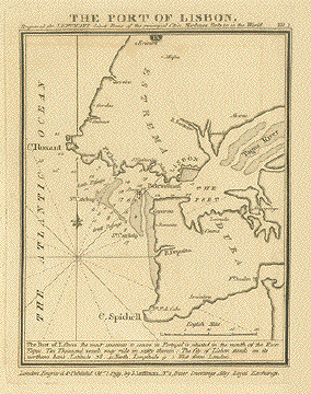
"The Port of Lisbon" Copper etching engraved for Luffman's "Select Plans for the Principal Cities, Harbours and Forts in the World", dated 1799.
Detailed plan showing the harbor and surrounding area of Lisbon.
Overall light age toning. Three binding holes on left margin edge. General condition is otherwise Almost Very Good.
15 x 12 cm ( 5.9 x 4.7 ")
Order Nr. PORTUGALMAP10330 SOLD
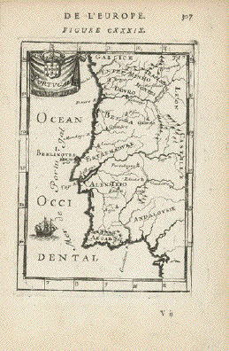
"Portugal" Copper engraving by Allain Mallet for "Descrption de L'Univers) published in Paris, 1683.
Map extends from Galicia in the north to Andalucia and the mouth of the Guadiana River in the south. On the right is part of Leon and Castilla. Notice the coat-of-arms in the title cartouche. Backside is printed with text (in French) about Portugal.
Map has light age toning and very minor signs of age and use..
14 x 9.8 cm ( 5.5 x 3.8 ")
$ 90.00
Order Nr. PORTUGALMAP254415
"Das Emirat von Corduba bis zum Untergang der Ommijaden und die christlichen Reice im Norden der iberischen Halbinsel von 711 bis 1028." Copper engraving by Johann Carl Ausfeld for Dr. Karl von Spruner's "Historisch-Geographischer Hand Atlas". Published in Gotha, 1846. Original hand outline coloring.
This map shows the Emirat of Cordoba from 711 to 1028. The map has many very historical names, especially the Arabic, Gothic and Celtic names of the time.
Map image is clean. Some light scattered spotting in Beige outline and in margins.
32.3 x 39.8 cm ( 12.7 x 15.6 ")
$ 250.00
Order Nr. ESPAÑAMAP1606
"Die iberische Halbinsel seit dem Anfange des XVIten Jahrhunderts 1479. Copper engraving by W. Alt for Dr. Karl von Spruner's "Historisch-Geographischer Hand Atlas". Published in Gotha, 1846. Original hand outline coloring.
Interesting map of Iberian Penninsula at the beginning of the 15th Century, 1479. In the lower left is a small inset of Lissabon and surrounding area. In the lower right is a detailed inset of Navarra and the Vascongadas.
Map has a strron image. The are a few minor scattered spots. Light browning on margin edges.
30.5 x 41 cm ( 12 x 16.1 ")
$ 250.00
Order Nr. ESPAÑAMAP1607
"Die iberischer Halbinsel von 1257 bis 1479" Copper engraving by C. Stier for Dr. Karl von Spruner's "Historisch-Geographischer Hand Atlas". Published in Gotha, 1846. Original hand outline coloring.
Detailed historical map of the time from 1257 to 1479 on the Iberian Penninsula. In the lower left is an inset with a city plan of Granada. In the lower right is an inset of Andalucia and Granada. Right above this inset is one of northern Catalunya with the coast near Ampuria Girona.
Some light scattered spotting. Left margin is narrow. Light browning on margin edges.
31 x 42 cm ( 12.2 x 16.5 ")
$ 250.00
Order Nr. ESPAÑAMAP1608
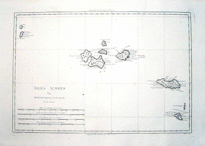
"Isles Açores" Copper engraving by Andre after Rigobert Bonne(1727-1795) Published in Paris ca 1780.
From Corvo and Flores Island in the upper left to St. Maria in the lower right, this map show are the major islands of the Azores.
Two hardly visible vertical folds to fit original book size. Light crease in middle of map. Some small scattered spots in the center of the map and a few in margins. Small rubbed area in upper right corner. Map has a light toning not shown in this photo.
23.5 x 35 cm ( 9.2 x 13.7 ")
$170.00
Order Nr. PORTUGALMAP1048
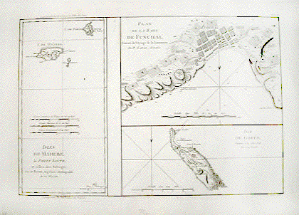
Left image: "Isles De Madere, de Porto Santo et celles des Salvages. Upper right image:Plan de La Rade De Funchal Extraite du Voyage de la Louisiane du P. Laval, Jesuite. Lower right image:Isle De Gorée, Située à la Côte Sud du Cap Verd." Copper engraving by Andre for Rigobert Bonne(1727-1795) Published in Paris ca 1780.
On the left side are the islands of Madeira and Porto Santo At the very bottom is the Isles Salvagess.. In the upper right is a very detailed plan of the Harbor of Funchal. In the lower right is the island of Goree in the Cape Verde Islands.
Hardly visible vertical fold to fit original book size. Light browning on margin edges. In the upper area between Porto Santo and Funchal is a small line in the paper.
23.3 x 34.6 cm ( 9.1 x 13.6 ")
Order Nr. PORTUGALMAP1045 SOLD
"Royaume De Portugal" Copper engraving by Andre for Rigobert Bonne(1727-1795) Published in Paris ca 1780.
Very detailed map of Portugal extending from Pontevedra in the north to the mouth of the Guadalquiver River. On the right side is part of Extremadura with Placentia and Merida. In the upper right is Benavente.
Map has a stronger impression than shown on this photograph. Hardly visible horizontal fold to fit original book size. A few very minor scattered spots and light browning on margin.
34.5 x 23.5 cm ( 13.5 x 9.2 ")
$ 120.00
Order Nr. PORTUGALMAP1047
"Regnorum Hispaniae et Portugalliae Tabula generalis." Copper etching by Tobias Conrad Lotter ( (1717-1777) after Tobias Lobeck for the "Atlas Geographicus portabilis" (Pocket-size atlas) published 1760-1762. Original hand coloring.
Fine little map of the Iberian Penninsula, southern France and northern Africa.
Light browning in upper and lower right margin corners.
9.4 x 12.2 cm ( 3.7 x 4.8 ")
$ 130.00
Order Nr. ESPAÑAMAP1565
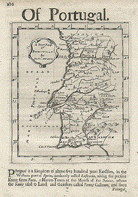
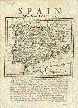
"Of Portugal". Copper etching from "Geography rectivied" by Robert Morden. London, 1688.
Verso text about Spain in English. Condition is Very Good.
13 x 11 cm ( 5.1 x 4.3")
$ 125.00
Order Nr. PORTUGALMAP1027
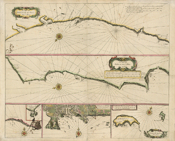
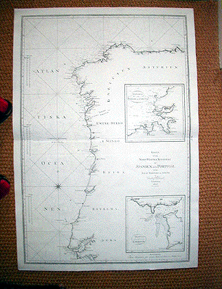
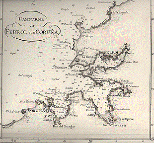
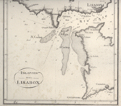
"Karta Oefver Nord Westra Kusterne Af Spanien och Portugal Efter Atlas Maritimo de España" Copper engraving by Fr. Akrel after Gustaf Klint of Stockholm, dated 1803. SELDOM!
This map shows the Mar Cantábrica at the top beginning on the right with Cabo de Peñas and Aviles. It reaches as far south as St. Ybes and Troja south of Lisabon. In the upper right is a detailed inset titled "Hamnarne Vid Ferrol och Coruña". This shows very great detail including the depths of the water. In the lower right is an inset titled "Inloppen Till Lisabon"also with great detail. In the sea is a windrose and compass measurements.
Map has a horizontal fold. There are a few creases that were in the thick paper. In the lower right is some very light scattered spotting.
96 x 64.3 cm ( 37.7 x 25.3 ")
$ 1790.00
Order Nr. ESPAÑA MAP 1590
Spain and Portugal
Copper etching by Hermann Moll (1678-1732)
Published ca 1710.Text below image and on backside is in English.
Image is clean and strong. Print has repaired tear in text area.
Browning on margin edges.
Right margin is reinforced. Condition is just Good.Map image: 15.5 x 18 cm ( 6.1 x 7 ")
Page size:31.5 x 20.5 cm ( 12.4 x 8 ")$ 140.00
Order Nr. ESPAÑAMAP1553
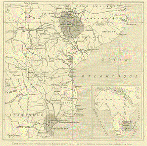
"Carte Des Possessiones Portugaises En Afrique Orientale. - Les parties teintéss représentent les territoires en Litige." Wood engraving from "Le Monde Illustré" , ca 1890.
Map shows the east coast of Africa from the Lurio river in the north south to the Maputo river. In the lower left is Pretoria and Potchefstroom. In the lower right is an inset showing the area of the map in relation to all of Africa.
Map has text and small images on backside. General condition is otherwise Very Good.
19.5 x 19.8 cm ( 7.6 x 7.8 ")
$ 40.00
Order Nr. AFRICAMAP1606
|
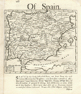
"Of Spain". Copper etching from "Geography rectivied" by Robert Morden. London,1688. Left margin widened. Verso text description of France. The condition is good. 12.5 x 14 cm ( 4.9 x 5.5") $ 150.00 Order Nr. ESPAñAMAP1497 |
MAPS: Maps of many countries from the great cartographers of the last 500 years.
PRINTS OF THE ENTIRE WORLD: Antique town and city views.
CARNEVAL, CARNIVAL, FASCHING, MARDI GRAS
GASTRONOMY -Eating and Drinking
READY TO HANG - Prints and paintings ready to hang!
© Rainer Rauhut