|
Alte Landkarten von Deutschland (Seite 7) Antique Maps of Germany (Page 7) This is a selection of our historical maps of Germany. There are several pages more. Click the link at the bottom of the page to see more. If you are looking for a particular map please contact us. If you want to know if a certain town or city is on one of our maps, please ask. Sale! Discount! 30% Discount on All maps with a DEUTSCHLAND number on this page! Visit us at the following sites: https://lovelyantiqueprints.com twitter.com/philographikon2 |
|
"Waldeck Comitatus". Copper etching in very pleasant modern coloring. By Peter Kaerius (1571-1646). Amsterdam, ca 1620. Verso text in Latin. Waldeck is found a bit to the southeast of center. In the southeast is Bissenhausen and the Schwalm River, in the northest is Dahlheim. Under the cartouche in the west is Meschede. In the southwest corner is Schmallenberg and Bracht. Map has a small wormhole in lower organge margin. Very minor spotting in margins. Tiny repaired tear on lower margin edge. Condition is almost Very Good. 14.2 x 19.2 cm ( 5.6 x 7.5 ") $ 180.00 minus 30% Discount = $ 126.00 Order Nr. DEUTSCHLAND256717 |
|
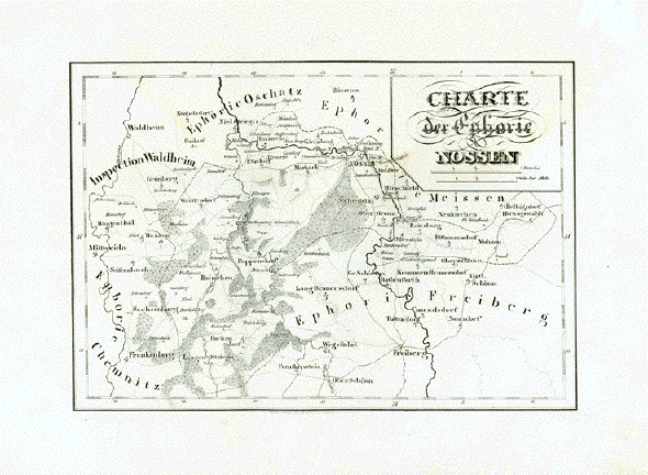
Nossen. - "Charte der Euphorie Nossen" Lithographie aus "Atlas des Königreichs Sachsen in 26 Karten" Von Friedrich Adolph Lüdicke und Carl Heinrich von Zobel Verlag: F.W. Godesche Herausgeber: Lithographisches Institut Pönicke & Sohn Leipzig, 1830 Guter Erhaltungszustand. Breite Margen. 18,8 x 27,5 cm $ 100.00 Order Nr. DEUTSCHLAND253122 |
|
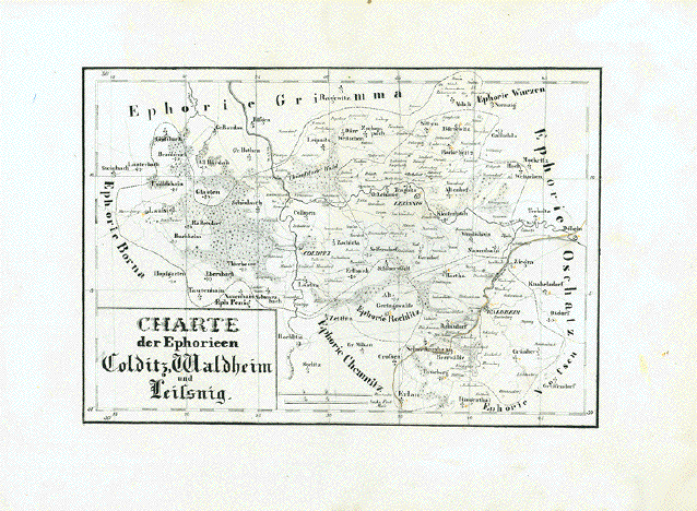
Colditz, Waldheim, Leisnig. - "Charte der Ephorien Colditz, Waldheim u. Leissnig" Lithographie aus "Atlas des Königreichs Sachsen in 26 Karten" Von Friedrich Adolph Lüdicke und Carl Heinrich von Zobel Verlag: F.W. Godesche Herausgeber: Lithographisches Institut Pönicke & Sohn Leipzig, 1830 Guter Erhaltungszustand. Breite Margen. Rechte untere Margenecke mit Beschmutzung vom Blättern 18,7 x 27,5 cm $100.00 Order Nr. DEUTSCHLAND253124 |
|
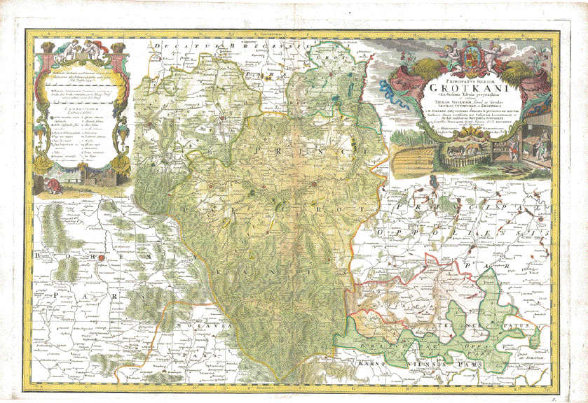
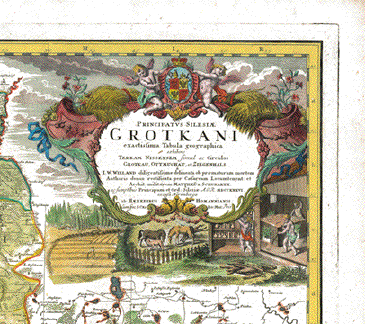
"Principatus Silesiae Grotkani exactissima Tabula geographica exhibens Terra Nissenem simul ac Circulos Grotkau, Ottmuchau et Ziegenhals a I.W.Wieland diligentissime delineata ob praematuram mortem Authoris denuo rectificata per Caesareum Locumtenent et Archit. militarem Matthaeo a Schubarth ac sumptibus Principum et Ord. Silesiae. A.O.R. MDCCXXXVI excusa Norimbergae ab Haeredibus Homannianis�" Fürstentum Grotkau mit Neisse im Zentrum, Grotkau, Patschkau, Ziegenhals, links noch Münsterberg und Frankenstein, Habelscherd, unten noch Jägerndorf (heute Tschechien). Sehr detaillierte und dekorative handkolorierte Kupferstichkarte nach Zeichnung von Johann Wilhelm Wieland (? - 1736) und nach dessen Tod ueberarbeitet von Matthaeus Schubart (? - 1758). Aus dem "Atlas Silesiae". Herausgeber: Homann Erben, Nürnberg. Die Karte ist 1736 datiert und gedruckt. Der Atlas mit insgesamt 18 Kupferstichkarten ( zwei Übersichtskarten und 16 Fürstentuemer) im Gross-Folio-Format wurde insgesamt aber erst 1750 herausgegeben. Mit handkolorierter barocker Titelkartusche (mit Wappen des Fürstentums) und Legendenkartusche. Sehr detailliert. Titelkartusche zeigt Glasbläser und andere Berufe. Nur minimale Alters- und Gebrauchsspuren. Untere Marge knapp. Principality of Grotkau (Grodkow). Hand-colored copper etching after the drawing by Johann Wilhelm Wiegand (? - 1736) and, after his death, revised by Matthaeus Schubarth (ß - 1758). Published in the "Atlas Silesiae". Published by Homann Heirs in Nuremberg. The map is dated and printed in 1736, although the complete atlas with 18 grand-folio-size maps was published in its entirety in 1750. This very large map shows much detail. Even small villages are mentioned. Principality Grottkau. Very detailed and very decorative cartouches and hand coloring. Title cartouche shows glass blowers among other trades. Hardly any traces of age and use. Lower margin narrow. 55,3 x 81,4 cm (ca. 21.8 x 32") $ 1300,00 Order Nr.DEUTSCHLAND248609 |
|
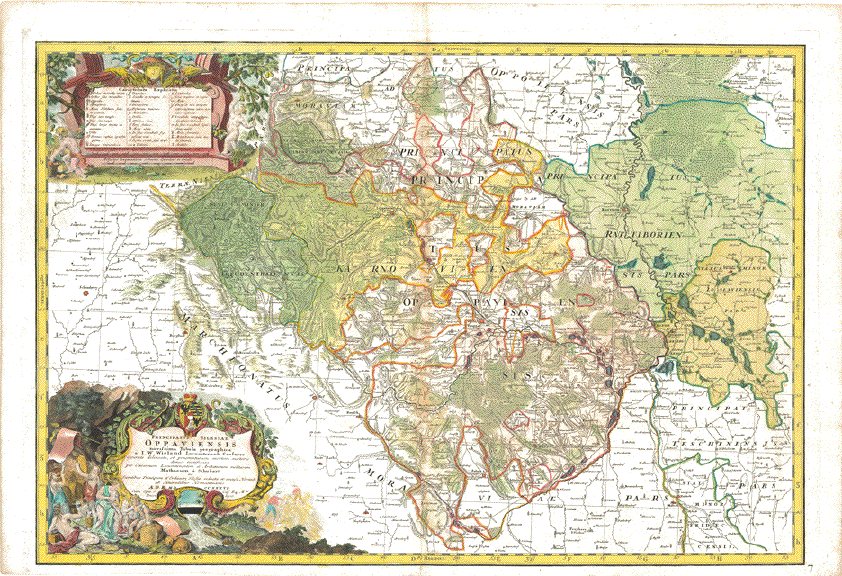
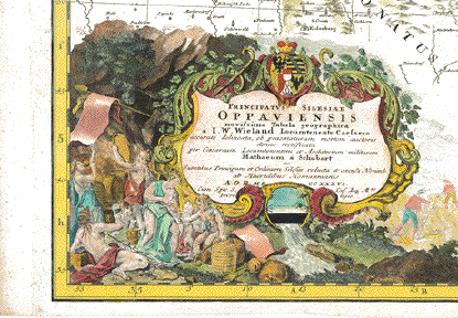
"Principatus Silesiae Oppauiensis novissima Tabula geographica a I.W.Wieland Locumtenente Caesareo accurate delineata, ob praematuram mortem auctorisdenuo rectificata per Caesareum Locumtenentem et Architectum militarem Matthaeum a Schubarth ac Sumptibus Principum et Ordinum Silesiae reducta et excusa Norimb. ab Haeredibus Homannianis A.O.R MDCCXXXVI�" Fuerstentum Oppau (heute grossenteils in Tschechien) mit Leobschütz (Polen), Jaegerndorf (Tschechien), Troppau (Tschechien). Handkolorierte Kupferstichkarte nach Zeichnung von Johann Wilhelm Wieland (? - 1736) und nach dessen Tod ueberarbeitet von Matthaeus Schubart (? - 1758). Aus dem "Atlas Silesiae". Herausgeber: Homann Erben, Nürnberg. Die Karte ist 1736 datiert und gedruckt. Der Atlas mit insgesamt 18 Kupferstichkarten ( zwei Übersichtskarten und 16 Fürstentuemer) im Gross-Folio-Format wurde insgesamt aber erst 1750 herausgegeben. Mit handkolorierter barocker Titelkartusche (mit Wappen des Fürstentums) und Legendenkartusche. Sehr detailliert. Kaum nennenswerte Alters- und Gebrauchsspuren. Principality of Oppau (Oppawa). Hand-colored copper etching after the drawing by Johann Wilhelm Wiegand (? - 1736) and, after his death, revised by Matthaeus Schubarth (ß - 1758). Published in the "Atlas Silesiae". Published by Homann Heirs in Nuremberg. The map is dated and printed in 1736, although the complete atlas with 18 grand-folio-size maps was published in its entirety in 1750. This very large map shows much detail. Even small villages are mentioned. Principality of Oppau, nowadays partially in the Czech Republich and partially in Poland. Very detailed and very decorative cartouches and hand coloring. Hardly any traces of age and use. 55 x 81,8 cm (ca. 21.7 x 32.2") Order Nr.DEUTSCHLAND248608SOLD |
|
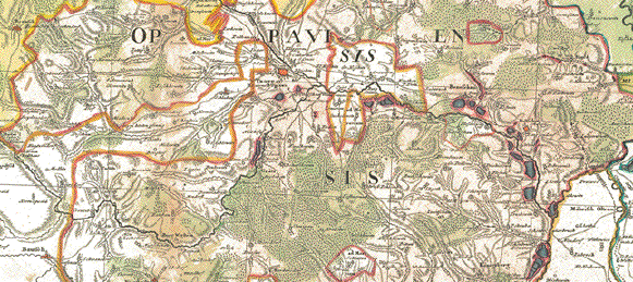
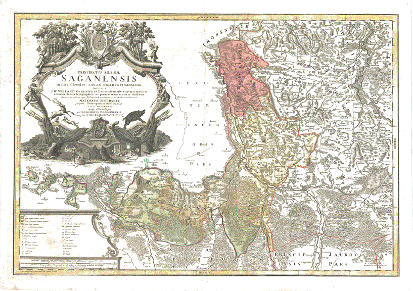
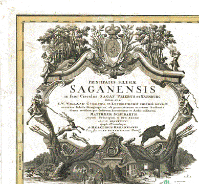
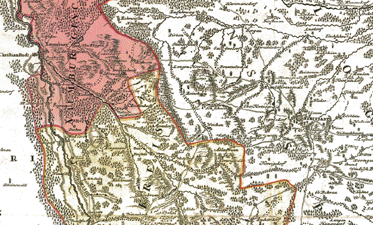
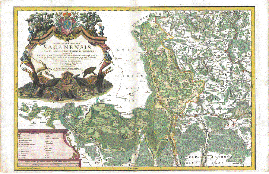
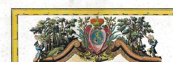
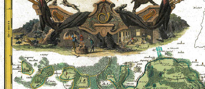
"Principatus Silesiae Saganensis in suos Circulos Sagan, Priebus et Naumburg divisi et a I.W. Wieland Geometra et Locumtenente emensi nova et accurata Tabula Geographica, ob praematuram mortem Authoris denuo rectificata per Caesareum Locumtenent et Archit. militarem Matthaeum Schubarth suptbus Principum et Ord. Silesiae A.C.R. MDCCXXXVI excusa Norimbergae ab Haeredibus Homannis�" Fuerstentum Sagan mit Sagan, Primus und Naumburg. Sehr grosse, detaillierte (selbst kleine Dörfer finden sich hier) handkolorierte Kupferstichkarte nach Zeichnung von Johann Wilhelm Wieland (? - 1736) und nach dessen Tod ueberarbeitet von Matthaeus Schubart (? - 1758). Aus dem "Atlas Silesiae". Herausgeber: Homann Erben, Nürnberg. Die Karte ist 1736 datiert und gedruckt. Der Atlas mit insgesamt 18 Kupferstichkarten ( zwei Übersichtskarten und 16 Fürstentuemer) im Gross-Folio-Format wurde insgesamt aber erst 1750 herausgegeben. Die sehr grosse und ornamentale Titelkartusche mit dem Wappen des Fuerstentums Sagan wie auch die dekorative Einfassung der Legendenkartusche sind nicht koloriert. Ausser dem Mittelfalz hat die Karte zwei weitere vertikale Faltungen und einen horizontalen Mittelfalz. Sie ist auf Leinen aufgezogen Hand-colored copper etching after the drawing by Johann Wilhelm Wiegand (? - 1736) and, after his death, revised by Matthaeus Schubarth (ß - 1758). Published in the "Atlas Silesiae". Published by Homann Heirs in Nuremberg. The map is dated and printed in 1736, although the complete atlas with 18 grand-folio-size maps was published in its entirety in 1750. This very large map shows much detail. Even small villages are mentioned. Very large and ornamental title cartouche with coat of arms of the Principality of Sagan (Zagan) is not colored. In addition to the normal centerfold there are two additional vertical folds and a horizontal centerfold. Map has been mounted on sheet of linen. 55 x 81 cm (ca. 21.7 x 31.9) $ 1100.00 Order Nr.DEUTSCHLAND248607 |
|
"Fürstentum Sagan". Dieselbe Karte wie vorige. Nur mit herausragend handkolorierter Titelkartusche und Legendenkartusche. Hervorragend handkoloriert. In sehr gutem Zustand. Untere Marge knapp. "Principality of Sagan". Same map as above. Except extraordinarily hand colord including the cartouches. Very good condition. Lower margin narrow $ 1400.00 Order Nr.DEUTSCHLAND248611 |
|
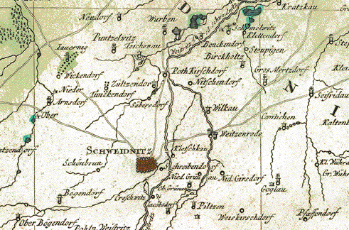
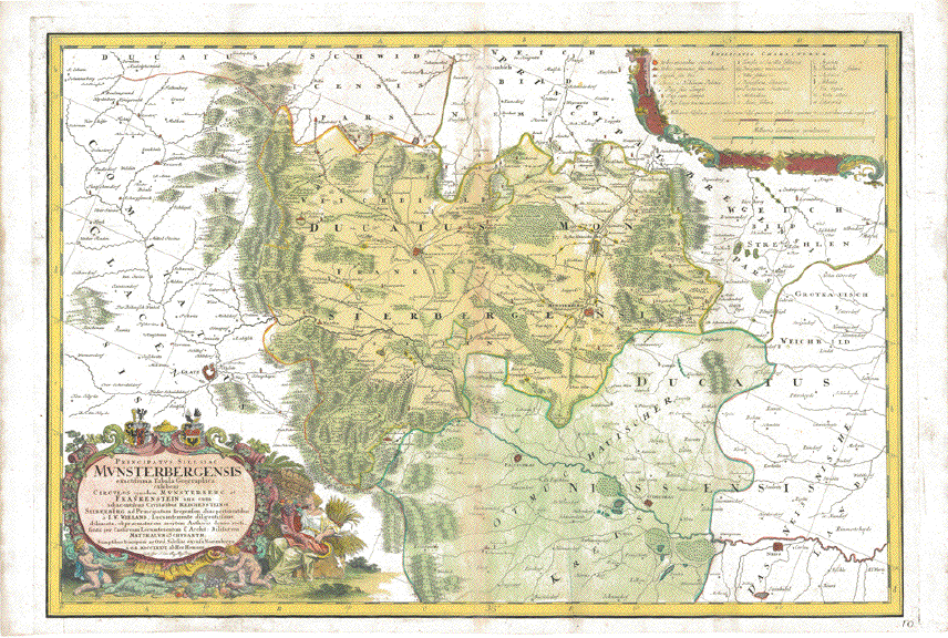
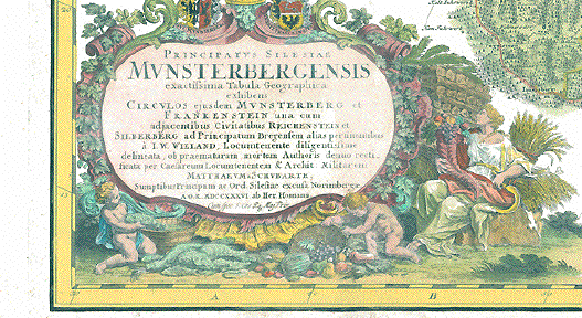
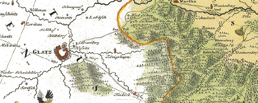
"Principatus Silesiae Munsterbergensis exactissima Tabula Geographica exhibens Circulos ejusdem Munsterberg et Frankenstein una cum adjacentibus Civitatibus Reichenstein et Silberberg ad Principatum Bregensem alias pertinentibus a I.W. Wieland, Locumtenente diligentissime delineata ob praematuram mortem Auhoris denuo rectificata per Caesareum Locumtenetem & Archit.: Militarem Matthaeum Schubarth Sumptibus Principum ac Ord. Silesiae excusa Norimbergae A.O.R. MDCCXXXVI. ab Her. Homann" Fuerstentum Muensterberg und Frankenstein. Sehr grosse, detaillierte (selbst kleine Dörfer finden sich hier) handkolorierte Kupferstichkarte nach Zeichnung von Johann Wilhelm Wieland (? - 1736) und nach dessen Tod ueberarbeitet von Matthaeus Schubart (? - 1758). Aus dem "Atlas Silesiae". Herausgeber: Homann Erben, Nürnberg. Die Karte ist 1736 datiert und gedruckt. Der Atlas mit insgesamt 18 Kupferstichkarten ( zwei Übersichtskarten und 16 Fürstentuemer) im Gross-Folio-Format wurde insgesamt aber erst 1750 herausgegeben. Sehr dekorative Titelkartusche mit Wappen von Haus Muensterberg und Haus Frankenstein. Rechts oben Legendenkartusche. Kaum nennenswerte Alters und Gebrauchsspuren. Verso im Mittelfalz einige minimale Reparaturen. Sehr angenehme Farben Hand-colored copper etching after the drawing by Johann Wilhelm Wiegand (? - 1736) and, after his death, revised by Matthaeus Schubarth (ß - 1758). Published in the "Atlas Silesiae". Published by Homann Heirs in Nuremberg. The map is dated and printed in 1736, although the complete atlas with 18 grand-folio-size maps was published in its entirety in 1750. This very large map shows much detail. Even small villages are mentioned. In the center of map are Frankenstein and Muensterberg. On the left is Glatz, at bottom are Patschkau, Otmuchau, Neisse. Large ornamental title cartouche with coats of arms of House Muensterberg and House Frankenstein. Upper right has ornamental explanatory cartouche. Hardly any traces of age and use. 55,5 x 81,3 cm (ca. 21.9 x 32") $ 1200.00 Order Nr.DEUTSCHLAND240605 |
|
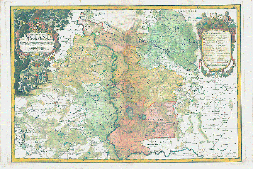
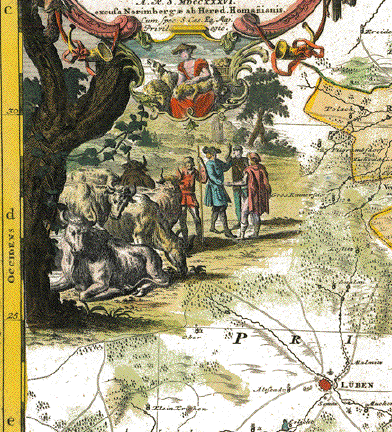
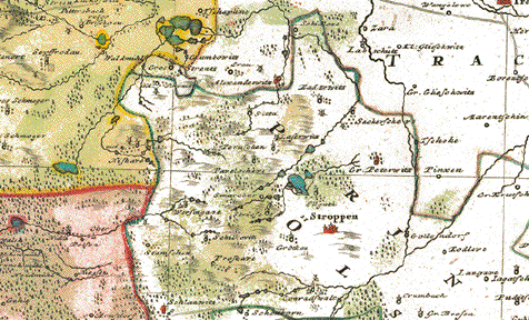
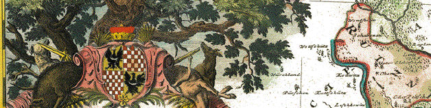
"Principatus Silesiae Wolani in suos Circulos Wohlau, Wintzig, Herrnstadt, Ruetzen, Steinau und Rauden divisi a I.W.Wieland Geometra et Locumtenente summa diligentia perlustrati et imensi Nova et accuratissima Tabula geographica ob praematuram mortem Authoris denuo rectificata per Caesar. Locumtenentem at Archit. militarem Matthaeum a Schubarth Sumptibus Pricipum et Ord. Silesiae A.R.S. MDCCXXXVI excusa Norimbergae ab Hered. Homannianis�" Fuerstenthum Wohlau mit fuerstlichem Wappen. Sehr detaillierte und dekorative handkolorierte Kupferstichkarte nach Zeichnung von Johann Wilhelm Wieland (? - 1736) und nach dessen Tod ueberarbeitet von Matthaeus Schubart (? - 1758). Aus dem "Atlas Silesiae". Herausgeber: Homann Erben, Nürnberg. Die Karte ist 1736 datiert und gedruckt. Der Atlas mit insgesamt 18 Kupferstichkarten ( zwei Übersichtskarten und 16 Fürstentuemer) im Gross-Folio-Format wurde insgesamt aber erst 1750 herausgegeben. Die Kartuschen wunderschön handkoloriert! Mittelfalz mit leichten Farbabweichungen. Untere Marge schon vor dem Druck professionell angesetzt. Plattenrand ist auf dem angesetzten Papier. Ansonsten sehr guter Zustand. Principality Wohlau (Wolow) with coat of arms. Hand-colored copper etching after the drawing by Johann Wilhelm Wiegand (? - 1736) and, after his death, revised by Matthaeus Schubarth (ß - 1758). Published in the "Atlas Silesiae". Published by Homann Heirs in Nuremberg. The map is dated and printed in 1736, although the complete atlas with 18 grand-folio-size maps was published in its entirety in 1750. This very large map shows much detail. Even small villages are mentioned. Very detailed and very decorative. Cartouches are very prettily hand-colored. Centerfold has some color disfiguration. Lower margin was added in Nuremberg before printing. Plate mark is on added paper. Otherwise no major traces of age and use. 55,6 x 81,2 cm (ca.21.9 x 32") $ 1100.00 Order Nr.DEUTSCHLAND248614 |
|
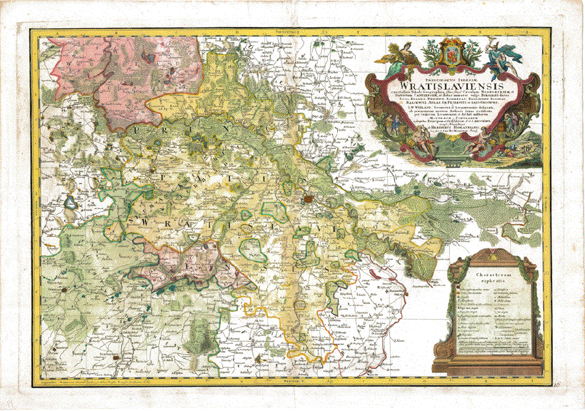
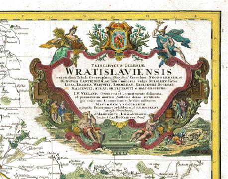
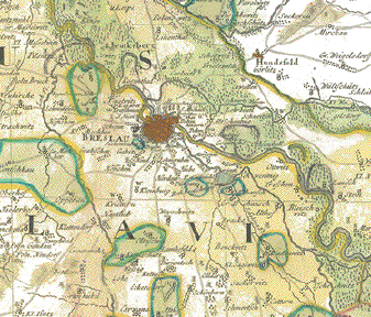
"Principatus Silesiae Wratislaviensis exactissima Tabula Geographica sistens simul Circulum Neoforensem et Districtum Cantiensem ac status minores vulgo Burglehn dictos Lissa, Kraicka, Weigwitz, Rommenau, Krolckwitz, Bogenau, Malckwitz, Auras, Gr. Peterwitz, et Halt-Grosburg, a I.W.Wieland Geometra et Locumtenente delineata ob praematuram mortem Authoris denuo rectificata per Caesareum Locumtenent et Archit. militarem Matthaeum a Schubarth ac sumptibus Principum et Ord. Silesiae A.O.R. MDCCXXXVI excusa Norimbergae ab Haeredibus Homannianis�" Fürstentum Breslau. Sehr detaillierte und dekorative handkolorierte Kupferstichkarte nach Zeichnung von Johann Wilhelm Wieland (? - 1736) und nach dessen Tod ueberarbeitet von Matthaeus Schubart (? - 1758). Aus dem "Atlas Silesiae". Herausgeber: Homann Erben, Nürnberg. Die Karte ist 1736 datiert und gedruckt. Der Atlas mit insgesamt 18 Kupferstichkarten ( zwei Übersichtskarten und 16 Fürstentuemer) im Gross-Folio-Format wurde insgesamt aber erst 1750 herausgegeben. Kaum Alters- und Gebrauchsspuren. Principality of Breslau (Wroclaw). Hand-colored copper etching after the drawing by Johann Wilhelm Wiegand (? - 1736) and, after his death, revised by Matthaeus Schubarth (ß - 1758). Published in the "Atlas Silesiae". Published by Homann Heirs in Nuremberg. The map is dated and printed in 1736, although the complete atlas with 18 grand-folio-size maps was published in its entirety in 1750. This very large map shows much detail. Even small villages are mentioned. Principality Glogau i Upper Silesia). Very detailed and very decorative cartouches and hand coloring. Hardly any traces of age and use. 55 x 79,8 cm (ca.21.7 x 31.4") $ 1700.00 Order Nr.DEUTSCHLAND248612 |
|
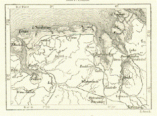
"Totus Marchionatus Lusatiae tam superioris quam inferioris Tabula Specialis...." Copper engraving by Johannes Baptist Homann in Nuremberg, ca 1715. Original hand coloring. In the center of this detailed Lausitz map is Hoyerswerda. In the upper left is Guterbock and Golsdorf. Above the decorative cartouche is Oschatz, Strehla, Dahlen and Riessa. At the bottom center of the map is Schoenbrunn, Schneeberg and Bautzen. In the lower right is Reichenberg. In the upper right is the confluence of the Bober and Oder rivers with the towns of Crossen and Bobersberg. Map has a few repairs in lower margin near centerfold. Two small repaired tears on left margin edge. Light browning of margin edges and a few light, scattered spots. 48 x 56.8 cm ( 18.8 x 22.3 ") $ 450.00 Order Nr. DEUTSCHLAND 1391 |
|
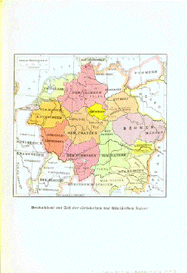
"Deutschland zur Zeit der saechsischen und fraenkischen Kaiser" Chromolithograph map showing
Germany at the time of the Saxish Map image: 11 x 12 cm ( 4.3 x 4.7") $ 30.00 Order Nr. DEUTSCHLAND253838 |
|
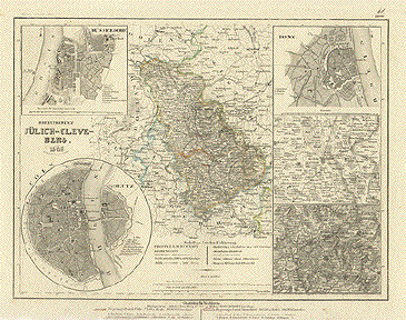
"Juelich-Cleve-Berg. 1849". Steel etching from "Neuster Zeitungs Atlas. Alter und Neuer Erdkunde" by J. Meyer, ca 1855. Original outline coloring. Right in ine center of this map is Duesseldorf. At the top of the map is Lochem and Ottenstein. The map reaches as far south as Maien and Bullingen. In the upper left is a detailed street plan of Duesseldorf with the Rhein on the left. In the lower left is a round inset of Cologne and Deutz showing the streets as they were in 1849. In the upper right is a detailed inset of Bonn with its streets and below is a detail of the environs of Krefeld and Linn. In the lower right corner is a detailed inset of Elberfeld and Barmen and their surroundings. Map has overall light toning and a few scattered spots in margins. 18.5 x 24.7 cm ( 7.2 x 9.7 ") $ 50.00 minus 30% Discount = $ 35.00 Order Nr. D1344 |
|
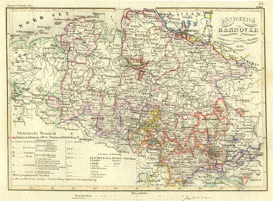
"Koenigreich Hannover 1852". Steel etching from "Neuster Zeitungs Atlas. Alter und Neuer Erdkunde" by J. Meyer, ca 1855. Original outline coloring. To the right os the title is Hamburg and on the left in light green is part of Holland. The map reaches as far south as Kassel and Sonderhausen. On the right is part of the course of the Elbe with Magdeburg. Map has overall light age toning and a few light spots in margins. 18.5 x 26.3 cm ( 7.2 x 10.3 ") Order Nr. D1346SOLD |
|
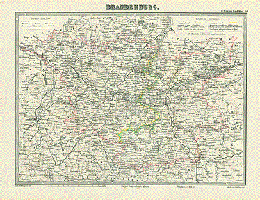
"Brandenburg" Lithograph by T. Brome and C. Baur. Published in Darmstadt ca 1860. Original outline coloring. In the center of the map is Berlin. In the upper right is Arnswalde and Schloppe. In the lower right if Gr. Glogau and Sprottchen. In the lower left is Querfurt and Mersburg. In the upper left is Rosendorf and Wittenberg. The railroad lines of the time are shown. The larger and smaller roads are on the map. Map has a vertical centerfold. A few minor spots. 26.5 x 38 cm ( 10.4 x 14.9 ") $ 85.00 minus 30% Discount = $ 59.50 Order Nr. D1400 |
|
"Provinz Brandenburg" Steel etching from "Neuster Zeitungs Atlas. Alter und Neuer Erdkunde" by J. Meyer, ca 1860. Original outline coloring. Berlin is in the center of this very detailed map. On the left side are detailed insets of Guben, Prenzlow and Frankfurt/Oder. At the bottom is a detailed inset of Neu Ruppin. In the lower right is an inset of Potsdam and the surrounding area. At the top are detailed insets of Zuellichau and Brandenburg. The date in the title cartouche has been erased. In the upper right is a page number written in ink. A few minor scattered spots. 18.2 x 24.5 cm ( 7.1 x 9.6 ") $ 50.00 minus 30% Discount = $ 35.00 Order Nr. D1401 |
|
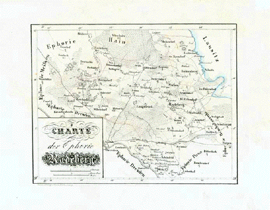
Radeberg. - "Charte der Euphorie Radeberg" Lithographie aus "Atlas des Königreichs Sachsen in 26 Karten" Von Friedrich Adolph Lüdicke und Carl Heinrich von Zobel Verlag: F.W. Godesche Herausgeber: Lithographisches Institut Pönicke & Sohn Leipzig, 1830 Guter Erhaltungszustand. Breite Margen. Rechte untere Margenecke mit Beschmutzung vom BlAEttern 19,8 x 25,5 cm $ 110.00 minus 30% Discount = $ $77.00 Order Nr. DEUTSCHLAND253123 |
|
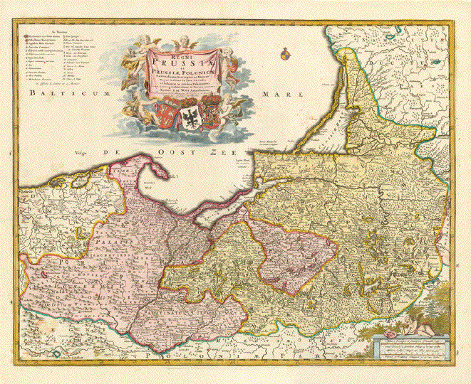
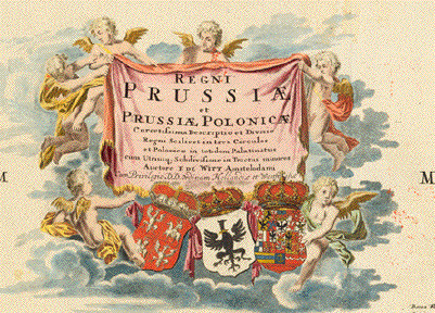
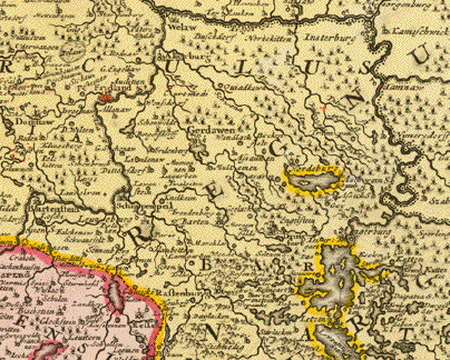
"Regni Prussiae et Prussiae
Polonicae Correctisima Descriptio et Divisio Copper engraving by Frederik De Wit - Covens and Mortier ca 1720-41. Shows part of East Prussia, Lithuania and Poland. Original hand coloring. Map has a strong imprint on heavy paper. Map has a vertical centerfold.
In the upper area under the word "Mare" are a few minor red
ink spots. 46 x 59 cm ( 17.8 x 23 ") Order Nr. DEUTSCHLAND249763 SOLD |
|
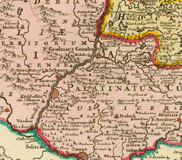
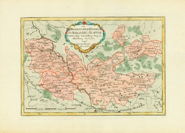
"Des Meissenschen Kreises Nördliche Ämter Finsterwalda, Senftenberg, Torgau, Mühlberg, Schatz und Grossenhayn" Altkolorierte Kupferradierung. Aus dem Atlas: "Schauplatz der fünf Thiele der Welt". Karte 358 Von Franz Johann Joseph von Reilly (1766-1820) Wien, 1791 Sehr sauber. Breite Margen. Nur
in oberer und unterer Marge erkennbare Quetschfalte. 21,7 x 32,2 cm $90.00 minus 30% Discount = $63.00 Order Nr. DEUTSCHLAND253095 |
|
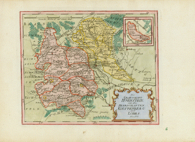
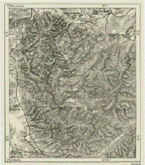
"Die Grafschaft Hohlsten mit den Herrschaften Klettenberg und Lohra" Altkolorierte Kupferradierung. Mit kleiner Insetkarte Benneckenstein Aus dem Atlas: "Schauplatz der fünf Thiele der Welt". Karte 375 Von Franz Johann Joseph von Reilly (1766-1820) Wien, 1791 Sehr sauber. Kleine unbedeutende Flecken in unterer Marge. Attraktives Altkolorit 23,7 x 29,2cm $90.00 minus 30% Discount = $63.00 Order Nr. DEUTSCHLAND253094 |
|
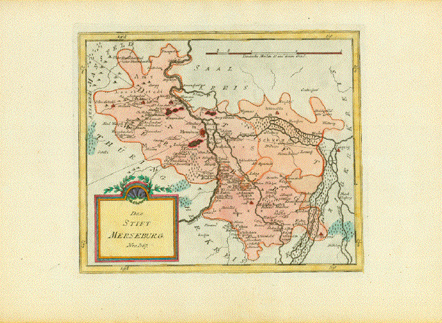
"Das Stift Merseburg" Altkolorierte Kupferradierung. Aus dem Atlas: "Schauplatz der fünf Thiele der Welt". Karte 381 Von Franz Johann Joseph von Reilly (1766-1820) Wien, 1791 Sauber. Breitrandig. Attraktives Altkolorit 22,5 x 26,5 cm $90.00 minus 30% Discount = $63.00 Order Nr. DEUTSCHLAND253096 |
|
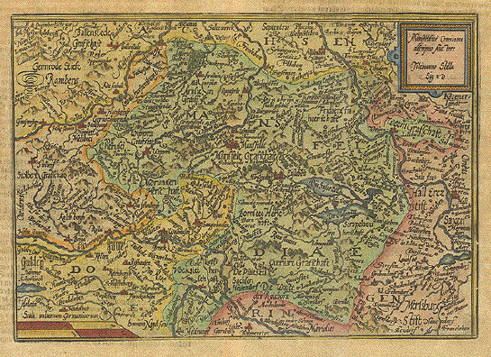
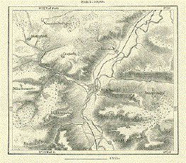
"Mansfeldiae Comitatus descritio". Copper etching by Tilmanno Stella for the atlas by Johann Bussemacher and Matthias Quad ( 1557-1613) in attractive recent coloring. Published ca 1595. Directly in the center of this map is Mansfeld. Halle is on the right side and in the lower right is Frankleben. On the left is Stolberg and in thr upper left corner is Stecklenberg. In the center at the bottom of the map is Wohlmirstedt. Verso: Text in German. Map has overall dark age toning. The margins are wide with some scattered spotting. some print from backside shows through the margins. General condition is Much Better than Good. 18.2 x 26.5 cm ( 7.1 x 10.4 ") $ 210.00 minus 30% Discount = $ 147.00 Order Nr DEUTSCHLAND 1282 |
|
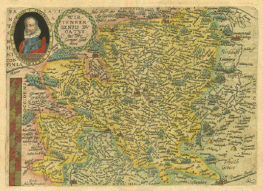
"Wirtenbergensis Ducatus". Copper etching by Georgio Gadnero for the atlas by Johann Bussemacher and Matthias Quad ( 1557-1613) in attractive hand coloring. Published ca 1595. Stuttgart is located in the center of this early map. Notice the decorative portait of Fridericus of Württenberg and Montisbelgardi. In the upper right of the map is Schwäbish Hall and in the lower right Ulm on the Danube. In the lower left is Freiburg in Breigau and to the right of the title is Maulbronn. Verso: Text in German. Map has overall age toning. Scattered spotting in margins. Some print from backside visible in upper margin. Fine creases in upper margin near centerfold and in lower margin. General condition is Much Better than Good. 22 x 31 cm ( 8.6 x 12.2 ") Order Nr. DEUTSCHLAND1288 SOLD |
|
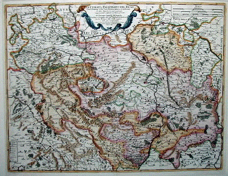
"Elettorato Palatinato Del Reno" Copper engraving by Giacomo Cantelli da Vignola, dated 1688. Published in Rome. Hand coloring. The course of the Rhine from Mulberg at the bottom to Bacharach, Kaub and Kamp to the left of the cartouche at the top is the central theme of this map. In the lower left is part of the Saar River. In the upper left is part of the Moselle River. In the upper right is Aschaffenburg on the Main River. Frankfurt is to the right of the cartouche. In the center is the Donnersberg with the towns of Polland and Iseberg. Map has a vertical centerfold. Some light scattered spotting in margins. Small repairs on centerfold in upper and lower margins. 42 x 54.5 cm (16.5 x 21.4 ") $ 520.00 minus 30% Discount = $ 364.00 Order Nr. D1382 |
|
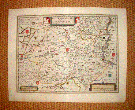
"Paderbornensis Episcopatus Descriptio Nova". Copper engraving by Ioanne Gigante Ludense for William Bleau, ca 1625. Original hand coloring. Right in the center of this atrractive map is Paderborn. Notice the various coats-of-arms at certain cities and towns. On the left center is Lippe. In the lower left is Ruden. In the upper left is part of the Weser River with Bodenwerder. Map has a vertical centerfold. Light scattered spotting in margins and minimal spotting in map image. 37.5 x 49 cm ( 14.7 x 19.3 ") $ 620.00 minus 30% Discount = $434.00 Order Nr. D 1383 |
|
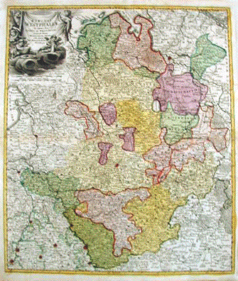
"Circuli Westphaliae in omnes suos Status et Provincias accurate divisi Nova et exacta Tabula". Copper engraving by J. B. Homan ca 1715. Hand coloring. Almost in the center of this map is Muenster. In the upper right corner is a bit of the Elbe River and Hamburg. A bit lower is the mouth of the Weser and part of the course of the Weser as far as Neustadt and Blumenau. In the lower right is part of Hesse with the Duchies of Nassau and Witgenstein. In the lower left is Maastricht and Luttich, Map has horizontal centerfold with original reinforcement. Light brownin along centerfold. A few light scattered spots in margins. Light creasing in left margin. 57 x 49 cm ( 22.4 x 19.3 ") $ 680.00 minus 30% Discount = $ 476.00 Order Nr. D1386 |
|
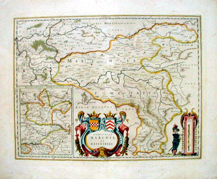
"Comitatus Marchia et Ravensburg" Copper engraving by William Bleau ca 1630. Original hand coloring. In the center of the map about the decorative cartouche is Hattington and Bochum. In the upper left is the confluence of the Weser and Lippe Rivers. In the lower left is an inset of the Duchy of Ravensberg. In the upper right of this inset is Minden and in the lower right is Paderborn. Map is printed on heavy paper with wide margins. Vertical centerfold. Browning on edges of margins. A few small, scattered spots in margins. 38 x 49.5 cm ( 14.9 x 19.4 ") $800.00 minus 30% Discount = $ 560.00 Order Nr. D1385 |
|
"Li Due Circoli dell' Alto e Baso Reno Secondo le Osservazioni dell' Accademia delle Scienze del Anno 1714". Copper etching from the Italian edition of an atlas by the "Royal Academy of Science" in Paris, 1714. The course of the Rhine river is the central theme of this map. It begins in the south with Breisach and continues north to Nijmegen. In the southeast above the cartouche is Ulm. In the northeast is Paderborn and Holzminden. Map has some light spotting. The left and upper margins have been widened. General condition is Almost Very Good. 16.9 x 13.5 cm ( 6.6 x 5.3 ") $ 85.00 Order Nr. D1238 |
|
|
"Elettorato e Palatinato Del Reno Con il Dominij della Casa Palatina annessi al Medesimo....." Copper etching by Giancomo Cantelli da Vignola. Dated 1688. Modern hand coloring. Right under the title cartouche is the confluence of the Main and the Rhine for orientation. In the northeast is Aschaffenburg and in the lower right is Besingheim. Part of Lorraine is in the lower left and Beilstein is in the upper left. The Rhine "enters" the map at the bottom a bit right of center. Map has some scattered light spotting in margins and a repaired tear in bottom margin. Condition is almost Very good. 42 x 54.5 cm ( 16.5 x 21.4 ") $ 720.00 Order Nr. D1258 |
More Maps of Germany (Page 8) - Mehr Landkarten von Deutschland (Seite 8)
© Rainer Rauhut