Sale! Discount!
30% Discount on All maps with a WORLDMAP number on this page!
We accept reasonable offers!
ALL PRICES ARE IN US $.
|
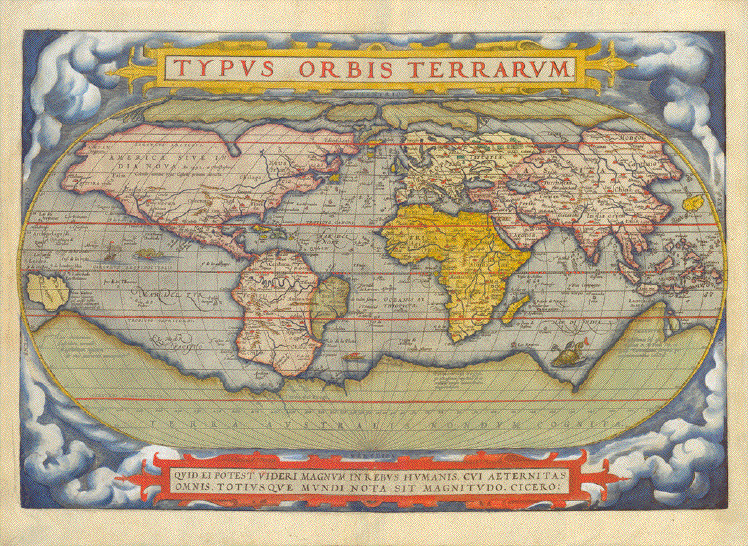
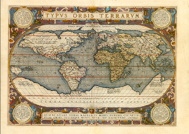
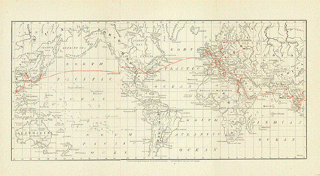
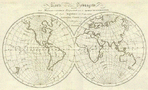
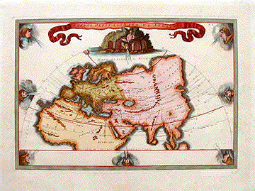
"Typus Orbis Terrarum" Hand-colored world map from the RARE first edition of the first world atlas ever printed "Theatrum Orbis Terrarum" by Abraham Ortelius (1527-1598) Hand-colored. Verso text: Latin The first edition of this first world atlas ever printed was published in Antwerp, 1570. There were two printings in 1570 and two more printings of the first edition in 1571 Published in Antwerp, 1570/71 Shirley 122; van den Broecke 1; Koeman/Meurer 1 World map: 33.2 x 49.8 cm (13.1 x 19.6"). Left and right margins professionally extended. Lower center fold enforced $ 6800.00 NO DISCOUNT ! Order Nr. WORLD2256 |
|
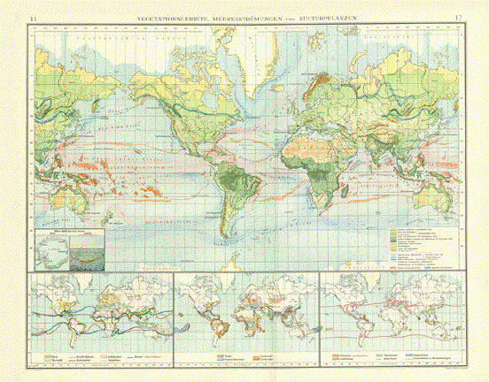
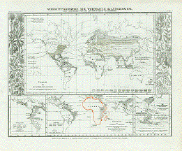
"Vegetationsgebiete, Meerestroemungen and Kulturpflanzen" A very interesting world map
dealing with the special regions for various kinds of
vegetation Published in 1899. Vertical centerfold. Map image: 38 x 48.5 cm 14.9 x 19 ") $ 95.00 minus 30% Discount = $ 66.50 Order Nr. WORLDMAP248847 |
|
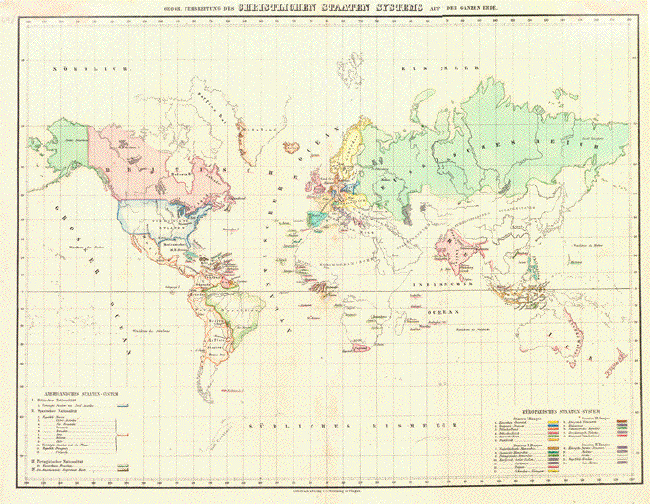
"Geogr. Verbreitung des Christlichen Staaten Systems auf der Ganzen Erde" Original hand-colored lithograph bei Flemming in Glogau, 1846. Map has vertical centerfold and a few minor signs of age.. 31.5 x 41 cm ( 12.4 x 16.1 ") $ 140.00 minus 30% Discount = $ 98.00 Order Nr. WORLD249157 |
|
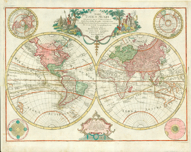
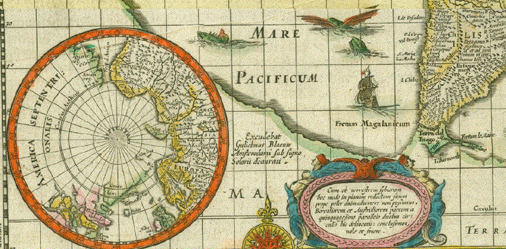
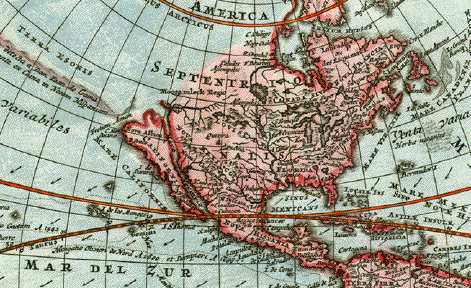
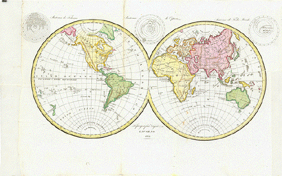
"Mappa Totius Mundi Adornata juxta Observationes Dnn Academiae Regalis Scientiarum et nonnulorum aliorum, secundum annotationes recentissimas. Per G. de Lisle Geographicum Parisiis" "Prostat nunc apud Ioannem Walch cum caeteris chartis geographicis Lotterianis in officina Ion. Martin Will. Aug. Vind." Hand-colored copper -etched World Map by Guillaume de L'Isle (1675-1726) and redesigned by Johannes Walch (1757-1816)and published by Johann Martin Will (1727-1806) in the publishing house of Conrad Tobias Lotter (1717-1777) Augsburg, 1787 Map showing many of the discovery voyages of earlier times. Australia and New Zealand quite well defined. Four hemispherical globes in the four corners of this appealing map. The pictorial title cartouche indication discoveries of far away lands and continents. On the right: The insignia of Freemasonry. Subtle hand coloring. Margins have some repairs. Centerfold has been supported in lower part and flattened out. There was some ink hand writing on reverse side, which is illegibly washed out. There is no text print verso. 45,5 x 62,5 cm (ca. 17.9 x 24.6") $ 1300.00 minus 30% Discount = $ 910.00 Order Nr. WORLDMAP252912 |
|
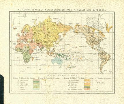
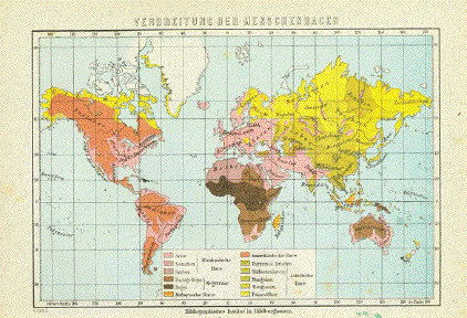
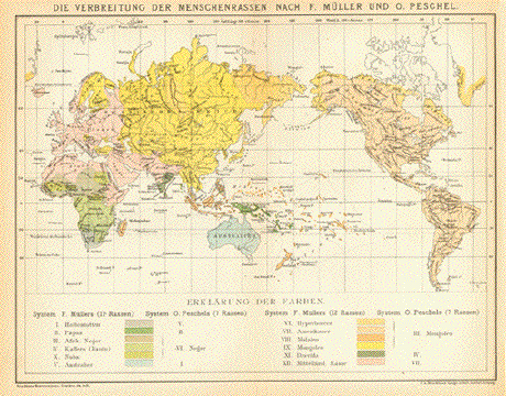
"Die Verbreitung der
Menschenrassen nach F. Mueller und O. Peschel" Published 1890. Map has folds to fit original
book size: A piece is missing in lower left corner Map image: 21.5 x 28 cm ( 8.4 x 11") $ 55.00 minus 30% Discount = $ 38.50 Order Nr. WORLD255915 |
|
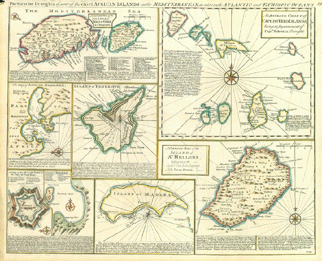
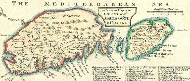
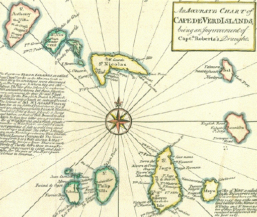
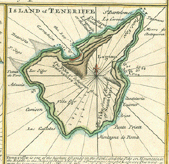
"Particular Draughts of some of the chief African Islands in the mediterranian, as also in the Atlantic and Ethiopic oceans". Copper engraving map by Emanuel Bowen(ca 1693-1767). From "A Complete System of Geography published in London ca 1750. Original hand coloring of the borders. 8 maps. "An accurate map of the islands of Malta Goze & Cuming" ; "An accurate chart of Cape de Verd Islands, being an improvement of Capt. Roberts's draught" ; "A correct map of the island of St. Hellena, belonging to the English East India Company" ; Island of Madera ; "A draught of Table Bay" ; "A plan of the Dutch fort at the Cape of Good Hope" ; "The Bay of Agoa de Saldanha" and "Island of Teneriffe." Signs of age and use in margins. Tiny piece of upper left margin corner is missing.Vertical centerfold. Map image: 35 x 43 cm (13.7 x 16.9") $ 390.00 minus 30% Discount = $ 273.00 Order Nr. ATLANTIC256874 |
|
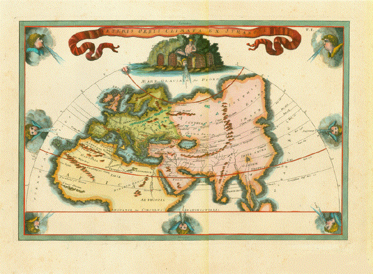
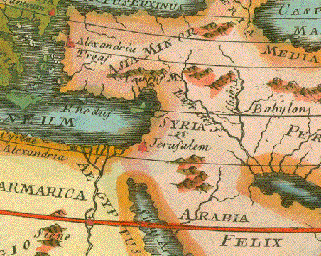
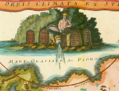
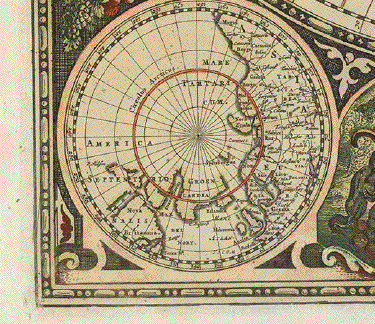
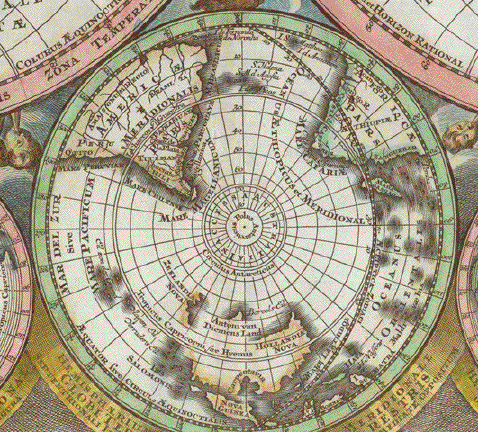
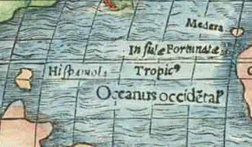
"Veteris Orbis Climata ex Strabone" Copper etching with finely executed hand coloring. Published in an atlas following the map published by Cellarius (Christoph Keller 1638-1707) in his �Ancient Geography", ca. 1730 The Strabo map was published in various versions, often smaller than this one, and sometimes without the angel heads blowing wind. This map published ca. 1750 Map of the �Old World with its climate zones." based on the ancient description in Strabo's Geography (Greek historian and geographer ca 60 BC - ca 30 AD) . The then known world comprised Europe, Asia and the northern parts of Africa. The western most geographical point are the Canary Islands named here �Fortunatae I." Decorative world map with 8 angel heads blowing winds across the world. There are 7 climate zones defined o this map, numbered I to VII (from south to north). Centerfold. Reverse side has no text. Margins show a bit of age toning. But map is in very good condition. Image: 30,2 x 44,6 cm (11.9 x 17.6") $ 480.00 (minus 30% discount = $ 336.00) Order Nr. WORLD2239 |
|
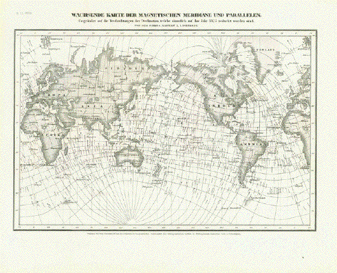
"Wachsende Karte der
Magnetischen Meridane und Parallen" Steel etching from "Neuster Zeitungs Atlas. Alter und Neuer Erdkunde" by J. Meyer, ca 1855. Image without title: 15.5 x 23.5 cm (6.1 x 9.2") $ 40.00 minus 30% Discount = $ 28.00 Order WORLD254853 |
|
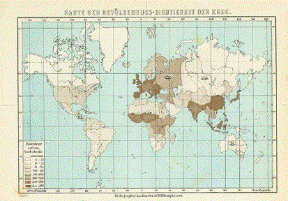
"Karte der Bevoelkerungs-Dichtkeit der Erde" Chromolithograph map showing the population densities. Published 1895.. Included is a separate page of very detailed statistics and facts about the population density. Map image: 10 x 15.5 cm ( 3.9 x 6.1") $ 30.00 minus 30% Discount = $ 21.00 Order Nr. WORLD254136 |
|
"Welt-Charte in Mercators Projektion 1849" Steel etching from "Neuster Zeitungs Atlas. Alter und Neuer Erdkunde" by J. Meyer, ca 1855. Original hand outline coloring. Attractive world map made after the Mercator Projection. Below the Southern Polar Circle is the sketched border Of Antarctica with a few of the early known places there.In the upper left is part of Greenland with Iceland and Spitzbergen. Very nice clean map. 19.5 x 24.8 cm ( 7.6 x 9.7 ") $ 55.00 minus 30% Discount = $ 38.50 Order Nr. WORLDMAP2263 |
|
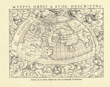
"Typus Orbis Terrarum" World Map Ortelius. Reference: Shirley 158 This is the third version of the world map by Abraham Ortelius. It is easily recognised by the four medaillons with classical citations (2 by Cicero and 2 by Seneca). Below the signature of Ortelius the map is dated: 1587, although this map was used for the first time in his atlas only in the year 1592. Type of print: Copper etching Color: Original hand coloring Author: Abraham Ortelius (1527-1598) Published in: "Theatrum Orbis Terrarum" Edition: French Text: Verso Fench language Ort: Antwerp Datum: 1598 Measurements: Ca. 35,5 x 48,5 cm ( 13.9 x 19 ") Condition: Centerfold and
margins are repaired. Centerfold has been flattened. $ 8000.00 minus 30% Discount = $5600.00 Order Nr. WORLDMAP236456 Reverse side:
|
|
"Orbis Terrae Compendiosa Descriptio ex ...Rumold Mercator... forma a Hieronymo Porro redacta" - Shirley 194 World Map - Rumold Mercator / Magini Type of print: Copper etching Artist: Girolamo Porro After: Gerard Mercator Published in: �Geografia cioe Descrittione Universale della Terra" Publisher: Gio. Battista & Giorgio Galignani Fratelli First published in: �Geographia" von Claudius Ptolemy Edition: Italian edition Editor: Giovanni Antonio Magini (1555-1617) Text: Italian. Complete on front and reverse side Published in: Venice Date: 1598 Measurements: Map size: Ca..16 x 24 cm Page size: Ca. 28,5 x 19 cm (ca. 11.2 x 7.5") Condition: Near perfect. Repaired tear in lower left margin. Very minor traces of age. $ 980.00 minus 30% Discount = $ 686.00 Order Nr. WORLD236457 |
|
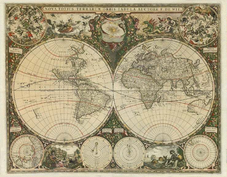
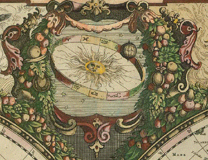
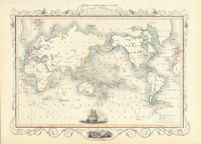
"Nova Totius Terrarum Orbis Tabula Auctore F. de Wit" Title Just above the bordure centralized: "t'Amsterdam by Frederick de Wit in de Calverstraet indue Witte Paskaert, 1660" Print: Copper etching Author: Frederick de Wit (1610-1698) Color: Original hand coloring Published: "De Zee-Atlas Ofte Water- Wereld�" By Hendrik Doncker Amsterdam, 1660 Very rare world map (Shirley World 421) was published in the Sea-Atlas by Doncker. Collectible specialty: California as an Island Two globes for the main part of the map show the "Old World" and the "New World" Decorative space use shows two Celestial globes upper left and right, North Pole and South Pole in lower left and right corner respectively. Two astronomical diagrams at bottom. Vignettes with figural portrayal of the four elements and hanging garlands of fruits and flowers complete the extraordinarily decorative map of the world. Below title: The sun with its rays inside a Zodiac ring. Shirley states: "De Wit's map is one of the most decorative standard-size maps of the time and it is much less commonly found than his three other atlas world maps�" The original hand coloring of the map-surrounding decor is elegant. The map itself has borderline hand color. Reverse side blank. Very good condition. Only minimal traces of age and use. Plate mark measuring: 44,3 x 56,6 cm (ca. 17.4 x 22.3") $ 14000.00 (minus 30% discount = $ 9800.00) Order Nr. WORLD MAP254638 |
|
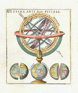
"Sfera artifiale" Type of print: Copper etching Color: Hand colored Author / Engraver: Anonymous Origin: Italian Time: Ca. 1700 Condition: Clean. Lower left has practically invisible repairs. Image: 14 x 12 cm (ca. 5.5 x 4.7") $ 130.00 Order Nr. ASTRONOMY238826 |
|
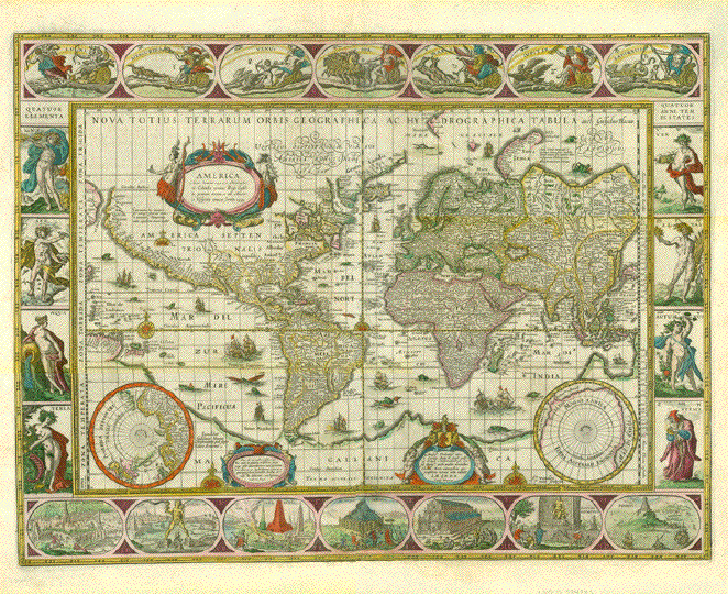
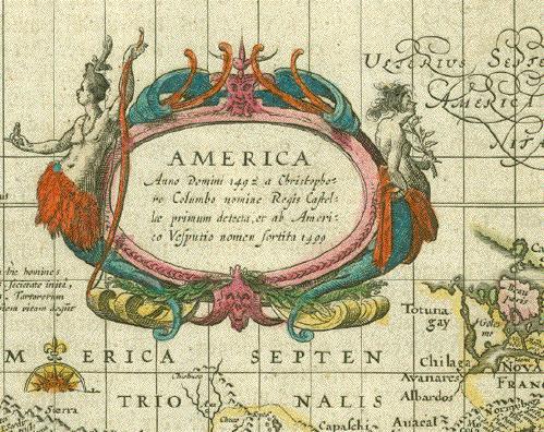
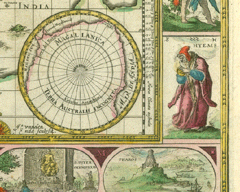
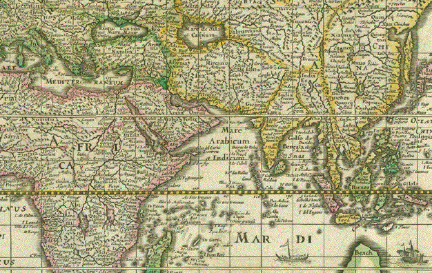
World map Willem (Guiljelmo) Blaeu "Nova Totius Terrarum Orbis Geographica ac Hydrographica Tabula auct. Guiljelmo Blaeuw." Copper etching with original hand coloring. Engraver: Jan van den Ende Cartographer: Willem (Guiljelmo) Blaeu (1571-1638) Reverse side text: German language State: 4, described as entry nr. 255 by Rodney Shirley in �Mapping of the World" Published: Amsterdam, ca. 1640 Map size: 41 x 54,4 cm ( ca. 16.1 x 21.4") Sheet size: 46,7 x 57,9 cm (ca. 18.4 x 23") This famous world map bears title over the top of map and has illustrious border decorations. Titles all in the Latin language. Along top are symbols of astronomy: Sun, Moon, Mercury, Venus, Mars Jupiter and Saturn. At bottom: Seven wonders of the world: Hanging Gardens of Babylon; the Colossus of the Island of Rhodes; the Pyramids in Egypt; the Mausoleum of Halicarnassus; the Temple of Diana; the Statue of Jupiter and the Lighthouse of Alexandria. On left side: the Four Elements: Fire, Air, Water and Earth. On right side: The Four Seasons: Spring, Summer, Autumn and Winter. - Inside map are three small baroque text cartouches, a map of the North Pole and one of the South Pole. And: Lovely sail ships, sea monsters etc. Map has been professionally restored. Bottom margin widened by ca. 1 cm. Vertical centerfold has been flattened. $ 13,000.00 (minus 30% = $ 9100.00 Order Nr. WORLDMAP 234939 |
|
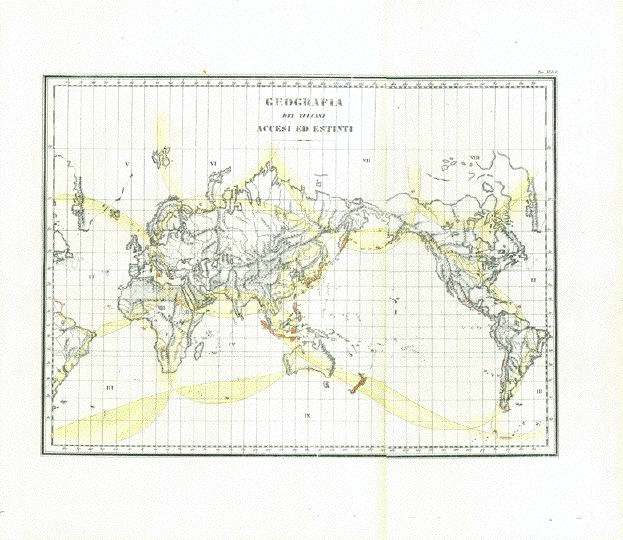
"Geografia dei vulcani accesi ed estinti" World geography of dead and active volcanos Lithograph with original hand coloring (only yellow marking the volcanic areas on earth) Published in �Atlante di Geografie Universale" (Atlas of Universal Geography) By Francesco Constantino Marmocchi (1805-1858) Published in Florence, Firenze, Florenz, 1840 With explanatory sheet in Italian language! Excellent condition. Map has two vertical folds to fit book size. 29 x 38,5 cm (ca. 11.4 x 15.2") $ 250.00 (Please look for discount at top of this page. Here 30% = $ 175.00) Order Nr.WORLD255523 |
|
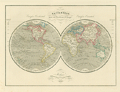
"Mappamondo preso sul Meridiano di Parigi" Steelengraving by Pietro Allodi after design by Filippo Naymiller. Milano, at Francesco Pagnoni, 1870. Very attractive world map in two hemespheres. Clean and well kept. Pleasant light overall age toning. Lower left corner in margin a bit hardly visibly wrinkly Otherwise excellent condition. 33 x 45 cm (13 x 17.7") $ 220.00 minus 30% Discount = $ 154.00 Order Nr. WORLDMAP2240 |
|
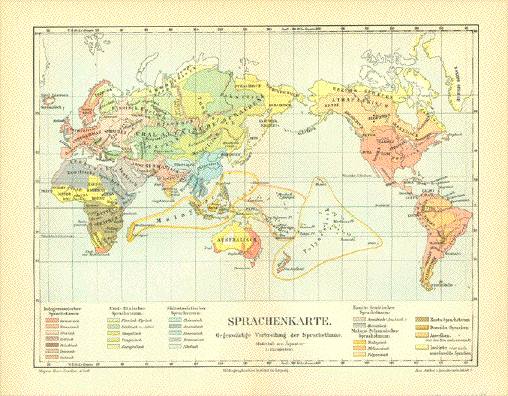
World map. - "Sprachenkarte. Gegenwaertige Verbreitung der Sprachstaemme" Linguistic world map. Chromo-lithograph Published in Leipzig, 1893 Excellent condition. Reverse
side blank. Horizontal centerfold. Overall measurments: 20 x 25,8 cm (ca. 7.8 x 10.1") $ 90.00 (Please look for discount at top of this page. Here 30% = $ 63.00). Order Nr. WORLDMAP255038 |
|
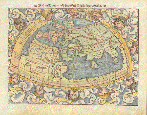
"Ptolemäisch general Tafel begreiffend die halbe kugel der weldt" Hand-colored woodcut Published in "Cosmographia" by Sebastian Muenster (1488-1552) German edition Basel, 1553 Muenster based this rendering of "half the globe of the earth" on Ptolemy's rendering. Ptolemy accounted for the knowledge of the geography of the earth of the second century A.D. Muenster, who had advanced knowledge, published the Ptolemean view to show the development. And indeed, at the time of printing his "Cosmographia" America was discovered and partially surveyed, and the closer to reality shapes of the continents of Europe, Asia and Africa had happened. So Muenster proudly published these "world maps" to show progress. Very nice condition. Margins with some thumb soiling in lower corners deriving from turning pages. Reverse side has title and translation of Latin explanatory words on one half of map. 25,5 x 34,3 cm (ca. 10 x 13.5") $ 1600.00 minus 30% Discount = $ 1120.00 Order Nr. WORLDMAP253287 |
|
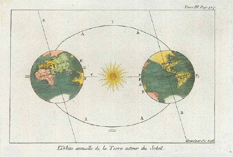
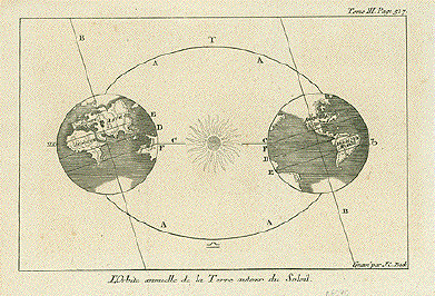
"L'Orbite annuelle de la Terre autour du Soleil" Hand-colored copper etching by Jakob Conrad Back Frankfurt on the Main, ca. 1760 This print from the French edition. About same time as the German edition. The sun hub of �our" galaxy. On the left �the Old World", on the right �the New World. In the center of map the sun. Clean. Very good condition. Two vertical folds to fit map into small book. 13,5 x 20,7 cm (ca. 5.3 x 8.1") WORLDMAP 254768 SOLD |
|
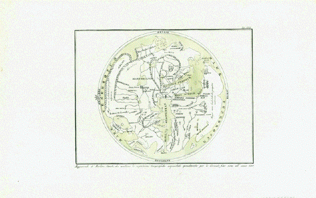
"Mappamondo di Martino Sanuto, che contiene le cognizioni Geografiche acqustate specialmente per le Crociate fino circa all' anno 1300" Jerusalem is marked with a cross as the center of the "world map". The map was designed by the cartographer Pietro Vesconte. His life dates are unknown. He was a Genovese (from Genua) and went to Venice where he was the first ever to publish portolan maps. Marino Sanudo the elder (1260-1338) was a Venetian geographer and influential politician, who is known to have promoted crusades to liberate Jerusalem and Palestine from Moslem rule. He used this very interesting map in his book �Liber Secretorum Fidelium Crucis", which was guide for crusaders. First published in 1306/07. The book had a second edition in 1321, in which this map was published. Details for this map: Lithograph with original hand coloring (just one color: green) Published in "Atlante di Geografie Universale" (Atlas of Universal Geography) By Francesco Constantino Marmocchi (1805-1858) Published in Florence, Firenze, Florenz, 1840 Excellent condition. Map image: 17,4 x 23,3 cm (ca. 6.9 x 9.2") $ 380.00 (Please look for discount at top of this page. Here 30% = $ 266.00) Order Nr. WORLD255476 |
|
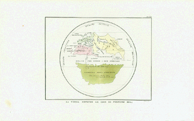
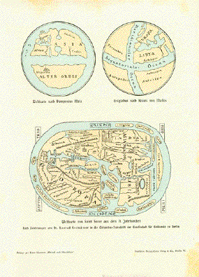
"La Terra secondo le Idee di Pomponio Mela" Lithograph with original hand coloring Published in �Atlante di Geografie Universale" (Atlas of Universal Geography) By Francesco Constantino Marmocchi (1805-1858) Published in Florence, Firenze, Florenz, 1840 Originally published by Pomponius Mela (life dates unknown) in his "De situ orbis" Published in 43 A.D. Shows some interesting firsts: Canary Islands (named Fortunate Islands), Cape Verde Islands (named Hesperien Islands). Thule, the mythical island in the North of Europe. Taprobana (Sri Lanka). Vague shape of Arabia. And vague shapes of Europe, North Africa and Asia. Excellent condition. Map Image:17.5 x 22.7 cm (ca. 6.9 x 8.9") $ 350.00 (Please look for discount at top of this page. Here 30% = $ 245.00) Order Nr. WORLD255475 |
|
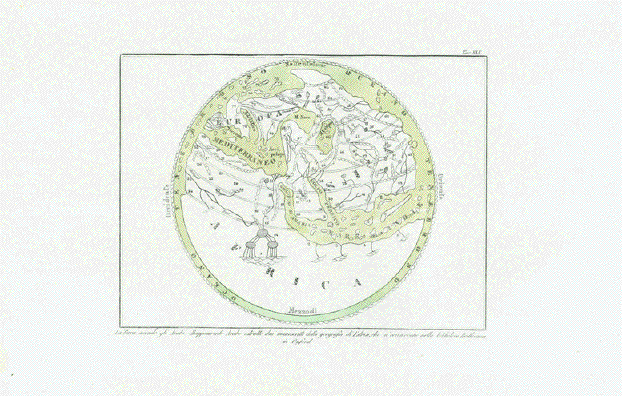
"La terra secondo gli Arabi, Mappa Mondo Arabe estratto dai manoscritte della geografia di Erisi, che si conscrvano nella biblioteca Bodleiana in Oxford" The earth drawn by the Arabs. With the key explanation. Lithograph with original hand coloring (just one color: green) Published in �Atlante di Geografie Universale" (Atlas of Universal Geography) By Francesco Constantino Marmocchi (1805-1858) Published in Florence, Firenze, Florenz, 1840 Excellent condition. Map Image: 17 x 23 cm (ca. 6.7 x 9") $ 420.00 (Please look for discount at top of this page. Here 30% = $ 294). Order Nr. WORLD255474 |
|
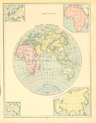
"Eastern Hemisphere" The interesting part of this
map is at the top center of the page is a tiny square Image: 27 x 20.5 cm ( 10.8 x 8") $ 50.00 minus 30% Discount = $ 35.00 Order Nr. WORLD255961 |
|
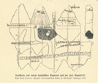
"Landkarte auf einem
aegyptischen Papyrus aus der Zeit Ramses II" Map is on a page of German text
about very early texts from the Greeks, Persians Published ca 1900 Image: 8 x 10.5 cm ( 3.1 x 4.1 ") Order Nr. MAPSWORLD249038SOLD |
|
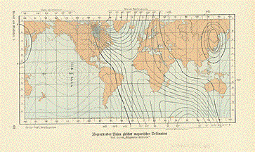
"Isogonen oder Linien magnetischer Deklination" Wood engraving map printed in color ca 1900. Reverse side is printed. 11 x 20 cm ( 4.3 x 7.8 ") $ 25.00 minus 30% Discount = $ 17,50 Order Nr. WORLD248634 |
|
Sale! Discount! 30% Discount on All maps with a WORLDMAP number on this page! We accept reasonable offers! Visit us at the following sites: https://lovelyantiqueprints.com twitter.com/philographikon2 |
|
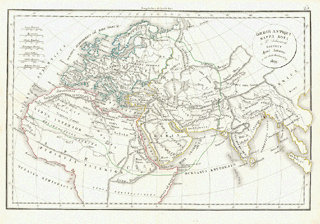
"Orbis Antiqui Mappa Nova a F. Delamarche Parisiis Apud Autorem in via dicti Jordinet Nr. 13" Very interesting map showing the known world. Many ancient names designate regions, settlements and topography. Copper engraving by F. Delamarche. Published in Paris, 1832. 28 x 42.5 cm ( 11 x 16.7 ") $ 125.00 minus 30% Discount = $ 87.50 Order Nr. WORLD242120 |
|
"Weltkarte von Saint Sever aus dem 11 Jahrhundert" Wood engravings made after the
drawings by Dr. Konrad Kretschmer of ancient maps. Some light spotting in margins. Page size: 26 x 19 cm ( 10.2 x 7.4 ") $ 55.00 minus 30% Discount = $ 38.50 Order Nr. WORLD252341 |
|
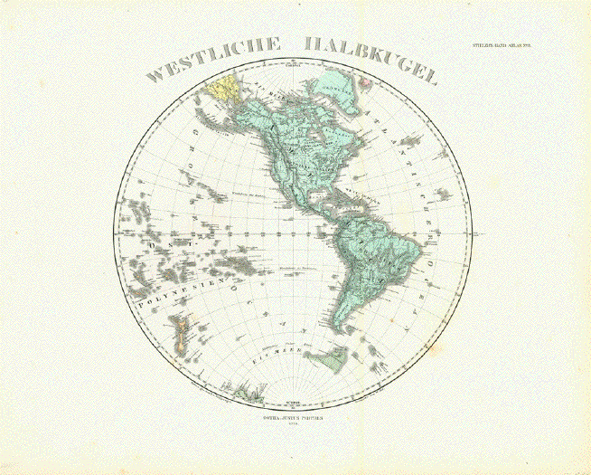
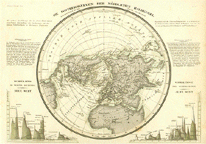
"Westliche Halbkugel" Steel engraving by Alt after F. von Stuelpnagel dated 1874. Published in Stieler's Hand Atlas. Very light browning and minor
signs of age and use on margin edges. Diameter of image: 27.5 cm (
10.8") $ 130.00 minus 30% Discount = $ 91.00 Order Nr. WORLD254473 |
|
"Erdansicht des Ptolemaeus" Wood engraving published 1881.
On the rverse side is German text about Image: 10.5 x 16.5 cm ( 4.1 x 6.4") $ 35.00 minus 30% Discount = $24,50. Order Nr. WORLD255818 |
|
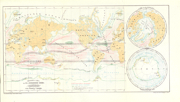
"Uebersichtskarte zu M. J. Schleidens Werk: "Das Meer" von Henry Lange" Very interesting
chromolithograph map of the world's oceans. Published
1869. The green lines show the
borders of drifting ice. Regions of Fucus natan are
shown. Map has two vertical folds to fit riginal book size. Very good condition. Map image: 20 x 38.5 cm ( 7.8 x 15.1") $ 100.00 minus 30% Discount = $ 70.00 Order Nr. WORLD255330 |
|
"Mappe - Monde. ou Carte Generale des toutes les Parties connues de la Surfaca du Globe selon la projection des Cartes réduites ou se trouvent les N (nouvelles) Decouvertes du Capit. Cook" World map. Originally hand-colored copper etching by Charles Francois Delamarche (1740-1811) Delamarche bought the rights to use the copper plates by Didier Robert de Vaugondy in 1786 Paris, ca. 1790. Legends upper left and upper
right indicate the color use for this map to show the
distribution on earn for ******* Weltkarte. Alt-handkolorierte Kupferstichkarte von Charles Francois Delamarche (1740-1811) Delamarche kaufte im Jahr 1786 die Kupferstichplatten von Didier Robert de Vaugondy. Paris, ca. 1790 Legenden oben links und oben
rechts geben das Farbspektrum, das auf dieser Karte die
Verteilung Saubere Weltkarte mit sehr
attraktivem Handkolorit. Mittelfalz hat kleine Reparaturen
und ist mit Papier des ******* Clean map of the world, with
very pleasant hand-coloring. Centerfold has some small
repairs and has been backed with 18th century paper. Along
centerfold: A bit darker paper color. Map image: 24,7 x 40 cm (ca. 9.7 x 15.7") $ 410.00 minus 30% Discount = $ 287,00 Order Nr. WORLD251978 |
|
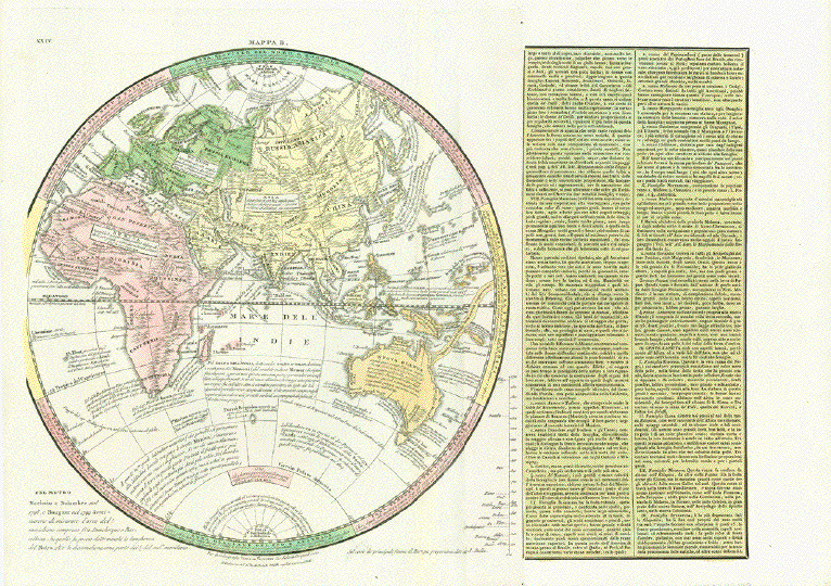
No Title. Hemispheric map. - "Mappa B" Copper etching by Giovanni Valerio Pasquali. Original hand color. Published in an atlas by A. Le Sage. Publisher: Tasso Venice, ca. 1830 No biographies of Pasquali or Le Sage available Language on map and commentary on right side: Italian Map includes 4 continents: Europe, Asia, Africa and Australia. Map focuses on discoveries including dates of voyages and names of discoverers. It gives measurements of square kilometers of each continent. A tabula with the lengths of Rivers in Europe is given. And, in the right side of map in two separate columns: The descriptions of native peoples in America, obviously a continuation of of the prior page of the atlas book. The description begins with Eskimos (Inuit), followed by descriptions of Mexicans, natives of Canada, natives of the Caribbean Sea, natives of Brazil, natives of th South Pacific, of Africa. "Mappa A" is missing. It shows most likely the Western Hemisphere For example: Of Iceland its
says: "Discovered in 860 by Norwegians". Australia is still
named �Nuova Ollanda" (New Holland). A rare map - and quite interesting Very good condition Map diameter: 33 cm (ca. 13") Full page: 38 x 53 cm (ca. 15 x 20") $ 700.00 (Please look for discount at top of this page. Here 30% = $ 490.00). Order Nr. WORLDMAP249149 |
|
No title. Copper engraving by B. Cole published 1755. Attractive hand coloring. Seldom!!! Two vertical folds to fit original book size. Good condition. Diameter of circle: 11 cm ( 4.3
") $ 220.00 minus 30% Discount = $ 154.00 Order Nr. WORLDMAP245245 |
|
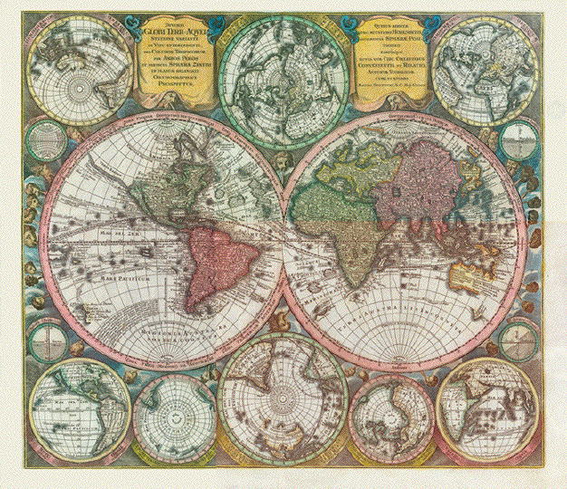
Left cartouche: "Diversi Globi Terr-Aquei Statione Variante Et Visu Intercedente Per Coluros Tropicorum, Per Ambos Polos Et Partciul Sphaerae Zenith In Planum Delineati Orthogranici Prospectus" Right cartouche: ""Quibus additive pro Mutatione Horizontis Differentes Spaeeae Positiones earumque Mutua cum Circ. Coelestibus Cenvenientia et Relatio Augustae Vindelicor. Cura et Studio Matth. Seutteri. S.C. Maj. Georgr." Originally hand-colored copper etching by Matthaeus Seutter (?-1757) Augsburg, Germany, 1744 Very decorative world map with two hemispheres. These are surrounded by several globes. Clockwise from upper left: Southern hemisphere (South Pole) Australia showing- Northern hemisphere (Perpendicular from North Pole) - Northern hemisphere (oblique from North Pole) - The equator straight on - the equator oblique view - The Old World - Northern hemisphere perpendicular from North Pole - South Pole perpendicular view with a vague view of Australia - Another view from South Pole - The New World with California as an island - Vertical horizon - The earth graticule. Map has very beautiful original hand coloring, is clean and has ample margins on all sides. Centerfold has been smoothed and reinforced top 3 inches. Verso blanco. 49.5 x 57.5 cm (ca. 19.5 x 22.6") $ 3600.00 minus 30% Discount = $ 2520.00 Order Nr. WORLDMAP251874 |
|
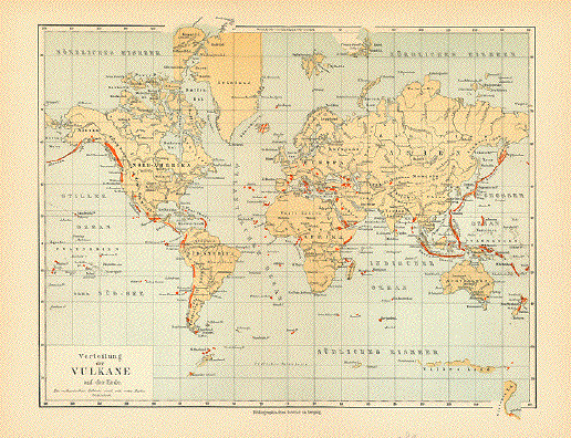
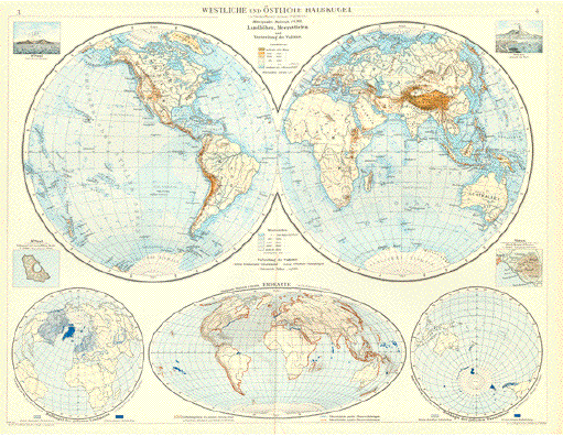
"Westliche ind Oestliche Halbkugel in flächentreuem Azimutal-Entwurf. - Landhoehen und Meerestiefen und Verbreitung der Vulkane" Western and eastern hemisphere with accurate azimuthal angle. Highest points on earth and ocean depths. - and locations of vulcanos on earth On the left St. Paul vulcano view and aerial view. On the right Vesuvius and aerial view. Ecliptic world map showing aeries of earth quakes. In the left lower corner: Polar view of the earth (north). Io the right lower corner: Polar view of the earth (south) Clean. Paper thin along vertical centerfold. Overall size: 40x 52cm (ca. 15.7 x 20.5") $ 180.00 (Please look for discount at top of this page. Here 40% = $ 108.00) Order Nr. VOLCANO254051 |
|
Map prepared for "Around the World with General Grant" showing his travel route. Published 1880. Verticals folds to fit original book size. Minor creasin in upper right magin corner. 19 x 40 cm ( 7.4 x 15.7 ") $ 70.00 minus 30% Discount = $ 49.00 Order Nr. WORLDMAP249731 |
|
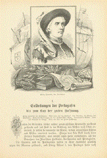
"Prinz Heinrich, der Seefahrer" *****
"Prinz Heinrich am Portal des Klosters von Belem" ***** Article: "Entdeckungen der Portuguesen bis zu Kap der guten Hoffnung" 7-Page article about the
discoveries and expeditions of the Portuguese with two Page size: 20.5 x 14 cm (8x 5.5") Price for the 7 pages: $ 55.00 minus 30% Discount = $ 38.50 Order Nr. WORLD255938 |
|
"Welt-Charte in Mercators Projektion 1830". Steel engraving from "Geographischen Instituts in Hildburghausen", ca 1840. Modern hand coloring. Interesting map of a Mercator projection of the world at that time. Map has wide margins. Minor spotting on map image mostly visible from backside. 17 x 22.7 cm ( 6.7 x 8.9 ") $ 55.00 minus 30% Discount = $ 38.50 Order Nr. WORLD MAP 2237 |
|
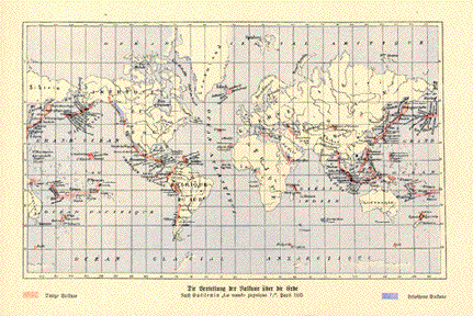
"Weltverkehrs-Karte" World traffic map. Published in Meyers Kleiner Handatlas. Leipzig, 1892. Insets: North Sea. Mediterranean Sea. German, British, French, Dutch, Spanish, Italian, Portugeese, danish colonies are marked by the use of diverse colors. Fold-out world map focussing on sea and railroad travel lines. Sea- and ocean travel Light general age toning. Fold-out map has two vertical folds. One of them has small, insignificant repaired tear. Print very fine. 21 x 40 cm (8.3 x 15.7") $ 35.00 minus 30% Discount = $ 24.50 Order Nr. WORLDMAP235665 |
|
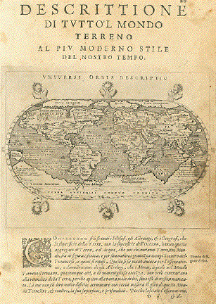
"Descrittione di tutto'l Mondo Terreno al piv moderno Stile del nostro Tempo" (Shirley 194) Worldmap by Rumoldo Mercator. Copper etching published in �Geografia cioe Descrittione Universale della Terra" Printed byGio. Battista & Giorgio Galignani Fratelli. Venice, 1598 First edition in Italian language. Edited by Giovanni Antonio Magini (1555-1617) Shirley writes: Rumold Mercator's double-hemispherical world map has been reengraved in reduced format by Girolamo Porro. It is to the artist's credit that so much detail has been represendted with such fineness and clarity.... This small Mercator-Porro map is a worthwile collector's item, particularly as the larger Mercator world map is becoming increasingly scarse. Genral age toning. Some traces of age and use, especially on the right side of map and at bottom. There is a repaired tear in lower margin. Lower right margin corner is soiled from turn-page finger prints. Sheet size: 28 x 19 cm (11 x 7.5") Map size: 13 x 17.5 cm (5.1 x 6.9") Order Nr. WORLDMAP235666 SOLD |
|
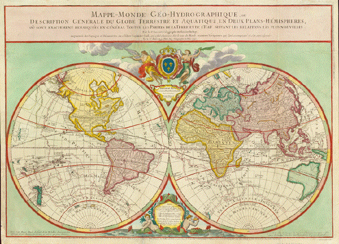
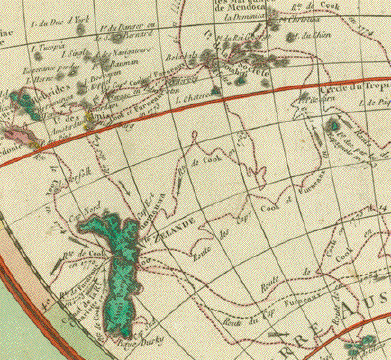
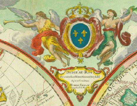
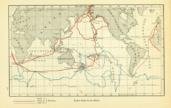
"Mappe Monde
Geo-Hydrographique ou descrition Generale du Globe Terrestre
et Aquatique en Deux Plans Copper engraving by Brion de Tour after Jaillot dated 1790. Very fine hand coloring. Published by Defnos, Rue St. Jacques in Paris. Rare map. Map shows the expedition routes of Captain Cook on his three voyages between 1769 and 1779. This map was once folded. The
folds have been flattened and are hardly visible. Map image 45.5 x 64.5 cm ( 17.9 x 25.3 " $ 1800.00 minus 30% Discount = $ 1260.00 Order Nr. MAPWORLD251406 |
|
"Erdansicht des Stratosthenes" Wood engraving published 1881.
On the rverse side is German text about Image: 10.5 x 16.5 cm ( 4.1 x 6.4") $ 35.00 minus 30% Discount = $24,50. Order Nr. WORLD255817 |
|
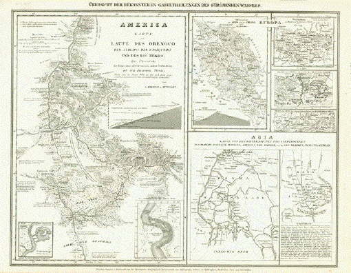
"Uebersicht der Bekannteren
Gabeltheilungen des Stroemenden Wassers" On the left side is the Orinoco
and Rio Negro. On the right side in Euope are Arno,
Chianna, Steel etching from "Neuster Zeitungs Atlas. Alter und Neuer Erdkunde" by J. Meyer, ca 1855. Image size without title: 22 x 28 cm ( 8.6 x 11") $ 45.00 minus 30% Discount = $ 31.50 Order Nr. WORLD254851 |
|
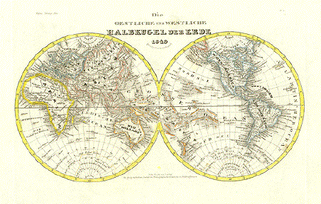
"Die Oestliche und Westliche Halbkigel Der Erde 1849". Steel etching from "Neuster Zeitungs Atlas. Alter und Neuer Erdkunde" by J. Meyer, ca 1855. Fine world map showing many geographical details. Map is very clean. Small repaired tear on lower margin edge. Page size: 25.5 x 30.5 cm ( 10 x 12 ") $ 60.00 minus 30% Discount = $ 42.00 Order Nr. WORLD MAP 2232 |
|
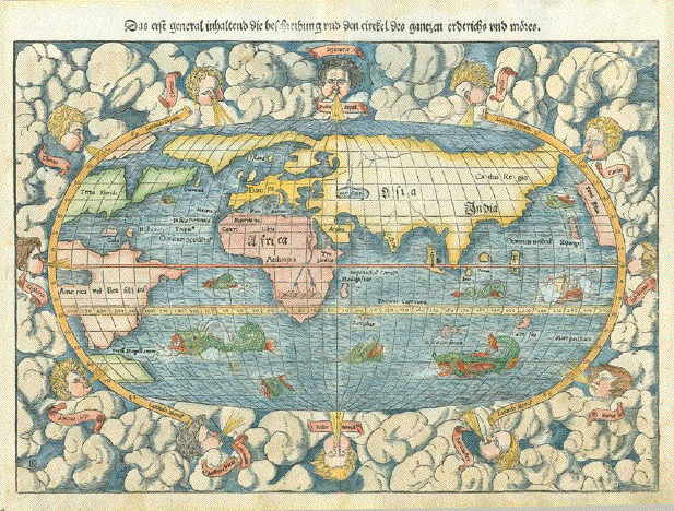
Reverse side:
"Das erst Inhalten die Beschreibung und den circkel des gantzen Erdreichs und moeres" Map of the world. Hand-colored woodcut Published by Sebastian Muenster (1488-1552) Printer by Heinrich Petri German edition Basel, 1553 Initials of artist: DK (David Kandel). He was Muenster's son-in-law. Very good condition. Very light traces of age and use. Reverse side (on one half) title and explanations of Latin words used in map. 26,5 x 38 cm (ca. 10.4 x 15") Order Nr. WORLDMAP253270SOLD |
|
"Weltkarte aus der Zeit Karl's V, von Frankreich (1364-1380)" Very early map that shows Egypt
and Babylonia and the right side. In the lower left is
Europe Page size: 20 x 13,5 cm ( 7.8 x 5.3") Order Nr. WORLDMAP253043SOLD |
|
"Juan de la Cosa a la fizonel puexto...." Wood engraving published 1881
on a page of text about the exploration of Light, natural age toning. Page size: 18 x 12 cm ( 7 x 4.7") $ 25.00 minus 30% Discount = $ 17.50 Order Nr. WORLDMAP256923 |
|
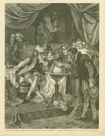
"Kolumbus sucht das
Koeningspaar Ferdinand und Isabella von Spanien im Lager ( In Sante Fe near Granada,
Columbus tries to get the support of Ferdinand Wood engraving after Franz
Kollartz. Published 1879. Image: 32 x 23.5 cm ( 12.5 x 9.6") $ 80.00 Order Nr. ESPAÑA254756 |
|
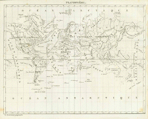
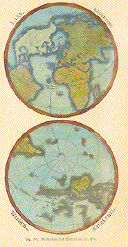
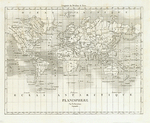
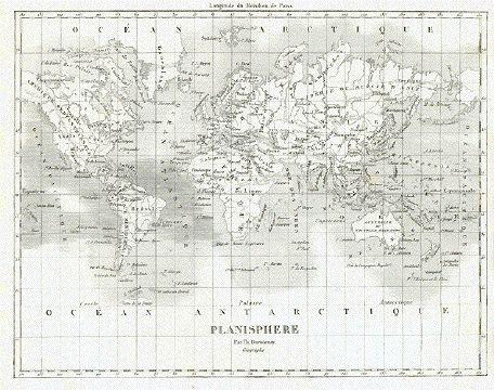
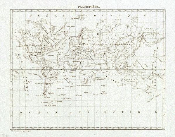
"Planisphere" Lithographed world map by Th.
Duvoteney published 1840. Image: 18 x 23 cm ( 7 x 9") $ 55.00 minus 30% Discount = $ 38.50 Order Nr. WORLD254161 |
|
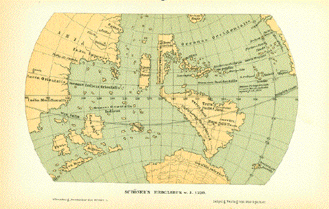
"Schoeners Erdglobus b. J. 1520" Very interesting historical map made after the globe by Johannes Schoener (1477-1547). This globe is one of the
world's oldest and is in the Historischen Museum von
Frankfurt am Main. This map was published in 1881. Light natural age toning. Image: 10.5 x 17cm ( 4.1 x 6.6") $ 35.00 minus 30% Discount = $ 24.50 Order Nr. WORLDMAP256919 |
|
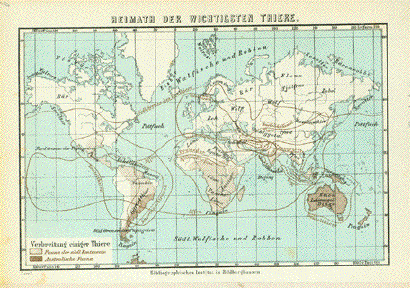
"Heimat der Wichtigsten Thiere" Map shows the original locations of some of the most important animals. Published ca 1890. Extra page ( in German ) of information about the various animal habitats. 10 x 15.5 cm ( 3.9 x 6.1 ") $ 35.00 minus 30% Discount = $ 38.50 Order Nr. WORLDMAP250664 |
|
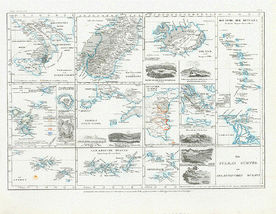
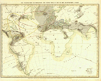
"Die Vulkan Gürtel des Atlantischen Oceans". Steel etching from "Neuster Zeitungs Atlas. Alter und Neuer Erdkunde" by J. Meyer, ca 1855. Original hand coloring. Map shows the various volcanic systems near the Atlantic Ocean and Mediterranean Sea. The upper left is the area of Calabria and Sicily of Italy. The center is a larger detail of the earthquake area of Calabria and Sicily. The next diagram is Iceland with two diagrams showing the craters of a large geyser and of the volcano Eyafiael on the Island Eyar. The long map on the right side is of the Antilles and northern Venezuela. The middle left map shows the Lipari Islands with a special detailed diagram of the volcano Ferdinandea (Graham's Island). The next map is of Naples and surrounding area with speical deatails of Vesuvius. The next map with orange outlining shows the east coast of Sicily with a special diagram of Etna. The next is the Greek islands with a special detail of Santorin. In the lower left corner are the Azores and in the middle the Canary Islands. The comes a map of the Cape Verde Islands. The dark diagrams to the left of the title show deep earth cracks in Calabrian near Rosarno. Map hassmall spot in lower left image. Otherwise good condition. 19.5 x 28 cm ( 7.6 x 11 ") $ 100.00 Order Nr. VOLCANO240741 |
|
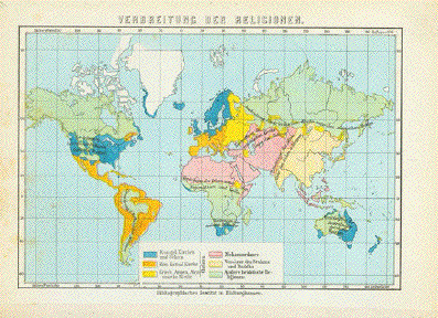
"Verbreitung der Religionen" Chromolithograph map showing the regions of the major world religions Published 1895.. Included is a separate page of very detailed statistics and facts about the world's religions. Map image: 10 x 15.5 cm ( 3.9 x 6.1") $ 30.00 minus 30% Discount = $ 21.00 Order Nr. WORLD254134 |
|
"Planiglobii Terrestris Mappa Universalis Utrumqs Hemisphaerium Orient et Occidentale�...,,MDCCXXXVI" Title also in the French language in the right cartouche. Type of print: Copper etching Color: Very fine hand coloring Publisher: Homann Heirs Where / when published: Nuremberg, Germany, dated 1746 Map was compiled by J.M. Haas, Professor of Mathematics at Wittenberg. Condition: Very pleasant hand coloring. Minor repairs on centerfold. Wide margins show some traces of age and use. A few light scattered creases. In general: Almost very good. Attractive double hemisphere map of the world, Earth seen from north pole and from south pole inhemispheric maps, plus two celestial models. Includes incomplete Australia and New Zealand, NW Coast of America based upon the early Russian explorations (Alaska titled:Russian America). 44.7 x 52.4 cm ( ca. 17.6 x 20.6" ) $ 1950.00 minus 30% Discount = $ 1365.00 Order Nr. WORLDMAP 2257 |
|
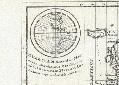
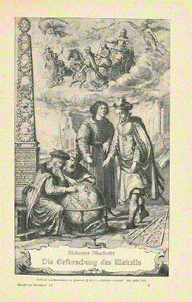
Ortelius World Maps FIRST EDITION The world, America, Asia, Africa, Europe Set of 5 maps. Copper etchings from the Atlas "Theatrum Orbis Terrarum" by Abraham Ortelius. Antwerp, 1570. Verso text: Latin. Excellent hand coloring in the typical Renaissance style. This homogenous set derives from an atlas printed in the year 1570. The atlas, of which this set was a part, was the FIRST EDITION of the famous first atlas ever printed. Order Nr. WORLD MAP 2256 Please visit this webpage to view the maps: |
|
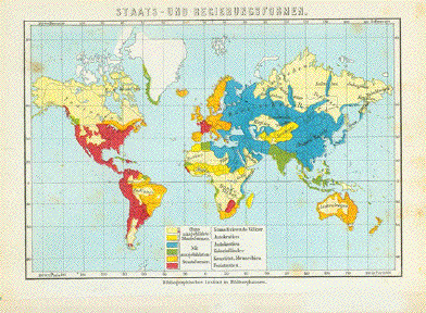
"Staats- Und Regierungsformen" Chromolithograph map showing thethe forms of government around the world. Published 1895.. Included is a separate page of very detailed statistics and facts about the world governments. Map image: 10.5 x 15.5 cm ( 34.1 x 6.1") $ 30.00 minus 30% Discount = $ 21.00 Order Nr. WORLD254133 |
|
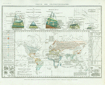
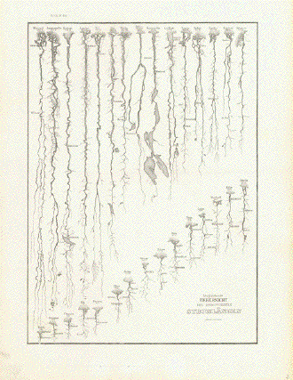
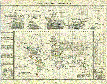
Umrisse der Pflanzengeographie. Steel etching from "Neuster Zeitungs Atlas. Alter und Neuer Erdkunde" by J. Meyer, ca 1855. Original hand outline coloring. This very interesting map shoes the various growing zones around the world. At the top are interesting diagrams of known mountains showing the elevations at which various plants grow. Map is clean and in good condition. 20.3 x 28.5 cm ( 7.9 x 11.2 ") $ 70.00 minus 30% Discount = $ 49.00 Order Nr. WORLD2247 |
|
"The World on Mercators Projection shewing the voyages of Capatin Cook round the world" Steel engraving with very fine original borderline hand coloring. Published in "The New Atlas" by John Tallis and J. Rapkin London and New York City, 1849-1853. The very decorative world map shows the three voyages by Captain James Cook. They are distinguished by different dotted lines, arrows show direction of sailing and dates of sailing are marked. An ornamental map border, a sailing ship and South Sea weaponry are decorative assets. Very light pleasant age toning. Map is almost flawless. Nice addition to anyone's World Map or James Cook collection 24 x 31 cm (ca. 9.4 x 12.2") $ 220.00 minus 30% Discount = $ 154.00 Order Nr. WORLDMAP241752 |
|
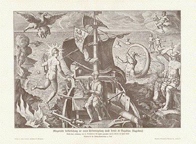
"Allegorische Verherrlichung der ersten Weltumseglung durch Fernao de Magalhaes (Magellans)" Wood engraving made after Stradanus Published 1900. Vertical centerfold. 22 x 31 cm ( 8.6 x 12.2 ") $ 40.00 minus 30% Discount = $ 28.00 Order Nr. WORLDMAP246898 |
|
"Orbis 'T'abula quatenus a Veteribus cogniti...." Copper engraving by Hermann
Moll, 1732. In the upper left is the american hemisphere
showing California as an island. Tiny repair on lower margin edge. Upper margin has been added. Map image: 16 x 22.5 cm ( 6.2 x 8.8 ") Order Nr. WORLD248258SOLD ------ Map Detail:
|
|
"Verbreitung der Menschenracen" Chromolithograph map showing the distribution of the various races of mankind. Published 1895.. Included is a separate page of very detailed statistics and facts about theracial distribution. Map image: 10.5 x 15.5 cm ( 4.1 x 6.1") $ 30.00 minus 30% Discount = $ 21.00 Order Nr. WORLD254135 |
|
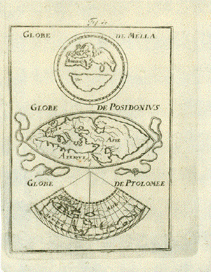
"Globe de Mella" Copper engraving map by Mallet
ca 1690. 14 x 10 cm ( 5.5 x 3.9 ") $ 85.00 minus 30% Discount = $ 59.50 Order Nr. WORLDMAP252715 |
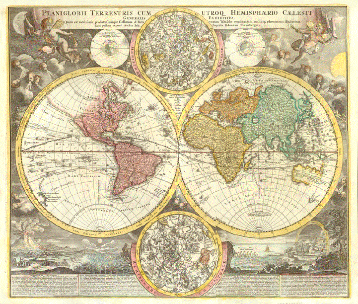
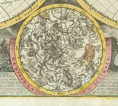
|
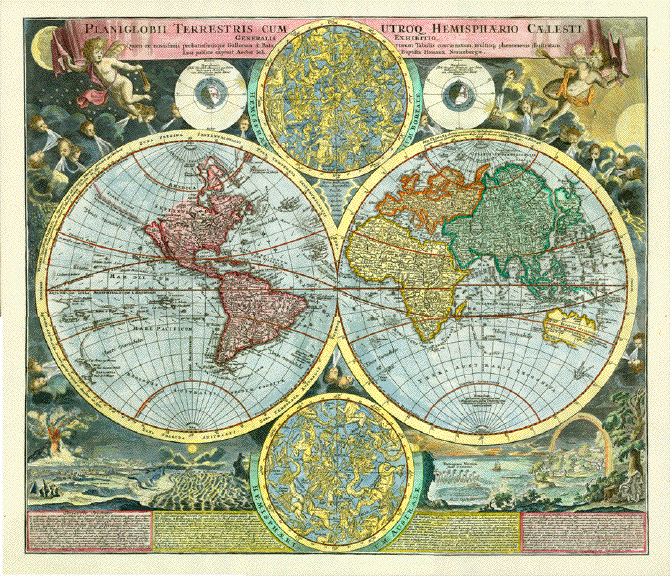
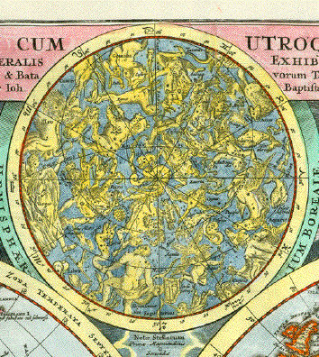
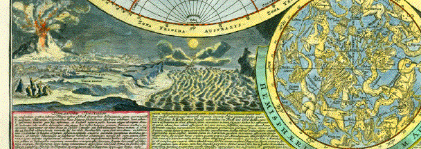
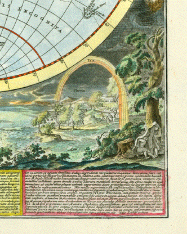
"Planiglobii Terrestris cum Utroq Hemisphaerio Caelesti Generalis Exhibitio" Hand-colored copper etching Published in the first atlas by Johann Baptist Homann (1664-1724) Nuremberg, 1707 This early map of the world by Homannbased on the world map by David Funck (1642-1709). It is the only map by Homann with California shown as an island. This decorative map has the two globes with the zodiac of the northern and the southern hemispheres. And, at the basis under the hemispherical depictions of the world, Homann shows natural happenings on earth, such as an eruption of a volcano, a flooding, vortex and swirl of an ocean with a sinking sail vessel and a rainbow. The two globes are surrounded by wind blowing putti. Upper left corner shows the moon, on right side of map the shining sun. Very decorative and quite rare. Nice hand-coloring. Centerfold
has been flattened. Good condition. 48.8 x 56.5 cm (ca. 19.2 x 22.2") $ 3500.00 minus 30% Discount = $ 2450.00 Order Nr. WORLDMAP252882 |
|
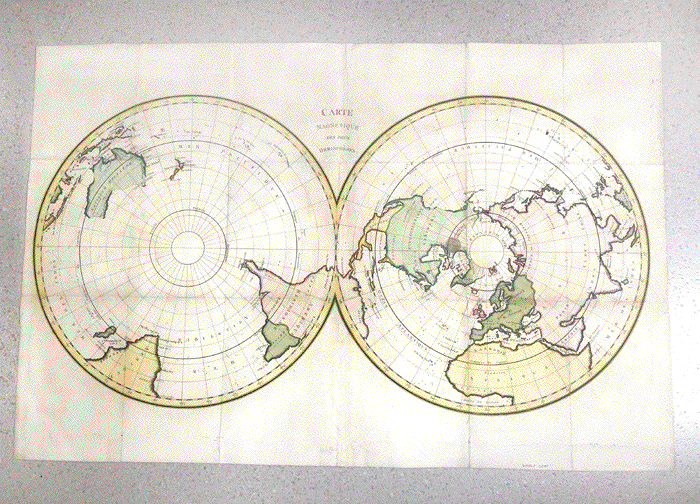
"Carte Magnétique des deux Hemisphères". Copper etching ca 1780. Modern hand coloring. This map shows the two polar regions and bordering countries. Notice that the polar regions were still somewhat unknown. The are many small crosses in the oceans for missed ships or shipwrecks. Map has folds to fit book size. some rubbing along folds. Repairs on margin edges on fold lines. Repair in upper right corner and on right margin side. This crease reaching from upper margin edge to title. Overall condition is otherwise Good. 64 x 97 cm ( 25.1 x 38.1 ") Diameter of circles: 48 cm ( 18.8 ") $ 680.00 minus 30% = $ 476.00 Order Nr. WORLD MAP 2201 |
|
"Die erste General Tafel / die Beschreibung und den Zirkel des ganzen Erdrichs un Meeresinnhaltende." Woodcut by Sebastian Münster, um 1550 for his "Cosmographia". German edition of this famous map which was the standard world map until Abraham Ortelius published his first atlas in 1570. Man shows the known world at the time. Notice that Antarctica and Australia are defined with large land masses. Africa is depicted much as we know it, but the Americas are still depicted with unknown boundaries. Decorative leaf designs in the corners. Text on map is Early German. Verso: Text in German. Map has overall age toning and darker browning along margin edges. The margin edges are frayed with small tears. Some have been repaired. The impression is a bit weak. Centerfold has been reinforced and small repairs made. Considering that it is more than 450 years old, this map is in Almost Good condition. 30.9 x 36 cm ( 12.2 x 14.2 ") Order Nr. WORLD MAP 2206 SOLD |
|
"Map Monde ou Description Generale du Globe Terrestre" Double hemisphere world map. Hand-colored copper etching by Henri Abraham Chatelain (1684-1743) Published in "Atlas Historique ou nouvelle introduction a l'histoire, a la chronologie & a la géographie ancienne & moderne" Amsterdam, 1705-1720 Upper left: The sun according to Kircher Upper right: The Moon according to Cassini Some discovery voyages. California depicted as an island. Below map legend Condition: Margins have several repairs, except for one in lower margin not reaching into image. The one tear at bottom reaches 1 and 1/2 inch into legend 34 x 44 cm including legend (ca. 13.4 x 17.3") 22,5 x 44 cm without the legend (ca. 8.9 x 17.3") $ 900.00 minus 30% Discount = $ 630.00 Order Nr. WORLDMAP252916 |
|
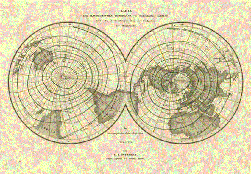
"Karte der Magnetischen Meridiane und Parallel-Kreise.......".Steel etching after the design by L. I. Duperrey, ca 1860. Some of the lines are hand colored. Map shows information concerning magnetic fields. A few hardly visible scattered spots. Hardly visible centerfold. Lines are colored somewhat unevenly. Overall condition is otherwise Almost Very Good. Page size: 23.5 x 29 cm (9.2 x 11.4 ") $ 75.00 minus 30% Discount = $ 52.50 Order Nr. POLARMAP 2188 |
|
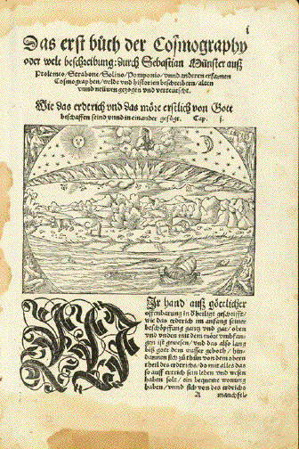
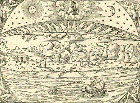
Creation of the World - "Wie das erdtrich und das moere erstlich von Gott beschaffen seind unnd ineinander gefuegt" Woodcut. Page 1 Chapter 1 of "Cosmographia" by Sebastian Muenster (1488-1552) This is Sebastian Muenster's mimesis of God's Creation History (Genesis) Published in Basel, 1553 In the German language. God the Father on top of His creation among sun, moon and stars. God created the heavens and the earth etc. Fire came down from heaven, the birds in the sky� Muenster condenses the biblical narrative of Creation of the World into one picture - leaving out, however, the creation of Adam and Eve. There are water stains in top, left ad bottom margin. The bottom margin has a repair from long ago. Please look at image. Light general age toning. Other traces of age and use. The image of Creation in very good condition and very good impression. Verso: Continuation of text from page 1. Page size: 31 x 20 cm (ca. 12.2 x 7.9") $ 480.00 minus 30% Discount = $ 336.00 Order Nr. WORLD253022 |
|
"Planiglobii Terrestris cum Utroq Hemisphaerio Caelesti Generalis Exhibitio, ......." Copper engraving map by Johann
Baptist Homann, published in Nuermberg 1720. In the upper corners are
decorative putti blowing the breath of life into the world
globes. The vertical centerfold has
been professionaly flattened so as to be invisible Map image: 48 x 56 cm ( 18.8 x 22 ") Order Nr. WORLD251512 SOLD |
|
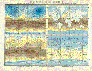
"Temperaturkarte der Erde" Divided in four parts: Upper left: Temperatur ind Passate I'm Januar - Temperature and Passat winds in January Upper right: Meeres-Temperatur im Januar - Ocean temperature in January Lower left: Temeperatur und Passate I'm Juli - Temperature and Passat winds in July Lower right: Regenzonen ind Orkane - Rain zones and hurricanes Wood engraving. Printed in color. Including description in the German language Published by Bibliographisches Institut Hildburghausen. Ca. 1880 Clean and in very good condition. Vertical centerfold. 15,5, x 21,4 cm (ca. 6.1 x 8.4") $ 70.00 minus 30% Discount = $ 49.00 Order Nr. WORLD251168 |
|
"Darstellung Der Isodynamischen Linien". Steel etching by Capitain Duperrey, ca 1860. Original outline coloring. A scientific map showing the isodynamic lines. Hardly visible centerfold. Very light browning in lower right area. General condition is Almost Very Good. Page size: 23.5 x 29 cm (9.2 x 11.4 ") $ 45.00 minus 30% Discount = $ 31.50 Order Nr. WORLD MAP 2198 |
|
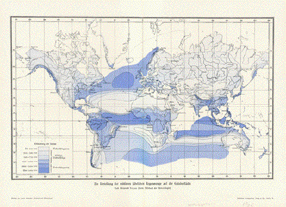
"Die Verteilung der mittleren jaehrlichen Regenmenge auf der Erdoberflaeche" ( the yearly rainfall ) Chromolithograph after Alexander Supan, published 1903. Vertical centerfold. 21 x 34.5 cm ( 8.2 x 12.4 ") $ 35.00 minus 30% Discount = $ 24.50 Order Nr. WORLD247614 |
|
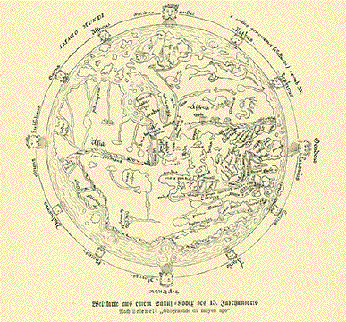
"Weltkarte aus einem Sallust Kodex fes 15. Jahrhunderts" Wood engraving published ca 1900. Reverse side is printed. Diameter of map: 12 cm ( 4.7 ") $ 40.00 minus 30% Discount = $ 28.00 Order Nr. WORLD250466 |
|
"Cook's Reisen in der Suedsee" Wood engraving published 1885. Reverse side is printed. Natural age toning. 11 x 19 cm (4.3 x 7.4 ") Order Nr. WORLD252676SOLD |
|
"Topografia Vignozzi" Copper engraving by Vignozzi in Livorno. Dated 1832. Hand coloring. Above the two globes are
diagrams of the "Sistema di Tolomeo", "Sistema di
Copernico" Map has folds to fit original
atlas size.. Left fold is lightly browned with An interesting map as there are so few from Italy. Page size: 29 x 46 cm ( 11.4 x 18.1 ") $ 640.00 minus 30% Discount = $ 448.00 Order Nr. WORLDMAP249732 |
|
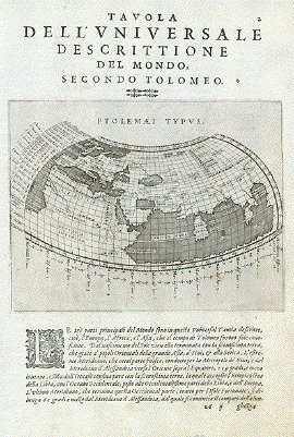
"Tavola Dell'Universale Descrittione Del Mondo, secondo Tolomeo" Shirley 193 World Map Magini / Ptolemy Type of print: Copper etching Artist: Girolamo Porro After: Claudius Ptolemy Published in:"Geografia cioe Descrittione Universale della Terra" Publisher: Gio. Battista & Giorgio Galignani Fratelli First published in: "Geographia" von Claudius Ptolemy Edition: Italian edition Editor: Giovanni Antonio Magini (1555-1617) Text: Italian. Complete on front and reverse side Published in: Venice Date: 1598 Measurements: Map size: Ca. 13,5 x 17 cm (ca. 5.3 x 6.7") Page size: Ca. 28,5 x 19 cm (ca. 11.2 x 7.5") Condition: Near perfect. Very minor traces of age. $ 420.00 minus 30% Discount = $ 294.00 Order Nr. WORLD236458 |
|
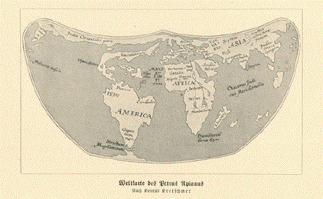
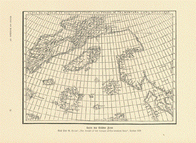
"Weltkarte des Petrus
Apianus" 7.5 x 13 cm ( 2.9 x 5.1 ") ***** Reverse side.
"Karte der Brueder Zeno" 13 x 17.5 cm ( 5.1 x 6.8 ") Interesting map with Sweden and
Norway on the right side. In the center are Iceland,
Estland These maps were published 1900. $ 45.00 minus 30% Discount = $ 31.50 Order Nr. WORLDMAP248792 |
|
"Erdtafel des Herodot" Wood engraving of a map after
the Greek geographer and auther Herodot. 10.5 x 16 cm (4.1 x 6.2") $ 45.00 minus 30% Discount = $ 31.50 Order Nr. WORLDMAP255436 |
|
"Map of the World showing the geographical distribution of the principle members of the Animal Kingdom" AND "Map of the World illustrating the productive industry of various countries & exhibiting the principal features of Commerce and Navigation" Type of print: Lithograph Color: Original hand coloring Publisher: George W. Colton Published in: "Colton's Atlas of the World illustrating physical and political geography" Published: New York, 1856 Upper map with inset: "Bird Map" Condition: Light general age toning. Very attractive, bright colors. Reverse side is blank. A decorative bordure frames this attractive map. 40 x 26,5 cm (ca. 15.7 x 10.4") $ 80.00 minus 30% Discount = $ 56.00 Order Nr. WORLD 239547 |
|
"Eastern Hemisphere"
"Western Hemisphere" Two maps dated 1875 showing the two hemispheres. At the bottom of each map is a color guide showing plains, plateaus, very high land, volcanos and the direction of currants. Both maps, especial the "Western Hemisphere" have a few spots in the magins. Page size: 30.5 x 24,5 cm ( 12 x 9.6 ") Price for the two maps; $ 120.00 Order Nr. WORLD249730 |
|
"Tableau analytique des differens sytemes du Monde dresser d'apres les relations plus recentes avec la Division Oceanique" Type of print: Copper etching Color: Original borderline hand coloring Author: Felix Delamarche Publication: "Atlas de la Geographie Ancienne du moyen age et moderne" Published: Paris, 1829 Condition: Some small repairs on margin edges. Clean. Minor traces of age and use. Page size: 30 x 45,5 cm (ca. 11.8 x 17.9") $ 140.00 minus 30% Discount = $ 98.00 Order Nr. WORLDMAP239277 |
|
"Verteilung des Wassers auf er Erde" ( distribution of water ) Wood engravings on a page of
text about water ca 1880. Hand coloring. Size of the image above: 16 x 8 cm ( 6.2 x 3.1 ") $ 40.00 minus 30% Discount = $ 28.00 Order Nr. WORLD249723 |
|
"Planisphere" Steel engraving map by Th.
Duvotenay, 1840. 18 x 23 cm ( 7 x 9 ") $ 65.00 minus 30% Discount = $ 45.50 Order Nr. WORLD249793 |
|
"Meerestroemungen" Detailed map of the ocean
currents. Published 1895. 22 x 28 cm ( 8.6 x 11 ") $ 45.00 minus 30% Discount = $ 31.50 Order Nr. WORLD249031 |
|
L'Orbit annuelle de la Terre autour du Soleil. Copper engraving by Back (Jakob
Conrad Bach), ca 1770. 13.5 x 20.5 cm ( 5.3 x 8 ") Order Nr. ASTRONOMY8240SOLD |
|
"Karte der beyden Halbkugeln welche den Magnetischen Æquator und die Abweichingslinien für beyde Magnetaxen nach der ersten Eulerschen Theorie vorstellt entworfen von C. Hansteen". Copper etching by Christopher Hansteen (1784-1873), published 1819. Map shows the various magnetic fields according to the Euler Theory. Map has folds to fit book size. Light browning and spotting along margin edges. Upper margin is narrow. Overall condition is otherwise Much Better than Good. The diameter of each circle is 19 cm (7.4 "). Page size: 23 x 43.5 cm ( 9 x 17.1 ") $ 350.00 minus 30% Discount = $ 245.00 Order Nr. WORLD MAP 2211 |
|
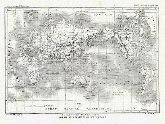
"Carte et Intineraire du Voyage" Wood engraving by Erhard, 1868. This map shows the route of the voyage around the world of Comte de Beauvoir 1868-1869. There are lines on the map showing the voyage route.
20.5 x 30.2 cm ( 8 x 11.8 ") $ 35.00 minus 30% Discount = $ 24.50 Order Nr. WORLDMAP239533 |
|
Sale! Discount! 30% Discount on All maps with a WORLDMAP number on this page! We accept reasonable offers! Visit us at the following sites: https://lovelyantiqueprints.com twitter.com/philographikon2 |
|
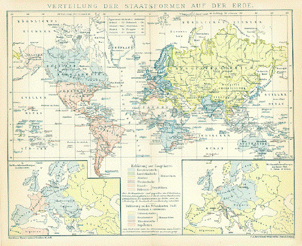
"Verteilung Der Staatsformen
Auf Der Erde" Interesting map showing the various forms of government at the time. This includes various forms of monarchies and republics. Wood engraving printed in color 1895. Vertical centerfold. Light age toning. 21.7 x 28 cm ( 8.5 x 11 ") $ 30.00 minus 30% Discount = $ 21.00 Order Nr. WORLD240118 |
|
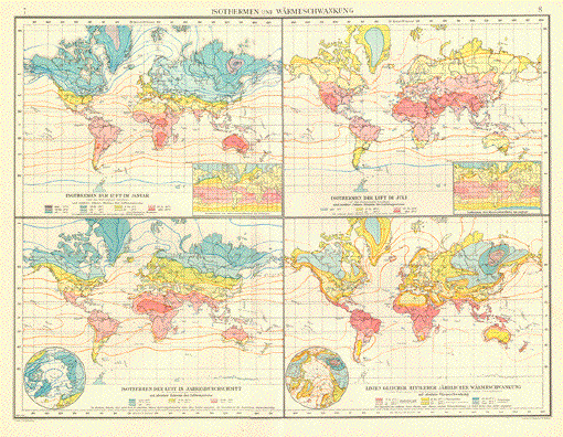
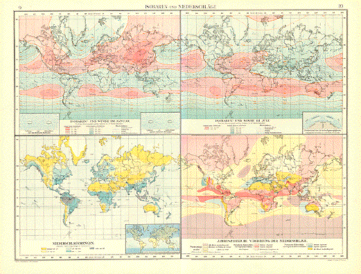
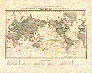
"Isothermen un Warmeschwangung" A very interesting world map dealing with the Isotherms and Warm temperature changes ( global warming ). Published in 1899. Vertical centerfold. Map image: 38 x 50 cm 14.9 x 19.6 ") $ 90.00 minus 30% Discount = $ 63.00 Order Nr. WORLDMAP248849 |
|
"Isobaren und Niederschlaege" A very interesting world map dealing with the Isobaren and Wind and Rain changes6 Published in 1899. Vertical centerfold. Map image: 38 x 50 cm 14.9 x 19.6 ") $ 90.00 minus 30% Discount = $ 63.00 Order Nr. WORLDMAP248849 |
|
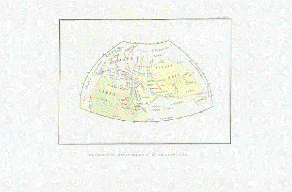
"Geografis sistematica d'Erastostene" The World by Erasthostenes (ca. 275 B.C. - 194 B.C.) Lithograph with original hand coloring Published in �Atlante di Geografie Universale" (Atlas of Universal Geography) By Francesco Constantino Marmocchi (1805-1858) Published in Florence, Firenze, Florenz, 1840 Erasthostenes' view on the �WORLD" comprised Europe (including Great Britain), North Africa, Arabia, the Near East and Middle East, Central Asia, India and TAPROBANA! (Sri Lanka) Clean. Very nice original hand coloring. Excellent condition. Map image:15,8 x 22 cm (ca. 6.2 x 8.7") $ 300.00 (Please look for discount at top of this page. Here $ 210.00) Order Nr. WORLDMAP255472 |
|
"Die Verteilung der Vulkane ueber die Erde" Wood engraving printed in color
1902. On the reverse side is an image of the Eruption on the
island of 12.5 x 20.5 cm ( 4.9 x 8 ") $ 25.00 minus 30% Discount = $ 17.50 Order Nr. VOLCANO247380 |
|
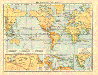
"Das Zeitalter der Entdeckungen" ( age of discovery ) Map shows the routes of the great discovers of the 15th and 16th Century. Published 1896. Vertical centerfold. 22 x 29 cm ( 8.6 x 11.4 ") $ 35.00 minus 30% Discount = $ 24.50 Order Nr. WORLD248104 |
|
"Athanasius Kirchers
physikalische Erdkarte mit angabe der Meerestroemungen und
Vulkangebiete" Wood engraving made after
earlier map 1655. This was published ca 1900. 17 x 32 cm ( 6.6 x 12.5 ") $ 45.00 minus 30% Discount = $ 31.50 Order Nr. WORLDMAP248788. |
|
"Planispherium Globi Terrestris" Copper etching by Tobias Conrad Lotter ( (1717-1777) after Tobias Lobeck for the "Atlas Geographicus portabilis" (Pocket-size atlas) published 1760-1762. Original hand coloring. Fine little map showing the world as it had been explored up to this time. Binding marks on left margin edge. Light browning in margins. Otherwise Better than Good condition. 9.4 x 12.3 cm ( 3.7 x 4.8 ") $ 220.00 minus 30% Discount = $ 154.00 Order Nr. WORLDMAP2233 |
|
"Mappe-Monde ou Carte Génerale de toutes les Parties connues de la Surface du Globe,....." Copper etching by Charles Françoise Delamarche(1740-1817). Delamarche was the sucessor to Robert de Vaugondy. This map was published ca 1790. Fine modern hand coloring. World map showing the geography as it was then known. Map has some interesting historical notes that give information about discovery. Map has vertical center fold. Very light creases along lower center fold. A few trivial spots in margins. Tiny creases on lower right margin corner. 24.5 x 39.7 cm ( 9.6 x 15.6 ") Order Nr. WORLD MAP 2238 SOLD |
|
Orbis Veteribus Notus Steel etching from "Neuster
Zeitungs Atlas. Alter und Neuer Erdkunde" by J. Meyer, ca
1855. Diameter of circle: 22 cm ( 8.6
") $ 75.00 Order Nr. EUROPEMAP2214 |
|
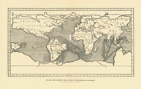
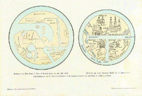
"Weltkarte des Abu Isak al Farsi al Istachri ( etwa um das Jahr 950. Weltkarte aus einem Leipziger Kodex des 11 Jahrhunderts" Wood engraving by Dr. Konrad
Kretschmer of very old maps. Published 1900. Page size: 18 x 28 cm ( 7 x 11 ") $ 75.00 minus 30% Discount = $ 52.50 Order Nr. WORLD254614 |
|
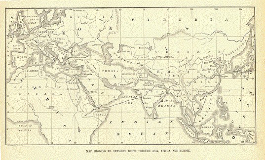
"Map Showing Mr. Seward's Route Through Asia, Africa, and Europe" Wood engraving 1873. Two vertical folds to fit original book size. 15.5 x 27.5 cm ( 6.1 x 10.8 ") $ 30.00 minus 30% Discount = $ 31.00 Order Nr. WORLDMAP246264 |
|
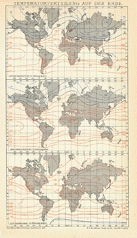
"Temperaturverteilung auf der Erde" Wood engraving 1895 shows the temperature at different times of the year. 23 x 12.5 cm ( 9 x 4.9 ") $ 25.00 minus 30% Discount = $ 17.50 Order Nr. WORLDMAP246188 |
|
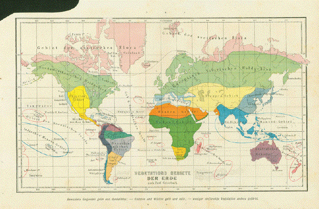
"Vegetatsions Gebiete cer Erde nach Prof. Grisebach" Map shows the world distribution of various forms of vegetation by color. One vertical fold to fit original book size and a margin cutout in upper left for binding space. Image: 18 x 30.5 cm ( 7 x 12") $ 55.00 minus 30% Discount = $ 38.50. Order Nr. WORLD255762 |
|
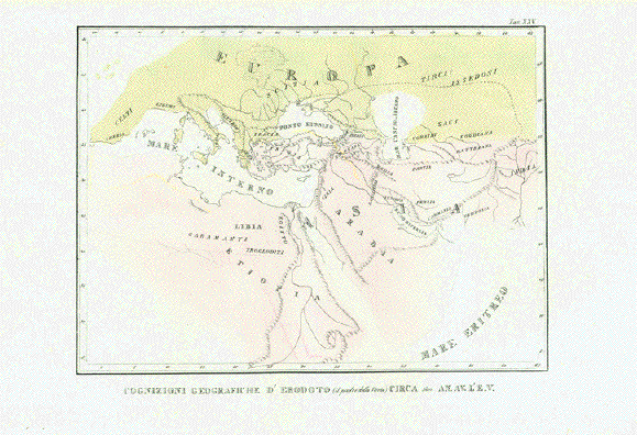
"Cognizioni Geografiche d'Erodoto (il padre della Storia) circa 500 AN. Av. L'e.V." The "World" by Herodotus (ca. 490 B.C. - 420 B.C.) Lithograph with original hand coloring Published in �Atlante di Geografie Universale" (Atlas of Universal Geography) By Francesco Constantino Marmocchi (1805-1858) Published in Florence, Firenze, Florenz, 1840 Herodot's conception and view of "The World", at ca. 500 B.C., was naturally restricted to Southern Europe, Asia Minor (Turkey), The Near and Middle East, Arabia, Egypt. But isn't it amazing how well defined Herodot's conception of HIS World was? Clean. Very nice original hand coloring. Excellent condition. Map image:19,3 x 26,2 cm (ca. 7.5 x 10.3") $ 340.00 (Please look for discount at top of this page. Here 30% = $ 238.00) ORDER Nr. WORLD255471 |
|
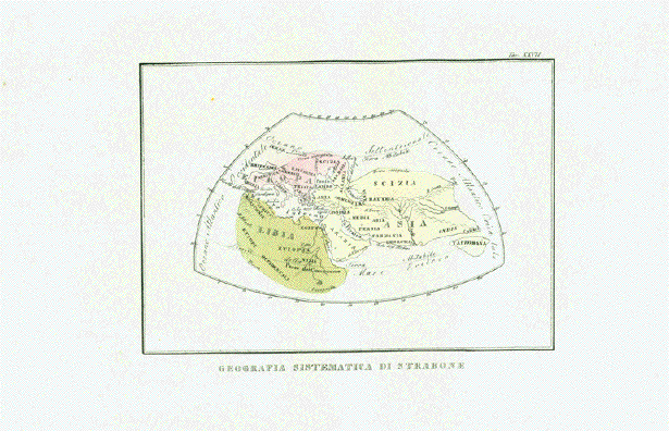
"Geografia Sistematica di Strabone" World Map by Strabo (ca. 63 B.C. - 23 A.D.) Lithograph with original hand coloring Published in �Atlante di Geografie Universale" (Atlas of Universal Geography) By Francesco Constantino Marmocchi (1805-1858) Published in Florence, Firenze, Florenz, 1840 Europe with Great Britain and
Ireland placed oddly. Arabia, EGYPT North Clean. Very nice original hand coloring. Excellent condition. Map Image:15,5 x 22,2 cm (ca. 6.1 x 8.7") $ 300.00 (Please look for discount at top of this page. Here $ 210.00) Order Nr. WORLD255470 |
|
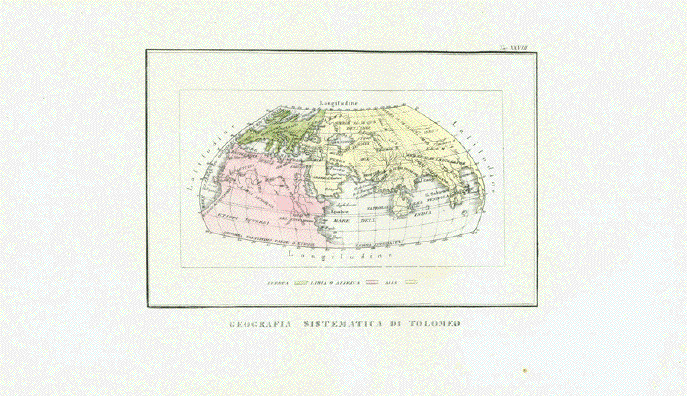
"Geografia Sistematica di Tolomeo" Conception of the �World" by Claudius Ptolemy (ca. 100 A.D. - after 160 A.D.) Lithograph with original hand coloring Published in "Atlante di Geografie Universale" (Atlas of Universal Geography) By Francesco Constantino Marmocchi (1805-1858) Published in Florence, Firenze, Florenz, 1840 Showing Europe, North Africa, Arabia, Near East, Middle East, Central Asia. India, Taprobana (Sri Lanka oversized, South East Asia Clean. Very nice original hand coloring. Excellent condition. Map image: 14,8 x 22,5 cm (ca. 5.8 x 8.9") $ 300.00 (Please look for discount at top of this page. Here $ 210.00) Order Nr. WORLD255469 |
|
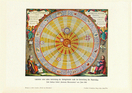
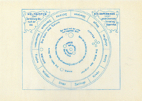
"Faksimile einer alten
Darstellung des Weltgebaeudes nach der Vorstellung des
Kopernikus" Image: 14 x 17 cm ( 5.5 x 6.6 ") Below is a transperant tissue paper to put on the map for more information:
Chromolithograph published 1900. $ 35.00 minus 30% Discount = $ 24.50 Order Nr. WORLD247800 |
|
"Verteilung der Vulkane auf die Erde" ( Distribution of Volcanoes on the Earth ) Wood engraving map printed in color, 1890. Vertical centerfold to fit original book size. 21 x 27.5 cm ( 8.2 x 10.8 ") $ 35.00 Order Nr. VOLCANO245259 |
|
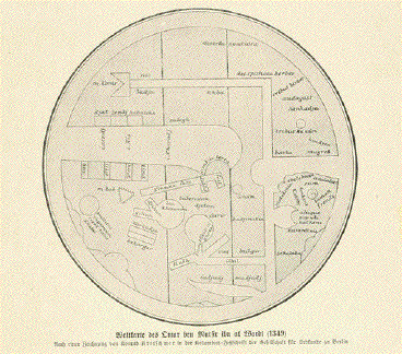
"Weltkarte des Omar ben Mutsir al Wardi ( 1349 ) Wood engraving after a drawing
by Konrad Kretschmer of an ancient world map. Diameter of map: 13 cm ( 5.1") $ 45.00 minus 30% Discount = $ 31.50 Order Nr. WORLD254830 |
|
"Vergleichender Uebersicht
der Bedeutensten Stromlaengen".
Steel etching from J. Meyer,
1859. Map has horizontal centerfold. Clean, strong image. 25 x 18 cm ( 9.8 x 7") Order Nr. WORLD MAP254787SOLD |
|
"Planisphere" Steel engraving by Th.
Duvotenay ca 1840. 17.5 x 22.5 cm ( 6.8 x 8.8 ") $ 40.00 minus 30% Discount = $ 28.00 Order Nr. WORLDMAP240914 |
|
"Erdkarte nach Kosmas Indicoplenstes" Wood engraving published
1881.Below the image and on the reverse side Image: 4.5 x 10 cm ( 1.7 x 3.9") $ 35.00 minus 30% Discount = $24,50. Order Nr. WORLD255822 |
|
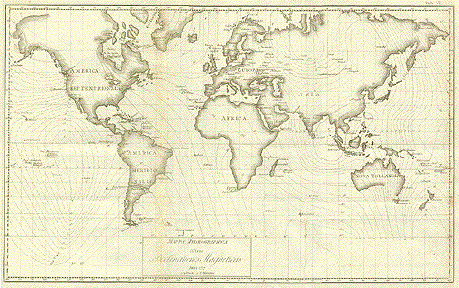
"Mappa Hydrographica sistens Declinationes Magneticas Anni 1787 constructa a C. Hansteen." Copper etching by Christopher Hansteen (1784-1873), published in an Italian atlas ca 1830. Map gives information from the known magnetic researcher, C. Hansteen. This map shows the magnetic declinations in all areas of the world. Map has folds to fit book size. Some light browning and smudging along fold lines. Left and right margins have been added. A few small creases and spots. 31 x 50.2 cm ( 12.2 x 19.7 ") $ 260.00 minus 30% Discount = $ 182.00 Order Nr. WORLD MAP 2236 |
|
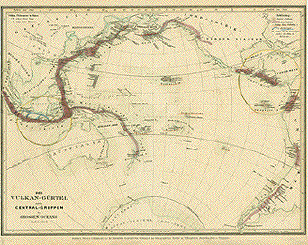
"Der Vulkan-Guertel und die Central-Gruppen des Grossen Oceans." Steel etching after L. von Buch from "Neuster Zeitungs Atlas. Alter und Neuer Erdkunde" by J. Meyer, ca 1855. Original hand outline coloring. Map shows the volcano ring around the Pacific Ocean.The areas of active volcanos are underlined in orange. Two circled areas show the main goups of volcanos. Map has overall light age toning. No Side margins. 21.5 x 29 cm ( 8.4 x 11.4 ") $ 75.00 Order Nr. VOLCANO2250 |
|
"Die Vulkanischen Erscheinungen der alten Welt, in und um den Atlantischen Ocean." Steel etching from "Neuster Zeitungs Atlas. Alter und Neuer Erdkunde" by J. Meyer, ca 1855. Original hand coloring. This map shows the volcano areas in Europe and and around the Atlantic Ocean. Map has overall light age toning. No side margins. 21 x 28 cm ( 8.2 x 11 ") Order Nr. WORLDMAP2251 SOLD |
|
Die Isothermkurven Der Noerdlichen Halbkugel." Steel etching from "Neuster Zeitungs Atlas. Alter und Neuer Erdkunde" by J. Meyer, ca 1855. Original hand outline coloring. This interesting map shows the isothermic lines of the northern hemisphere with the North Pole in the center. At the bottom are the diagrams of the highest mountains and their snow limits. In the lower left is the New World and in the lower right is the Old World. Diameter of circle: 18.5 cm (
7.2 ") $ 70.00 Order Nr. POLAR2221 |
|
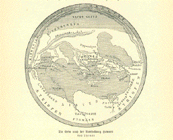
"Die Erde nach der Vorstellung Homers" (the earth after the concept of Homer) Wood engraving on a page of
text published ca 1900. Below the image and on the reverse
side Image diameter: 11 cm ( 4.3 ") $ 35.00 minus 30% Discount = $ 24.50 Order Nr. WORLD255577 |
|
�Veteris Orbis Climata ex Strabone". Copper etching of a Ptolemaic map initiated by Strabo and most likely published by Christopher Cellarius (1638 - 1707). Ca.1700. The map, decoratad with a ribbon title and eight winds blowing from all directions, shows the �Old World" in which Strabo defined his assumptions of climatic regions on earth. The map has been carefully and attractively hand colored in recent time. Map is clean, has wide margins and is in very good condition. Verso no text 30.2 x 44.6 cm (11.9 x 17.6") $ 620.00 Order Nr. WORLDMAP2239 |
|
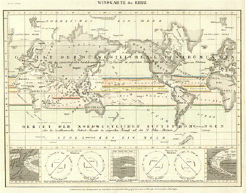
"Windkarte der Erde". Steel etching from the Bilbiographisches Institut zu Hildburghausen, ca 1870. Original hand outline coloring. This is a map of the major wind directions with detailed graphic explanations at the bottom. Right margin is a bit narrow. Light browning along upper and lower margin edges. Condition is otherwise Almost Very Good. 19.3 x 25.7 cm ( 7.6 x 10.1 ") $ 55.00 minus 30% Discount = $ 38.50 Order Nr. WORLD MAP 2192 |
|
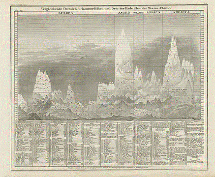
Vergleichende Uebersicht bekannter Hoehen und Orte der Erde ueber der Meeres-Flaeche. Steel etching from "Neuster Zeitungs Atlas. Alter und Neuer Erdkunde" by J. Meyer, ca 1855. Map diagrams the various mountains from around the world. Below th image is a list of the mountains with their respective elevations. Very minor signs of age in margins. 21.5 x 24.5 cm ( 8.4 x 9.6 ") $ 90.00 minus 30% Discount = $ 63.00 Order Nr. WORLDMAP249729 |
|
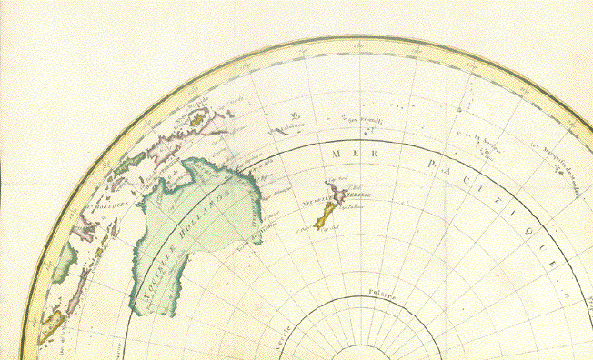
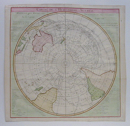
"Carte de L'Hemisphere Austral Montant Les Routes Des Navigateurs Les Plus Célebres Par le Capitaine Jacques Cook". Copper etching by Benard from "Voyages de Cook", ca 1780. Modern hand coloring. This map of the southern hemisphere shows the exploration routes of great voyagers such as Captain Cook, Furneaux, Bouvet, Wallis, Halley and Bouganville. In the four corners is information pertaining to the map. Map has folds to fit book size. Centerfold has been partially reinforced. Light spotting in margins. General condition is Almost Very Good. 53 x 53 cm ( 20 ") $ 1700.00 minus 30% Discount = $ 1190 Order Nr. WORLD MAP 2204 |
|
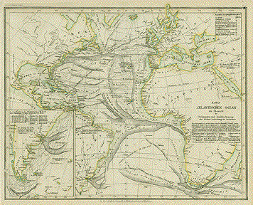
"Karte vom Atlantischen
Ocean Zur Uebersicht der Stroemungen und Handelsstrassen der
Waerme Verbreitung des Seebodens"
Steel etching from "Neuster Zeitungs
Atlas. Alter und Neuer Erdkunde" by J. Meyer, ca 1855. Map has a small repaired worm hole in upper right corner. Vertical centerfold. 21.5 x 27.3 cm ( 8.4 x 10.7 ") $ 75.00 Order Nr. ATLANTICMAP2241 |
|
Sale! Discount! 30% Discount on All maps with a WORLDMAP number on this page! We accept reasonable offers! Visit us at the following sites: https://lovelyantiqueprints.com twitter.com/philographikon2 |
|
"Westliche und Oestliche Halbkugel" Viewing the world from several
aspects. On the left side are two small insets of the Island
of St. Paul Published 1899. Vertical centerfold. Map has repairs in lower margin on the centerfold. Map image 38 x 51 cm ( 14.9 x 20 ") Order Nr. WORLD248845 SOLD |
|
"Verbreitungsbezirke Der Wichtigsten
Kulturgewaechse Nebsts Andeutungen Ueber Den Lauf Der
Isotheren Und Isochimenen". Steel
etching from "Neuster Zeitungs Atlas. Alter und Neuer
Erdkunde" by J. Meyer, ca 1855. The map shows the various weather patterns with the growing areas. On the upper sides of the map are the various plants with their Latin names. Clean map in good condition. 22 x 27.3 cm ( 8.6 x 10.7 ") $ 75.00 Order Nr. WORLDMAP2260 |
|
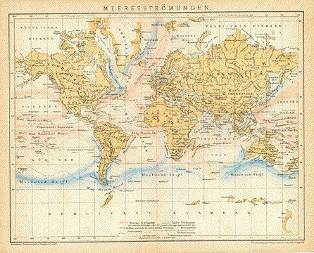
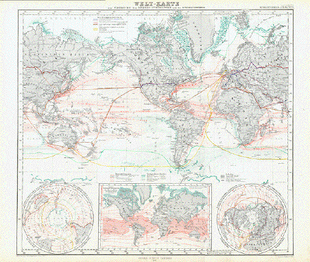
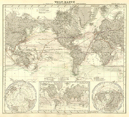
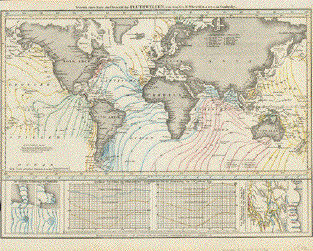
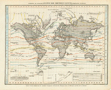
" Welt-Karte zur Uebersicht der Meeres-Stroemungen und des Schnellverkehrs" Steel enraving by Herman Berghaus, 1867 for Stieler. Printed in color. Published1871. Very interesting map showing the ocean currants around the world and the fastest shipping routes of the time. The various ocean currants are named in German. The colors represent the warm and cold ocean currants. Also shown are the coastal ice packs and floating icebergs. The main overland postal routes are shown by red lines and the railroad routes by blue lines. Map is in very good condition. Vertical centerfold. 34.3 x 38.5 cm ( 13.5 x 15.1 ") Order Nr. WORLDMAP236450 SOLD |
|
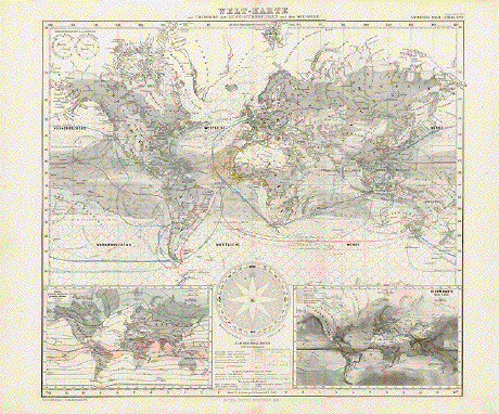
"Weltkarte zur Uebersicht der Luft Stroemungen und der See Wege ". Steel enraving by Herman Berghaus, 1867 for Stieler. Printed in color. Published1871. Map shows the air currants ( winds ) in all parts of the world. The colored lines represent various sea routes. In the lower left is an inset showing the warmth of the air during the year. In the lower right is an inset showing the rainfall around the world. In the lower area is a ship´s compass. Map is in good condition except for a small repair on the lower centerfold. $ 70.00 Order Nr. WORLDMAP236472 |
|
"Welt-Karte zur Übersicht der Meeres-Stromungen und des Schnellverkehrs". Steel etching after Berghaus for "Stieler's Hand Atlas", dated 1880. Original outline coloring. This map shows the ocean currents in fine detail and some of the shipping routes of the time. On the lower left side is a global depiction of the South Pole and on the right lower corner the North pole. In the lower center is an inset showing sea temperatures. Map has a bit of light fraying on lower margin edge near centerfold. Some very light browing on margin edges. Other the condition is Almost Very Good. 33.5 x 38 cm ( 13.1 x 14.9 ") $ 50.00 Order Nr. WORLD MAP 2189 |
|
"Versuch einer Karte zur Uebersicht der
Fluthwellen, von dem Rev. W. Whewell, M.A.F.S. in
Cambridge. This ver interesting map shows the various tidal waves - tsunamis according to Rev. Whewell. In the lower right is a detail of Fundy Bay. No left margin. Light age toning. 21 x 28,5 cm ( 8.2 x 11.2 ") $ 50.00 Order Nr. WORLDMAP235476 |
|
"Die oestliche und die
westliche Halbkuegel der Erde" Wood engravings 1875. Reverse side is printed ( in German) with more geographical information about the earth. Minor spot in lower left. Page size: 28 x 21 cm ( 11 x 8.2 ") $ 25.00 Order Nr. WORLDMAP239850 |
|
"Land Halbkuegel Wasser Halbkuegel" Wood engravings 1875. Reverse side is printed. Page size: 28 x 21 cm ( 11 x 8.2 ") $ 25.00 Order Nr. WORLDMAP239851 |
|
Darstellung Der
Isodynamischen Linien Steel etching from "Neuster
Zeitungs Atlas. Alter und Neuer Erdkunde" by J. Meyer, ca
1855. Map image: 14 x 23.8 cm ( 5.5 x 9.3 " ) $ 45.00 Order Nr. WORLD235472 |
|
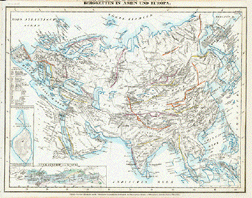
Bergketten in Asien und Europa (Mountain chains in Asia and Europe) Steel etching from "Neuster
Zeitungs Atlas. Alter und Neuer Erdkunde" by J. Meyer, ca
1855. 20.9 x 27.8 cm ( 8.2 x 10.9 ") Order Nr. WORLDMAP235488 SOLD |
|
Alexander von Humbolts´s System der Isotherm Kurven, in Mercator´s Projection Steel etching from "Neuster
Zeitungs Atlas. Alter und Neuer Erdkunde" by J. Meyer, ca
1855. 20.3 x 26 cm ( 7.9 x 10.2 ") $ 65.00 Order Nr. WORLDMAP235473 |
|
"Weltkarte" (Map of the World) Copper etching by J.N. Champion (Johann Galletti 1750 - 1828). Leipzig, ca. 1820. Hand coloring 20th century. Except for a tiny repaired hole in margin and a thin paper spot (extreme upper left corner) the condition is Very Good. Sheet size: 28.7 x 36.7 cm (11.3 x 14.4") $ 180.00 Order Nr. WORLDMAP234613 |
|
"Die Isothemkurven der Noerdlichen Halbkugel" Steel etching from "Neuster Zeitungs Atlas. Alter und Neuer Erdkunde" by J. Meyer, ca 1855. This map shows the isothemich curves of the northern half of the world. In the lower left are the highest mountains of the New World and in the lower right are the highest mountains of the Old World. Map has no left margin. Overall light age toning. 21 x 28.5 cm ( 8.2 x 11.2 ") $ 85.00 Order Nr. POLARMAP235474 |
|
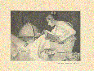
No Title Studying the world? Wood engraving made after a
painting by Barabino Image: 9 x 12.5 cm ( 3.5 x 4.9") $ 25.00 minus 30% Discount = $ 17.50 Order Nr. WORLD255895 |
|
"Oro-Hydrographische Erdkarte in Mercators Projektion" Oro-hydrographic world map Published in Meyers Kleiner Handatlas. Leipzig, 1892 Light general age toning. A small repaired tear in lower margin. Print in fine condition. 21 x 27.5 cm (8.3 x 10.8") $ 35.00 Order Nr. WORLD MAP 235671 |
|
"Tabula Geographica utriusque Hemisphaerii Terrestris .............". Copper etching by N.F. Sauerbrey, published in Berlin 1760. Original hand coloring. Map shopws the magnetic fields as studied in 1744. The information at the bottom of the map is Latin. The map has wide margins. Brown stains in upper corners. Browning on margin edges. Some spotting in margins. Rest of an ink stamp in upper right image. Vertical centerfold. General condition is Better than Good. 31.2 x 36.7 cm ( 12.2 x 14.4 ") Order Nr. WORLD MAP 2220SOLD |
|
"Die Verbreitung der
Menschenrassen nach F. Mueller un O. Peschel" Chromolithograph published 1895. The various races are shown with color and name at the bottom of the map. Vertical centerfold to fit original atlas size. Light overall age toning. 21.5 x 28 cm ( 8.4 x 11 ") Order Nr. WORLDMAP249026 SOLD |
|
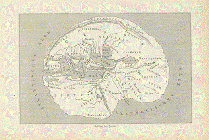
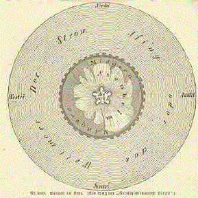
Welttafel der Edda Map from German Mythology
showing the land in the center surrounded by water named
Ising. Wood engraving in "Orbis
Pictus" published by Otto Spamer, 1874. Diameter: 10.7 cm ( 4.2 ") $ 45.00 Order Nr. WORLD 2213 |
|
"Commercial Map of the World". Wood engraving printed in color ca 1900. Very interesting commercial map showing railroad, steamship, sailing and caravan routes around the world. In the lower right is a key to the various colors on the map. In the lower left is a color key of the commercial routes. Vertical centerfold. Light browning on margin edges. Reverse side is printed. 27.5 x 44.5 cm ( 10.8 x 17.5 ") $ 35.00 Order Nr. WORLDMAP2261 |
|
"Mappa Hydrographica sistens Inclinationes Magneticas, Anni 1780 constructa a C. Hansteen." Copper etching by Christopher Hansteen (1784-1873), published in an Italian atlas ca 1830. The famous researcher of magnetic fields, C. Hansteen, shows the magnetic inclinations on this world map. Map has folds to fit book size. Some light browning on fold lines. Repaired tear in lower margin and on fold line. Small thin area in map image. Left margin has been added. Spotting in margins. Very minor, light spotting in image. 30.8 x 49 cm ( 12.1 x 19.3 ") $ 340.00 Order Nr. WORLD MAP 2235 |
|
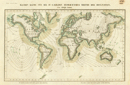
"Magnet - Karte Für die in 4 Jahren Beobachteten Werthe Der Declination". Steel etching by Adolph Ermau from "Neuster Zeitungs Atlas. Alter und Neuer Erdkunde" by J. Meyer, ca 1855. Original hand outline coloring. Map shows various observations of magnetic fields. Map has some scattered pin-point spotting. Around the margin edges are stains. Hand-written page number in upper right corner in spot. Condition is just Good. 14.2 x 24 cm ( 5.6 x 9.4 ") $ 55.00 Order Nr. WORLD 2217 |
|
"Die Erforschung des Weltalls" Wood engraving 1900. This is a facsimile of the title page of "Machina coelestis", 1673. 21 x 12.5 cm ( 8.2 x 4.9 ") $ 25.00 Order Nr. WORLD247805 |
|
|
"Geography" Copper etching from " A
Gentleman's Recreation" Here we have a fine abstraction from what we are used to when looking at world maps. This one is embedded into BlomeÔs idea of "Geography", a playful assembly of bits and pieces relating to measuring the world nearby and as a whole. The two-globe world map in the center shows California as an island, welcomed by collectors of this particularity in map making. At the bottom we find ourselves looking into a globe makerÔs workshop. An interesting and in more than one way special piece!
Margins are narrow. Right
margin has frayed edge. 38.2 x 23.2 cm ( 15 x 9.1 ") $ 420.00 Ordr Nr. WORLD 2208 SOLD |
|
"Carta Ridotta Del Globo Terrestre". Copper etching, anonymous Italian, dated. 1781. Modern hand coloring. A facinating aspect of this map is that Europe and Asia are shown on the left side. A little bit of Europe and Africa is on the right edge to give a sense of location. In both upper corners is a bit of Greenland. In the upper left is Iceland in green. Right margin has been added. Folds to fit book size. Light creasing in left margin. On the lower right margin corner are tiny brown spots. Upper margin is narrower. On the backside is brown spotting that is not visible on the fronside. Overall condition is Better than Good. 30.5 x 51.3 cm ( 12 x 20.1 ") $ 780.00 Order Nr. WORLD MAP 2187 |
|
"Carte de L'Ancien Continent". Steel etching by Ambrosie Tardieu for Buffon, 1840. Original outline coloring. Map shows what was known as the "Ancien Continent". The diagonal line shows the north-south axis of the time from Tartaria to the Cape of Good Hope. Map has a few light spots in margins. Otherwise Almost Very Good condition. 16.5 x 13.5 cm ( 6.4 x 5.6 ") $ 80.00 Order Nr. WORLD MAP 2224 |
|
"Erdkarte aus der Basler Ausgabe vom 1545 der Geographie des Ptolomaeus" A very decorative map after Ptolomaeus of Europe and much of Asia.. Published ca 1900. Reverse side is printed. 13.5 x 18 cm ( 5.1 x 7 ") $ 45.00 Order Nr. WORLDMAP249039 |
|
"Hyetographische Karte Der Erde" Steel etching from "Neuster
Zeitungs Atlas. Alter und Neuer Erdkunde" by J. Meyer, ca
1855. Very clean map. 20 x 23.8 cm ( 7.8 x 9.3 ") $ 55.00 Order Nr. WORLDMAP2249 |
|
"Erdkarte des Richard von
Haldingham aus dem 13. Jahrhundert" Wood engraving published ca 1900. Reverse side is printed. Map diameter 11 cm ( 4.3 ") $ 35.00 Order Nr. WORLD250465 |
|
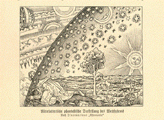
"Mittelalterische
phantastische Darstellung des Weltsystems" Wood engraving made after an older print. Published 1900. Reverse side is printed. 8.5 x 10.5 cm ( 3.3 x 4.1 ") Order Nr. WORLD247801SOLD |
|
"Umrisse der Pflanzengeographie". Steel etching from "Neuster Zeitungs Atlas. Alter und Neuer Erdkunde" by J. Meyer, ca 1855. Original hand coloring. Map shows the distribution of various plants in the world. At the top of the map are diagrams showing at what height various plants grow in the Andes, Teneriffa, Himalaya, Alps and Pyrenees, and in Lapland. Right and left margins are very, very narrow. Small crease in lower left margin corner.. 20.5 x 28.7 cm ( 8 x 11.3 ") Order Nr. WORLD 2243.SOLD |
|
"Planisphere" Steel engraving map by Th. Duvotenay. Published 1840. Two vertical folds to fit original book size. 18 x 23 cm ( 7 x 9 ") $ 40.00 Order Nr. WORLD250585 |
|
Upper image: "Erdtafel des Herodot". Lower image: Die erde nach den Anschauungen des Stratothenes". Wood engravings from "Orbis Pictus" by Otto Spamer, 1874. The upper image shows the world according to the descriptions of Herodot. It reaches as far east as the Indus and shows northern Africa. The lower image is a bit more extensive showing an unpropational large Srilanka (Taprobane) and reaching as far east as the Ganges. North of Britanien is the island of Thule. On the left are the Kasserides (Zinn Is.) - nowdays the Azores. Page has overall age browning and spotting in margins. Condition is Good. Page size: 28.5 x 21.5 cm (11.2 x 8.4 ") $ 50.00 Order Nr. WORLD2193 Reverse side of page. Upper image is the earth
according the learned of India.
|
Views of Towns and Cities Around the World
GARDEN-HORTICULTURE-CLASSICAL GARDENS
©Rainer Rauhut