Gilbreth

Antique Maps of Regional Italy (page 3)

A selection of our Italian maps from the 16th to the 19th century. Enjoy these masterpieces of cartographic art. Each map is described and illustrated. Please contact us if you are looking for a special map. Maps showing Sicily my be viewed on our page Antique Maps of Sicily.

Maps showing Sardinia with the Mediterranean area may be viewed at: Antique Maps of the Mediterranean.

Ordering and payment.

Lieferbedingungen

Sale! Discount!

30% Discount on All maps with an ITALIAMAPPA number on this page!

Take 30% off the listed price. !

"Dominum Venetum in Italia"

Type of print: Copper etching.

Publisher: Johannes Janssonius

Ciolor: Hand-colored (20th century)

Published in: Amsterdam

Date: Ca. 1660

Verso text: blank

Very light general age toning. Browning along centerfold. A few spots in margins.

Aria shown: From Lago Maggiore to Istria - from Brixen to Modena

Measurements: 37,3 x 49,7 cm (ca. 14.7 x 19.5")

Margins: wide

Price: $ 950.00

Order Nr. ITALIAMAPPA 241335


No title. - Mediterranean Sea (Western part)

From Portugal to Croatia. Norther Africa from Morocco to the Gulf of Gabes (Lesser Syrtis) in Tunesia.

Copper etching by Guillaume-Nicolas Delahaye (1725-1802)

Geographical place names etc: French Language

This map does not show the title cartouche. It was printed in two parts as a large wall map.
We have only the western part of the Mediterranean Sea. Since Delahaye's signature is in
the lower right corner of this map, it may be assumed that the map was created for one
of the French cartographers of the late 18th or early 19th century.

Very good condition with only minor signs of age and use.
Because of large size there are several vertical folds to fit atlas size.

Map image:49,7 x 80 cm (ca. 19.5 x 31.5")

$ 900.00 (Please look for discount at top of this page. Here: 30% = $ 630.00).

Order Nr. MEDITERRANEAN255142


"Territorium Tridentinum"

Type of print: Copper etching.

Publisher: Johannes Janssonius

Ciolor: Originially hand-colored

Published in: Amsterdam

Date: Ca. 1636

Verso text: Dutch

Condition: Very good. Very light general age toning. Centerfold repaired above and below image. Light fraying on margin edges.

Area shown: Focus Province of Trento

Measurements: 37 x 48 cm (ca. 14.5 x 18.9")

Margins: wide

Price: $ 850.00

Order Nr. ITALIA MAPPA 241333


"Sardinia Insula" The island of Sardinia

Type of print: Woodcut

Published in: Cosmographia

Author: Sebastian Muenster (1488-1552)

Published: Basel, Switzerland, 1544-1598 (continued after Muenster's death)

Reverse side: Fictional view of Naples damaged by an earthquake

Condition: Paper has general age toning. Margins are spotty. Right margin has stitch holes from binding. Impression is strong and very good!

Image: 25 x 14,8 cm (ca. 9.8 x 5.8")

$ 220.00

Order Nr. ITALIAMAPPA239129


"Carte de L'Italie Ancienne" . Steel etching by Pierre Tardieu for the "Atlas Universal", dated 1858. Original hand coloring.

The map shows ancient Italy, with the names of prehistoric peoples. The town and city names are of special historical interest.

Map has horizontal centerfold. Wide margins. On each end of the centerfold is a small, repaired tear on margin edge. A few very minimal spots in margins. General condition is otherwise Almost Very Good.

54.5 x 39.7 cm ( 21.5 x 15.6")

$ 180.00

Order Nr. ITALIAMAPPA1422


"Italia". Copper etching by Johann Bussemacher, ca. 1590. Modern hand coloring.

At first glance this map is very decorative with a sailing ship and a large imaginative fish in the wavy Tyrrhenian Sea, a pleasant title
cartouche and a compass in the lower right corner. Studying the map more closely, one appreciates the great detail in locations of cities
and rivers that were known in the 16th Century. Bussemacher's name is at the bottom of the map.Verso: Text in Latin.

Map has wide margins with minimal light print showing from backside. One light crease in lower margin and a small repaired tear in
lower margin on centerfold. Overall condition is Almost Very Good.

20.6 x 26.8 cm (8.1 x 10.6 ")

Order Nr. ITALIAMAPPA1312 SOLD


"Carte de L Italie Meridionale"
( Etats Pontificaux et Royaume de Naples )

Wood engraving ca 1875. Reverse side is printed. Horizontal centerfold. Minor signs of age.

32 x 21.5 cm ( 12.5 x 8.4 ")

$ 40.00

Order Nr. ITALIAMAPPA238984


"Italien" Steel etching by Thomas after the drawing by A. Theinert. Ca.1870.

Original outline hand coloring

Map shows all of Italy down south to Pantellaria, Limosa, Lampedusa Gozo and Malta. Corsica. Lower left inset

Map has some spotting.

33.8 x 27.4 cm (13.3 x 10.8")

$ 60.00

Order Nr. ITALIAMAPPA234773


"Italien mit der dalmat.-albanesischen Kueste 1855 revidiert 1858" Steel etchinhg by Rhode for Bibliographisches Institut Hildburghausen. Schweinfurt, 1858. Original hand coloring.

Insets: Left side. Mailand (Milano) and surrounding. Right side: Rome, Naples, Malta


Map has general age toning. Some very minor traces of age. Very clear and good impression Vertical centerfold.

19 x 23 cm (7.5 x 9")

$ 50.00

Order Nr. ITALIA MAPPA 234772


"Italien mit der dalmat.-albanesischen Kueste 1849" Steel etchinhg by Rhode for Bibliographisches Institut Hildburghausen. Schweinfurt, 1849. Original outline hand coloring.

Insets: Rome, Naples, Malta on the right side.

Clean

19 x 23 cm (7.5 x 9")

$ 50.00

Order Nr. ITALIAMAPPA234699


ãItalien unter den Langobarden nebst den Besitzungen der griechischen Kaiser". ( Italy under the Langobards including the possessions of the Greek cesars.) Steel etching by E. Luther. 1846.Slight original border coloring.

Insets: Lower Italy from the 9th up to the XIth century. The Dutchy of Trient. The State of Venice. Monte Casino. The surrounding of Rome. The surroundings of Capua.

Some minor spotting in margins. Some creasing along vertical centerfold. Repair in lower margin on fold.

Page size: 37 x 43.8 cm (14.6 x 17.2")

$ 120.00

Order Nr. ITALIAMAPPA1498


ãItalien unter den saechsischen und fränkischen Kaisern bis zu den Hohenstaufen". ( Italy under the Saxon and Franconian cesars up to the Hohenstaufen.) Steel etching 1846. Original borderline coloring.

Some minor spotting in margins. Small repaired tear on left margin edge.

Page size: 37 x 43.8 cm (14.6 x 17.2")

$ 120.00

Order Nr. ITALIAMAPPA1496


ãItalien von 1450 bis 1992".( Italy between 1450 and 1792.) Steel etching by Ad. Gottschalck. 1846. Original borderline coloring.

Historical map shows Italy including Gozo and Malta and Dalmatia. Side maps: Italy between 1793 to 1815. Plan of La Valetta Island of Malta, Plan of battlefield Pavia (1525). The principalities along the lower run of river Po: Mantua, Padua,, Modena, Ferrara. Plan of Genova with surroundings. Plan of Venice. The lagoons from Torcello to Chioggia.

Clean. Traces of age and use. A few insignificant repaired tears in margins. Faint vertical centerfold crease.

Page size: 37 x 43.8 cm (14.6 x 17.2")

$ 180.00

Order nr. ITALIAMAPPA1494SOLD


ãItalien nach seiner kirchlichen Eintheilung". ( Italy according to its church provinces.) Steel etching by Edler. 1846. Original hand coloring.

Insets: Rome and it immediate suffragans. The seven basilicas of Rome. Naples, Sorrento, Amalfi. Benevent, Capua, etc.

Some minor spotting.

Page size: 37 x 43.8 cm (14.6 x 17.2")

Order Nr. ITALIAMAPPA1497SOLD


*****

Reverse side of map page:


Second page:

*****

Reverse side of second page:

"Von Italia und der inseln Sardinia"

Woodcut. Published in "Cosmographia"

By Sebastian Muenster (1488-1552)

Basel 1553

Map of the Island of Sardinia (Sardegna) with text on reverse side (incomplete) and a text page
with an article about: ãVon der oberkeit / gesaetzen / gebreuchern / sitten und religion der Sardinier"

German language edition

Light age toning. Lower map margin a little spotty. Added text page with water stain in lower margin.

Page size: 31 x 19,7 cm (ca. 12.2 x 7.8")

Map and text page: $ 320,00 (Please look for discount at top of this page. Here: 30% = $ 224.00)

Order Nr. ITALIAMAPPA 252815


"Die Gegend zwischen Napoli und Gaeta". Copper engraving by Gabriel Bodenehr, published in 1705. Original outline hand coloring.

Map extends from Monte Circelo in the north as far south as Napoli and Sarno. In the upper right is S. Pola and Supina in Molise. Notice the various islands of Capo Misano.

Map has vertical fold to fit original book size. A few light spots in margins.

16 x 26 cm ( 6.2 x 10.2 ")

$220.00

Order Nr. ITALIAMAPPA1470

**********************************


"Italien Suedliche Haefte"

Detailed map of southern Italy published 1892.

Vertical centerfold.

21 x 25.5 cm ( 8.2 x 10 ")

$ 55.00

Order Nr. ITALIAMAPPY249146


"Sued Italien" Steel engraving by A. Hanemann and C. Jungmann after H. Habenicht for Stieler dated 1871. Original outline coloring.

On the left is the island of Sardinia ( Sardegna) and two small insets . The upper one shows the Strait of Messina and the lower one Palermo and surrounding area. In the lower eight is an inset showing Naples and the surrounding area.

Small repair on centerfold in lower margin.

33 x 39.8 cm ( 12.9 x 15.6 ")

$ 175.00

Order Nr. ITALIAMAPPA235801


"Descittione del Regno di Napoli con le sue Isole" Kingdom of Naples.

Copper etching. Published in ãGeografia cio è Descrittione Universale della Terra" by Girolamo Maggi after Claudius Ptolemaeus. Venice, 1598

This east-oriented copper etching shows the Kingdom Naples and a small portion of Sicily (area around Messina).

Clean. Very good impression. On the full page with Italian text front and verso. Very minor traces of age and use.

Page size: 28.3 x 18.7 cm (11.1 x 7.4")

Map size (inside plate marks): 13.6 x 17.5 cm (53 x 6.9")

$ 280.00

Order Nr. ITALIAMAPPA 235444


"Apuliae Quae Olim IapYgia Nova Coraphia" Copper engraving by Jacobo Castaldo for Abraham Ortelius ca 1600. Hand coloring.

This north-oriented map shows the "heel" of Italy upside down. Map shows the many small towns in this part of Italy. In the lower left is Bari with Brindisi in the lower pink area. In the center right is Taranto. In the lower right is Nogara, Torso and Stigliano.

Map has repairs in the margins. Margins show signs of age and use.

31 x 22 cm ( 12.2 x 8.66 ")

Order Nr. ITALIAMAPPA235445. SOLD


Italie Septrionale Divisee en ses differns Etats par F. Delamarche 1828

"Italie Septrionale Divisee en ses differns Etats par F. Delamarche 1828"

Copper engraving published in "Atlas de la Geographie Ancienne, du moyen age, et moderne, (Paris) 1832"

Published in Paris by Maison Delamarche.

Detailed map of northern Italy, parts of France, Switzerland, Austria, Slovenia and Croatia.

Vertical centerfold as published. Original outline coloring.
Minor signs of age and use in margins.

28 x 41 cm ( 11 x 16.1 ")

$ 70.00

Order Nr. ITALIAMAPPA242136


Royaumes de Naples Sicilie et Sardaugne par F. Delamarche 1829

"Royaumes de Naples Sicilie et Sardaugne par F. Delamarche 1829"

Copper engraving published in "Atlas de la Geographie Ancienne, du moyen age, et moderne, (Paris) 1832"

Published in Paris by Maison Delamarche.

Nice map showing the Kingdom of Naples as it existed.

Vertical centerfold as published. Original outline coloring.
Minor signs of age and use in margins. A few creases alng centerfold.

27.5 x 38 cm ( 10.8 x 14.9 ")

$ 80.00

Order Nr. ITALIAMAPPA242137


ãSvizzera Italiana o Cantone Ticino" - ãTirolo Italiano". 2 steel engraved maps with original outline coloring by Pietro Allodi after Filippi Naymiller. Published in ãAtlante di Geografia Universale Cronologico, Storio, Statistico e Letterario". Milano at Francesco Pagnoni, 1870

Clean map with wide margins. One pinhead-size black spot in lower left margin corner.

42 x 53 cm (16.5 x 20.9")

Order Nr. ITALIAMAPPA1474 SOLD

**********************************


"Republica di Genova". Copper etching by Tobias Conrad Lotter ( (1717-1777) after Tobias Lobeck for the "Atlas Geographicus portabilis" (Pocket size atlas) published 1760-1762. Original hand coloring.

This map reaches as far north as Asti on the upper center margin. In the upper left corner is Pinerolo and in the lower left on the coast is Monaco. Tellaro and the mouth of the Magra River are on the right edge of the map.

Map has some light browning in right margin and binding marks on left margin edge.

9.2 x 12 cm ( 3.6 x 4.7 ")

Order Nr. ITALIAMAPPA1453SOLD

**********************************


"Status Ecclesiastici Magni Que ducatus Florentini Tabula." Copper etching by Tobias Conrad Lotter ( (1717-1777) after Tobias Lobeck for the "Atlas Geographicus portabilis" (Pocket size atlas) published 1760-1762. Original hand coloring.

Florence is located in the center of this map that reaches as far north as Cremona in the upper left. Gaeta is in the lower right . The coast of the Adriatic reaches bit south of Fermo. In the lower left is part of Corsica.

Except for some light browning on margin edges the map is in Almost Very Good condition.

9.3 x 12.2 cm ( 3.6 x 4.8 ")

Order Nr. ITALIAMAPPA1452 SOLD

**********************************


"Ober- und Mittel Italien"

Steel engraving by A. Hanemann and C. Jungmann after H. Habenicht for Stieler. Dated 1871. Original hand outline coloring.

Interesting map showing the various kingdoms of Italy, France and Austria at the time. Railroads and post highways are shown as well as topographical details.

Map has a repair on the lower part of the vertical centerfold. A few minor traces of age and use.

33 x 40 cm ( 12.9 x 15.7 ")

$ 75.00

Order Nr. ITALIAMAPPA237978


------

Reverse:

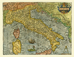
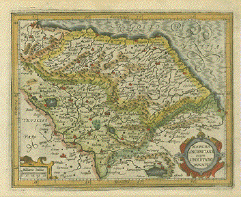
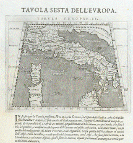
"Tavola Sesta dell'Europa - Tabula Europae VI" Italien

Type of print: Copper etching

Artist: Girolamo Porro

Published in: "Geografia cioe Descrittione Universale della Terra"

Publisher: Gio. Battista & Giorgio Galignani Fratelli

First published in: "Geographia" von Claudius Ptolemy

Edition: Italian edition

Editor: Giovanni Antonio Magini (1555-1617)

Text: Italian.

Published in: Venice

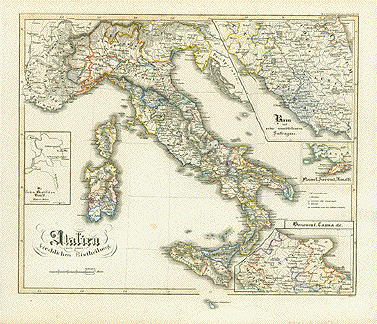
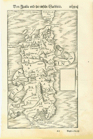
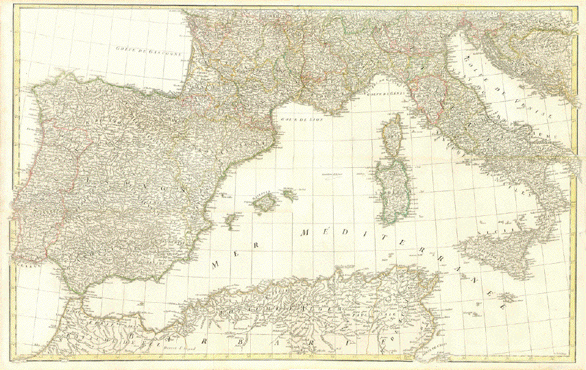
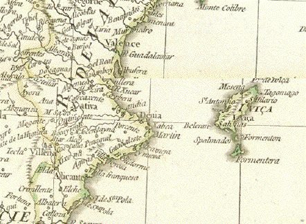
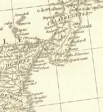
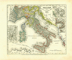
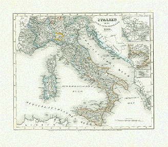
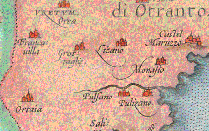
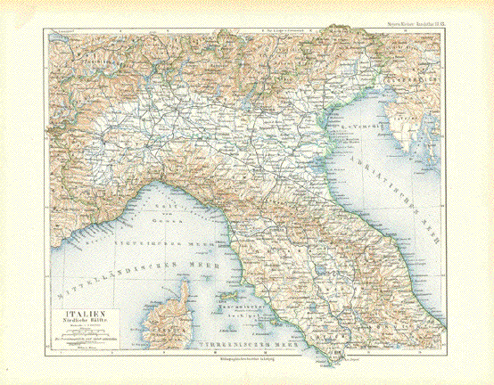
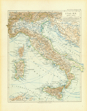
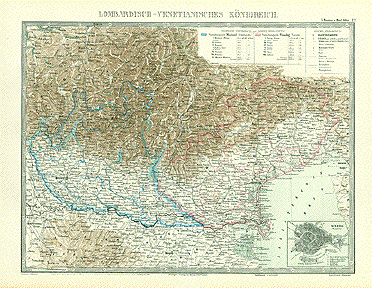
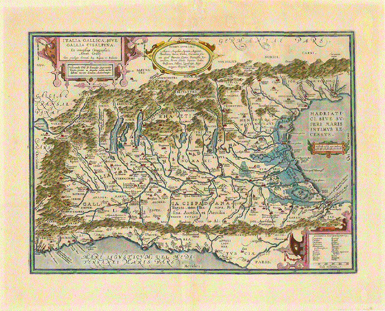
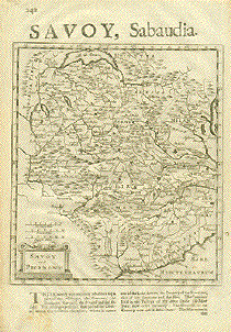
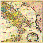
Date: 1598 Map shows all of Italy including parts of Sicily and Sardinia

Measurements:

Map size: Ca. 12,5 x 17 cm (ca. 4.9 x 6.7")

Page size: Ca. 28,5 x 19 cm (ca. 11.2 x 7.5")

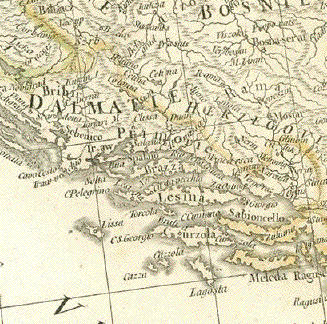
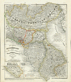
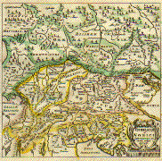
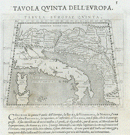
Reverse side: Balkan. See description below.

Condition: Lower margin is missing a piece of paper (see foto). Map itself flawless.

Reverse side

"Tavola Quinta Dell'Europa - Tabula Europae Quinta"

Map shows on reverse side: the entire Balkan and an undefined Italy to create the geographical oversight.

Order Nr. ITALIA236447 SOLD


"Le Royaume De Naples, Suivant les Nouvelles Observations de Messrs. de l'Academie Royale des Sciences, etc. Augmentées de Noveau". Copper engraving after Pieter van de Aa from "Nouvel Atlas, Tres Exact Et Fort Commode Pour Toutes Sortes De Personnes.......", published by Cóvens & Mortier in Amsterdam, 1730. Original outline coloring.

This map is almost identical to the above map. The decorative cartouche showing coats of arms, a volcano and interesting sea vessels adds a special touch to this map. Notice that on the right side is part of Albania and Corfu. In the upper left is southern Umbria withSpoleto, Norcia and Nocerna in the corner. In the lower left is northern Sicily, the Liparian Islands and the island of Ustica.

Map has vertical centerfold. A few light spots in margins. Two tiny spots on upper centerfold.

22.5 x 29.5 cm ( 8.8 x 11.6 ")

$ 240.00

Order Nr. ITALIAMAPPA1458

**********************************


"Die Staaten von Oberitalien naemlich das Lomb. Venet. Koenigreich Parma, Modena, Toscanna, Lucca, St. Marino u.d. Kirchenstaat 1850." Steel etching from "Neuster Zeitungs Atlas. Alter und Neuer Erdkunde" by J. Meyer, ca 1855. Original outline coloring.

At the very bottom of the map in the lower margin is Rome. The green outlined area west of Parma on the left side is titled "Sardinien". ??? In the lower left corner is an inset showin Rome and the church state to the south. The early roads are shown on the map.

Map has overall light age toning. God condition.

25.2 x 20.5 cm ( 9.9 x 8 ")

$ 70.00

Order Nr. ITALIAMAPPA235885


"Kronland Tyrol. u. Vorarlberg und souveraines Fuerstenthum Liechtenstein." Lithograph by H. Mueller for C. Flemming ca 1860. Some original hand outline coloring corresponging to the political regions listed in the lower right map key.

In the center of this very detailed topographical map is Meran. The map extends as far sout as Lago di Garda and as far north to Schongau and Weilheim in Oberbayern. In the upper right corner of the map is St. Gildgen and in the upper left corner is Ravenstein and Bodensee. In the lower left is a list of the highest mountains on the map.

Map has a few very light stains in margins and a small piece of lower left corner is mising. Light crease in upper left margins corner.

32 x 39.7 cm ( 12.5 x 15.6 ")

$ 75.00

Order Nr. AUSTRIA1031


"Lombardisch-Venetianisches Koenigreich". Lithograph by R. Seth after T. Bromme ca 1865. Original hand outline coloring corresponding to the political regions listed in the key.

Riva and Roveredo are located in the center of this detailed map. In the upper left are parts of Zurich Lake and Zug Lake. In the lower center of the map is Bologna. In the lower right corner is a detailed inset of Venice.

Map has a vertical centerfold.

26.5 x 37.7 cm ( 10.4 x 14.8 ")

$ 65.00

Order nr. ITALIAMAPPA1492


"Italia Gallica, sive Gallia Cisalpina" Copper etching from the atlas ãTheatrum Orbis Terrarum" by Abraham Ortelius. Antwerp, 1595. Hand coloring, probably in the 20th century. Reverse text: Latin.

This is a historic not a geographical map. It was added to the original atlas as the IV additamentum. The historical maps were all engraved by Abraham Ortelius himself and added to the atlas in five stages under the subtitle ãParergon, sive veteris geographiae aliquot tabulae". Since these maps were added only three years before Ortelius died, they were printed only in the last few editions of this magnificent atlas work.

Map shows area south of the Alps to a line from Pisa to Ravenna. Names of places and rivers in Latin. Great attention is paid to the rivers, the contributeries to the river Po, which also in ancient times, was a gigantic, most fertile and therefore wealthy area. Ortelius shows in particular the flood plains towards the Adratic Sea which was curse and blessing for the people and the agriculture.

Pleasant general age toning. Wide margins. Map has repairs in upper area visible on the reverse side. Centerfold has been reinforced.

34.5 x 46.5 cm (13.6 x 18.3")

$ 850.00

Order Nr. ITALIA MAPPA 1499


"Unter-Italien" Southern Italy.

Copper etching by G. Haubold after a drawing by Heinrich Kiepert (1818-1899). Published in Geographisches Institut Weimar, 1856. Original hand coloring

Detailed map of southern Italy including Sicily and a rather large size rendering of the island of Pantellaria. Inset maps of the Golf of Naples and its hinterland and of Malta / Gozo.

General age toning. Wide margins. Horizntal centerfold. Small repair in left margin on centerfold.

59 x 50.8 cm (23.2 x 20")

$ 380.00

Order Nr. ITALIA MAPPA1500


"Provincia di Abruzzo Ulteriore Secondo" Copper etching by Francesco Vallardi. Published in ãAtlante Geografico dell'Italia" Milano, ca. 1850. Faint original outline coloring.

The map exteds from Accumoli and Tino in the north to Nora, Alfedena and Casteldisangro in the south.

Clean map with margins.

33.7 x 52 cm (13.3 x 20.5")

$ 160.00

Order Nr. ITALIAMAPPA1524

**********************************


"Provincia di Abruzzo Ulteriore primo" Copper etching by Francesco Vallardi. Published in ãAtlante Geografico dell'Italia"

Milano, ca. 1850. Original outline coloring.

Clean.

33.2 x 52.4 cm (13.1 x 20.6")

$ 160.00

Order Nr. ITALIAMAPPA1525

**********************************


"Marcha Anconitana cum Spoletano Ducatu." Copper etching by Gerard Mercator. Published posthumously by Jan Jansson in "Atlas Minor". 1628. Original hand coloring. Text on backside in German about Spoleto.

Spoleto and Camarino are located near the center of this map with Ancona on the peninsula in the Adriatic Sea. Ravenna is in the upper left corner. To the left of the title cartouche is Lago di Celano (Fucino). On the left side near the center is Arezzo on the Chianna River.

Browning on margin edges and spotting in margins. Overall age toning.

14.4 x 18 cm ( 5.6 x 7 ")

Order Nr. ITALYMAPPA1444

**********************************


"Italie Partie Septentrionale" Northern Italy Steel etching by Th. Duvotenay. Published by Lemaitre.

Paris, ca. 1840

Shows Italy as far south as the line from Caserta, Benevento, Malfi, Minervino.

Narrow margins all around. Two vertical folds to fit book size. Very minor traces of age and use.

18.2 x 22.9 cm (7.2 x 9")

$ 70.00

Order Nr. ITALIAMAPPA234887

**********************************


"Royaumes De Naples Sicilie Et Sardaigne." Copper engraving by F. Delamarche, dated 1825. Original hand outline coloring.

The map reaches as far north as Orvieto and Spoleto. At the bottom center is the Island of Gozo.

Map has vertical centerfold. Light crease along centerfold.

27.4 x 37.5 cm ( 10.7 x 14.7 ")

$ 190.00

Order Nr. ITALIAMAPPA1489

**********************************


"Domino Fiorentino". Copper etching by Johann Janssonius in original coloring. Published in Amsterdam, ca. 1650.

Much of Tuscany is shown on this map with Florence as the centerpoint marked in red. The coast reaches from Liguria
in the north to Piombino in the south. In the upper right corner is a bit of the Adriatic Sea and Rimini. The lake above
the title cartouche is named "Lago di Perugia" (now Lake Trasimeno). Verso: Text in Latin.

Map has general toning and some small repaired tears in right margin. In the lower margin is a 10cm wide reinforcement
on the centerfolds far as the plate mark. The rest of the centerfold has normal reindorcement on the back. There is minimal spotting on the print. The overall condition is Better than Good.

38.2 x 49 cm ( 15 x 19.3 ")

$ 820.00

Order Nr. ITALIAMAPPA1317

**********************************


"Corsica and Sardinia"Steel engraving by J. & C. Walker ca 1850.

Left margin has been reinforced.

30.7 x 18.2 cm ( 12 x 7.1 ")

$ 70.00

Order Nr. ITALIAMAPPA1475

**********************************


"Das Alte Italien" Wood engraving ca 1875.

Interesting historical map with the old names of towns and regions.

Left margin is narrow. Backside is printed.

26 x 18.5 cm ( 10.2 x 7.2 ")

$ 45.00

Order Nr. ITALIAMAPPA1476

**********************************


"Trieste"

Plan shows the streets and surroundings of Trieste.
In the north is Prosecco and Contovollo.
In the south is Muggia and Monte Oro.

Wood engraving by Erhard ca 1870.
Backside is printed with a plan of Pola
and surrounding area.

13.3 x 11.4 cm (5.2 x 4.4 ")

$ 25.00

Order Nr. ITALIAMAPPA1456

**********************************


"Savoy, Saubaudia". Copper etching by Hermann Moll, ca 1725. Published in London.

Map shows the region betwee Lake Geneva at the top of the map and the Mediterranean at the bottom On the upper right is Lago Maggiore and Lago d'Orta. On the left center is Grenoble. Backside has some text in English about Switzerland.

Map is not printed straight on the page. Light browning on margin edges and some spotting on lower margin. Lower left margin corner has creases. Condition is Almost Good.

Map image: 21 x 18.5 cm ( 8.2 x 7.2 ")
Page size: 32 x 21 cm ( 12.5 x 8.2 ")

$ 170.00

Order Nr. FRANCEMAP1172

**********************************


"Italien. Noerdlicher Teil"

Map of northern Italy printed in color 1896. The names on the map are mostly the historical Latin names.
The main roads of the time are shown. Vertical centerfold. Good condition.

22.5 x 28.5 cm ( 8.8 x 11.2 ")

$ 35.00

Order Nr. ITALIAMAPPA248156


"Italien. Suedlicher Teil"

Map of southern Italy printed in color 1896. The names on the map are mostly the historical Latin names.
The lower left inset shows Sicily and the lower right inset shows the historical development of Syracusae.
The inset in the upper right show historical Campania.
The main roads of the time are shown. Vertical centerfold. Good condition.

22.5 x 28.5 cm ( 8.8 x 11.2 ")

$ 40.00

Order Nr. ITALIAMAPPA248153


"Das AdriaMeer mit seinen Uferstaaten .........1852". Steel etching from "Neuster Zeitungs Atlas. Alter und Neuer Erdkunde" by J. Meyer, ca 1855. Original outline coloring.

Map shows the Adriatic Sea and surrounding countries as they were in 1852. In the lower right is Avalon and Drumades. In the upper right corner is a bit of Hangary with the Theiss River. In the upper left is Bergamo and Lodi.

Map has a few minor spots in margins. Light browning on margin edges. General condition is Better than Good.

18.5 x 24.5 cm ( 7.2 x 9.6 ")

$ 70.00

Order Nr. ITALIAMAPPA1434

**********************************


Southern Italy

" Picentes, Vestini etc. Campania, Apulia, Lucania. Brutii.etc." Copper etching by Peter Bertius (1565-1629) for Philipp Cluver (1580 - 1623) , an early author of historic maps. His works were published long beyond his lifespan. The This map comes from a pocket size atlas (duodez): Philippi Cluverii. Introductionis in Universam Geographiam tam veterem quam novam Libri. Amsterdam, 1661. Originally colored.Centerfold. Size: ca.12 x 12,5 cm (ca.4.72 x 4.92"). Narrow margins all around, especially on right side. General toning. Minimal foxing.

This map shows the regions given in the title. The names of towns and peoples are from pre-Roman times. On the westside, the map begins south of Rome. In the southwest are the Liparian Islands and part of Sicily. East of Italy and the Adriatic Sea is ancient Illyria.

$ 120.00

Order Nr. ITALIAMAPPA1297

**********************************


Alto Adige - South Tyrol

" Vindeliciae et Norici conterminarunque terrarum antiqua descriptio". Copper etching by Peter Bertius (1565-1629) for Cluver Philipp (1580 - 1623) , an early author of historic maps. His works were published long beyond his lifespan. The This map comes from a pocket size atlas (duodez): Philippi Cluverii. Introductionis in Universam Geographiam tam veterem quam novam Libri. Amsterdam, 1661. Originally colored.Centerfold. Size: ca.12 x 12,5 cm (ca.4.72 x 4.92"). Narrow margins all around, especially on right side. General toning. Minimal foxing.

The central part of this map in yellow shows the region of southern Germany known in Celtic times as Vindelicia. In the middle is Lake Ammer with Pilsen Lake attached. The rivers, Lech, Guntia, Amper and Isar (to name a few) flow through this area that reaches from the Alps in the south to the Danube in the north. To the east is the ancient region of Noricum ( in pink) which begins with the Inn River in the west almost to Vienna and the region of the Murr River. The green area to the north of the Danube has a curve of the Rhine River in the far west and includes Bohemia in the northeast. South of the Alps is the region of Rhaetiae and Gallia Helvetii which is today Switzerland. The lakes of northern Italy and the northern part of the Adriatic Sea are in the yellow region.

$ 180.00

Order Nr. ITALIAMAPPA1184

**********************************


< Return to Page 2 Maps of Italy

< Return to Page 1 Maps of Italy

Maps of Sicily

Prints of Italy A-E

Prints of Italy - F-H

Prints of Italy I -N

Prints of Italy O-R

Prints of Italy S-Z

Prints of Milan

Prints of Naples

Prints of Rome

Prints of Sicily

Prints of Venice

Aquatint Etchings by J. Maina - Etchings of Ferarra, Florence, Piacenza, Rome, Verona and Venice.

Architectural Prints by D'Aviler - Copper etchings of Roman monuments.

Classical Rome - Copper etchings by Iacobo Lauro Romano

Classical Statues

Antique Statue Prints published by Rossi, 1704

Antique Prints of Rome

Fontane di Roma -Fountains of Rome

Herculaneum

Piranesi: Classical views of Rome.

Pompeii

Rossi- Classical Statues in Italian Homes and Gardens

Zocchi: Views of Florence

Prints of Milan

Prints of Alto Adige - South Tyrol

Vedute di Venezia - Prints of Venice

Maps of Italy

Maps of Sicily

Antique Prints of Sicily

Ordering and Payment

e-mail

Terms of Sale - Lieferbedingungen

Return to Home Page

Impressum

Datenschutz

© Rainer Rauhut