Maps of Italy

Enjoy viewing these historical maps of Italy. If you are interested in viewing maps of the various regions of Italy take a look at this page: Antique Maps of Regional Italy. For maps of Sicily, view: Antique Maps of Sicily. We have a page with maps of the Mediterranean which include Sardinia and parts of Italy: Antique Maps of the Mediterranean.

Ordering and payment

Lieferbedingungen

Sale! Discount!

30% Discount on All maps with an ITALIAMAPPA number on this page!

Take 30% off the listed price. !

We accept reasonable offers!

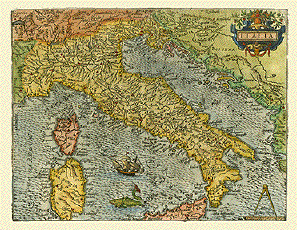
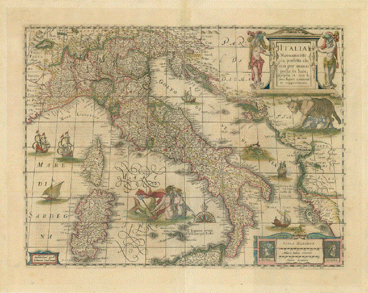
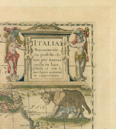
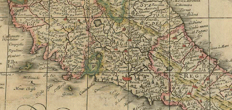
"Italia Nuovamente più perfetta che mai per inazi posta in luce, scolpita et con le suoi figure vivamente rappresentate"

Type of print: Copper etching

Author: Hendrik Hondius (1597-1651)

Publisher: Johannes Janssonius (1588-1664)

Color: Original hand coloring

Published: Amsterdam, 1644

Verso: Text in German

Very decorative map of Italy, including Sardinia and the northern tip of Sicily.

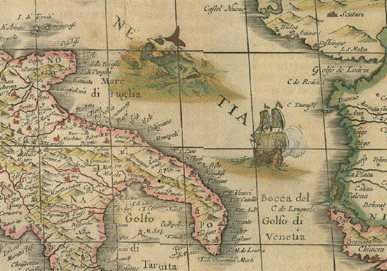
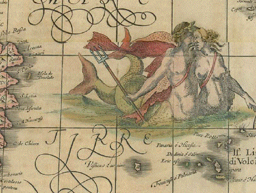
God Neptune and a mermaid, sail ships, sea monsters, the wolfe of Rome with Romulus and Remus drinking from her teats, Reneissance title cartouche, author's cartoche and mileage cartouche with the heads of Remus and Romulus

Condition: Map has been restored. Ruptures and holes have been repaired and the map has been laid down on Japan paper. The repairs do not show from the front side! In the margins are light lines from previous matting.

Map: 36,8 x 48,8 cm (ca. 14.5 x 19.2")

Full page: 44,8 x 57,4 cm (ca. 17.6 x 22.6")

$ 1250.00

Order Nr. ITALIAMAPPA238857


"Italie Antique Mappa Nova a F. Delamarche 1829"

Copper engraving published in "Atlas de la Geographie Ancienne, du moyen age, et moderne, (Paris) 1832"

Published in Paris by Maison Delamarche.

Map shows ancient Italy with many of the antique names for topography and settlements.

Vertical centerfold as published. Original outline coloring.
Minor signs of age and use in margins. Small repairs in upper and lower margins on fold line.

30.5 x 35 cm ( 12 x 13.7 ")

$ 80.00

Order Nr. ITALIAMAPPA242157


"L'Italie". Copper etchingby Rigobert Bonne (1729-1795) for "Atlas de toutes les parties connues du globe terrestre" by Guillaume Thomas Francois Raynal (1713-1796). Published 1780 in Geneva. Modern hand coloring.

Italy is shown on this map with much detail. Notice that even the very small surrounding islands are shown as well as many rivers. In the northwest is Lake Geneva and in the northeast the map reaches as far as Hungary.

Map has overall age toning and some light creasing in right margin. General condition is otherwise Very Good.

31.5 x 21.8 cm ( 12.4 x 12.4 ")

$ 170.00

Order Nr. ITALIAMAPPA1343


"Carte de L'Italie Ancienne" . Steel etching by Pierre Tardieu for the "Atlas Universal", dated 1858. Original hand coloring.

The map shows ancient Italy, with the names of prehistoric peoples. The town and city names are of special historical interest.

Map has horizontal centerfold. Wide margins. On each end of the centerfold is a small, repaired tear on margin edge. A few very minimal spots in margins. General condition is otherwise Almost Very Good.

54.5 x 39.7 cm ( 21.5 x 15.6")

$ 180.00

Order Nr. ITALIAMAPPA1422


"Italia". Copper etching by Johann Bussemacher, ca. 1590. Modern hand coloring.

At first glance this map is very decorative with a sailing ship and a large imaginative fish in the wavy Tyrrhenian Sea, a pleasant title
cartouche and a compass in the lower right corner. Studying the map more closely, one appreciates the great detail in locations of cities
and rivers that were known in the 16th Century. Bussemacher's name is at the bottom of the map.Verso: Text in Latin.

Map has wide margins with minimal light print showing from backside. One light crease in lower margin and a small repaired tear in
lower margin on centerfold. Overall condition is Almost Very Good.

20.6 x 26.8 cm (8.1 x 10.6 ")

Order Nr. ITALIAMAPPA1312 SOLD


"Carte de L Italie Meridionale"
( Etats Pontificaux et Royaume de Naples )

Wood engraving ca 1875. Reverse side is printed. Horizontal centerfold. Minor signs of age.

32 x 21.5 cm ( 12.5 x 8.4 ")

$ 40.00

Order Nr. ITALIAMAPPA238984


"Italien" Steel etching by Thomas after the drawing by A. Theinert. Ca.1870.

Original outline hand coloring

Map shows all of Italy down south to Pantellaria, Limosa, Lampedusa Gozo and Malta. Corsica. Lower left inset

Map has some spotting.

33.8 x 27.4 cm (13.3 x 10.8")

$ 60.00

Order Nr. ITALIAMAPPA234773


"Italien mit der dalmat.-albanesischen Kueste 1855 revidiert 1858" Steel etchinhg by Rhode for Bibliographisches Institut Hildburghausen. Schweinfurt, 1858. Original hand coloring.

Insets: Left side. Mailand (Milano) and surrounding. Right side: Rome, Naples, Malta


Map has general age toning. Some very minor traces of age. Very clear and good impression Vertical centerfold.

19 x 23 cm (7.5 x 9")

$ 50.00

Order Nr. ITALIA MAPPA 234772


"Italien mit der dalmat.-albanesischen Kueste 1849" Steel etchinhg by Rhode for Bibliographisches Institut Hildburghausen. Schweinfurt, 1849. Original outline hand coloring.

Insets: Rome, Naples, Malta on the right side.

Clean

19 x 23 cm (7.5 x 9")

$ 50.00

Order Nr. ITALIAMAPPA234699


ãItalien unter den Langobarden nebst den Besitzungen der griechischen Kaiser". ( Italy under the Langobards including the possessions of the Greek cesars.) Steel etching by E. Luther. 1846.Slight original border coloring.

Insets: Lower Italy from the 9th up to the XIth century. The Dutchy of Trient. The State of Venice. Monte Casino. The surrounding of Rome. The surroundings of Capua.

Some minor spotting in margins. Some creasing along vertical centerfold. Repair in lower margin on fold.

Page size: 37 x 43.8 cm (14.6 x 17.2")

$ 120.00

Order Nr. ITALIAMAPPA1498


ãItalien unter den saechsischen und fränkischen Kaisern bis zu den Hohenstaufen". ( Italy under the Saxon and Franconian cesars up to the Hohenstaufen.) Steel etching 1846. Original borderline coloring.

Some minor spotting in margins. Small repaired tear on left margin edge.

Page size: 37 x 43.8 cm (14.6 x 17.2")

$ 120.00

Order Nr. ITALIAMAPPA1496


ãItalien von 1450 bis 1992".( Italy between 1450 and 1792.) Steel etching by Ad. Gottschalck. 1846. Original borderline coloring.

Historical map shows Italy including Gozo and Malta and Dalmatia. Side maps: Italy between 1793 to 1815. Plan of La Valetta Island of Malta, Plan of battlefield Pavia (1525). The principalities along the lower run of river Po: Mantua, Padua,, Modena, Ferrara. Plan of Genova with surroundings. Plan of Venice. The lagoons from Torcello to Chioggia.

Clean. Traces of age and use. A few insignificant repaired tears in margins. Faint vertical centerfold crease.

Page size: 37 x 43.8 cm (14.6 x 17.2")

$ 180.00

Order nr. ITALIAMAPPA1494SOLD


ãItalien nach seiner kirchlichen Eintheilung". ( Italy according to its church provinces.) Steel etching by Edler. 1846. Original hand coloring.

Insets: Rome and it immediate suffragans. The seven basilicas of Rome. Naples, Sorrento, Amalfi. Benevent, Capua, etc.

Some minor spotting.

Page size: 37 x 43.8 cm (14.6 x 17.2")

$ 150.00

Order Nr. ITALIAMAPPA1497SOLD


Antique Maps of Regional Italy

Antique Maps of Sicily

Antique Maps of the Mediterranean

Prints of Italy A-E

Prints of Italy - F-H

Prints of Italy I -N

Prints of Italy O-R

Prints of Italy S-Z

Prints of Milan

Prints of Naples

Prints of Rome

Prints of Sicily

Prints of Venice

Aquatint Etchings by J. Maina - Etchings of Ferarra, Florence, Piacenza, Rome, Verona and Venice.

Architectural Prints by D'Aviler - Copper etchings of Roman monuments.

Classical Rome - Copper etchings by Iacobo Lauro Romano

Classical Statues

Antique Statue Prints published by Rossi, 1704

Antique Prints of Rome

Fontane di Roma -Fountains of Rome

Herculaneum

Piranesi: Classical views of Rome.

Pompeii

Rossi- Classical Statues in Italian Homes and Gardens

Zocchi: Views of Florence

Prints of Milan

Prints of Alto Adige - South Tyrol

Vedute di Venezia - Prints of Venice

Maps of Italy

Maps of Sicily

Antique Prints of Sicily

Ordering and Payment

e-mail

Terms of Sale - Lieferbedingungen

Return to Home Page

Impressum

Datenschutz

© Rainer Rauhut